The Euro-Wabanaki Wars (17): Beginning of Queen Anne’s War

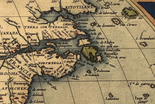
In 1701, the War of the Spanish Succession (1701-1714) broke out in Europe. It was triggered by the death of childless Charles II of Spain, leading the French Bourbons and the Austrian Habsburgs to begin fighting over the Spanish Empire.

The War of the Spanish Succession spilled over into North America, where it was known as Queen Anne’s War, and involved the colonial empires of Great Britain, France, and Spain.  It was battled with Indigenous allies on three fronts: 1) Spanish Florida and the English Province of Carolina, 2) English St. John’s and Newfoundland, and the French at present-day Placentia, and 3) French Acadia with English New England on the Maine frontier.   

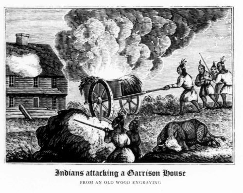
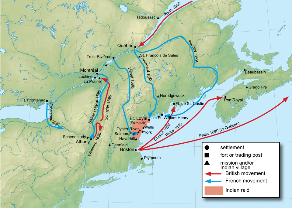
On August 6, 1703, the War began in Maine when the Royal Governor of New France, Philippe de Rigaud Vaudreuil, sent an expedition force of 500 French and Mi’kmaq from the St. Lawrence River Valley to make a massive assault on all the English coastal towns and forts stretching from Wells to Falmouth.

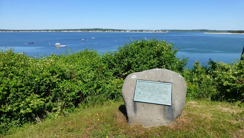
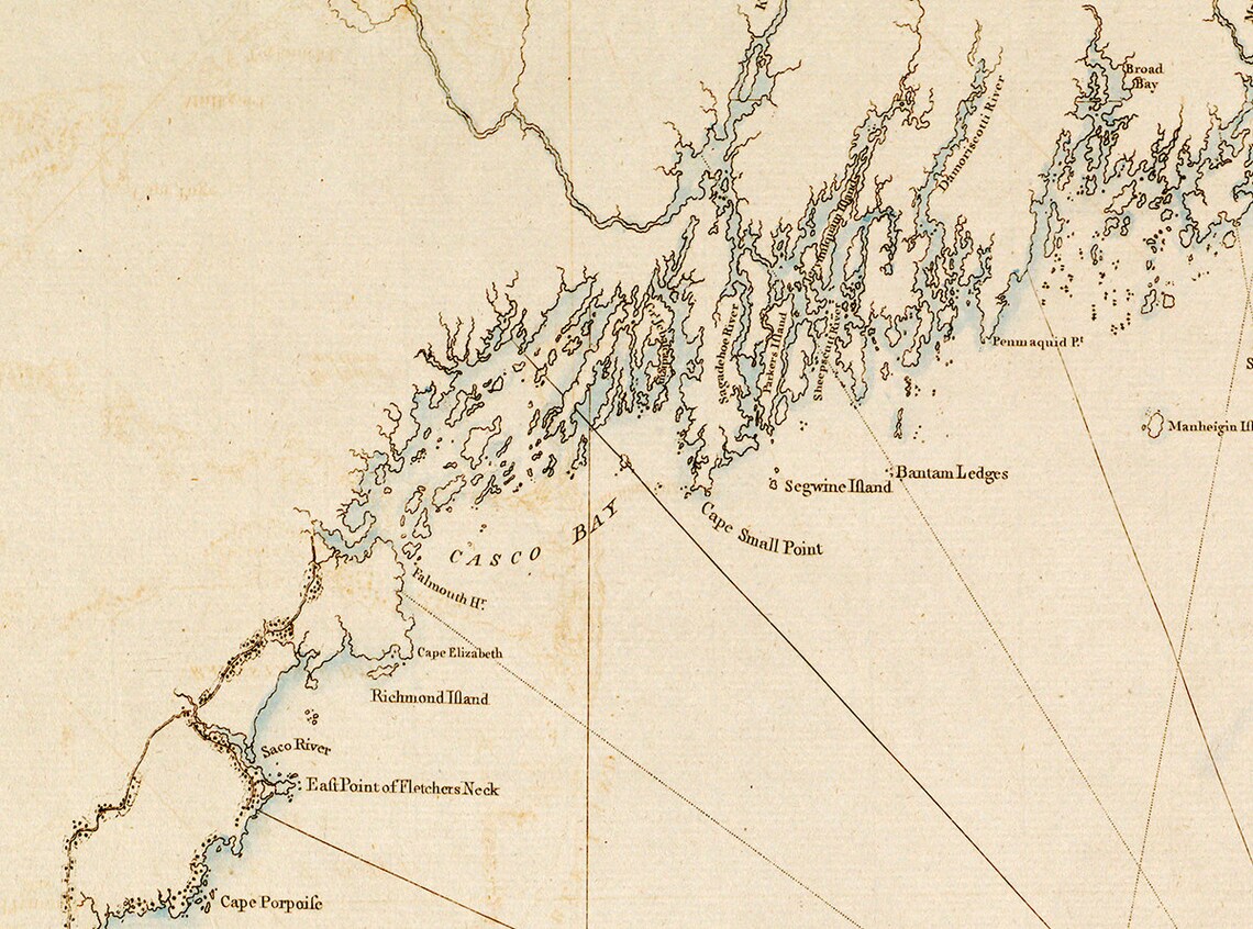
This expedition force laid coastal Maine to waste once again. As described by Willis (1833, pp. 7-8): “The inhabitants of Purpooduck [near Cape Elizabeth] were the most severe sufferers in this sudden onset. There were nine families then settled upon and near the point who were not protected by any garrison. The Indians came suddenly upon the defenseless hamlet when the men were absent, killed 25 persons, and took several prisoners. Among the killed were Thomas Lovitt and his family, Joel Madeford or Madiver, and the wives of Josiah and Benjamin Wallis and Michael Webber. The wife of Joseph Wallis was taken captive; Josiah Wallis made his escape to Black Point with his son John, then 7 years old, part of the way upon his back.

Spurwink, principally occupied by the Jordan family, was attacked at the same time, and twenty-two persons by the name of Jordan were killed and taken prisoners. Dominicus Jordan, the third son of the Rev. Robert, was among the killed, and his family, consisting of six children, was carried to Canada. His brother Jeremiah was among the prisoners, who was subsequently called French Jeremy, from the circumstance of his having been carried to France.

The whole country, from Purpooduck Point to Spurwink, was covered with woods, except the few spots which the inhabitants had cleared. This afforded facilities to the Indians for concealment and protection. From these coverts, they made their sudden and cruel visits, then returned to mingle again with the other wild tenants of the forest, beyond the reach of pursuit.”

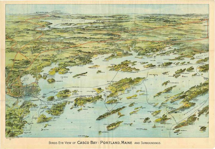
At this point, only the fort and settlement at Falmouth remained. “This was the most considerable fort on the eastern coast and was the central point of defense for all the settlements upon Casco Bay; under its protection, several persons had collected to revive the fortunes of the town” (Willis, 1833, p. 8). The veteran Major John March was in command of the fort.

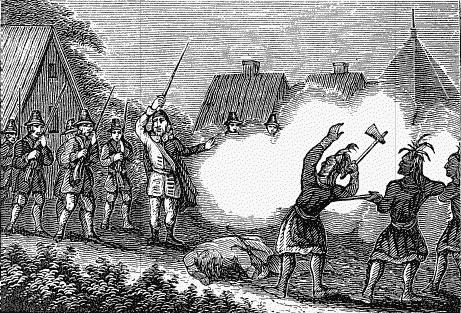
The assault began by deception and treachery (Drake, 1910, pp. 159-160):  “While the main body of assailants was kept out of sight, three chiefs boldly advanced to the gate with a flag of truce. At first, March paid no attention to the flag bearers but finally went out to meet it, taking with him two others, all three being unarmed. His men were, however, warned to be watchful against treachery. Only a few words had been exchanged when the Indians drew their hatchets from under their blankets and fell with fury upon March and his companions. Being a man of great physical strength, March wrested a hatchet from one of his assailants, with which he kept them at bay until a file of men came to his rescue. Luckily, he escaped with a few slight wounds …

Having failed to gain the fort by treachery, the savages next fell upon the scattered cabins outside, which were soon blazing on all sides. After this was done, they returned to attack the fort. For six days, the weak garrison defended itself unflinchingly. During this time, the besiegers were joined by the confederate bands, Falmouth holds, who had been destroying all before them out at the west. Beaubassin, the French leader, now pressed the siege with greater vigor and skill. Covered by the bank on which the fort stood, the savages set to work undermining it on the waterside. For two days and nights, they steadily wormed their way under the bank toward the palisade without any hindrance from the garrison and were in a fair way to have carried the fort by assault when the arrival of the provincial galley compelled them to give over their purpose in a hurry, as that vessel’s guns raked their working party. On the following night, they decamped. Two hundred canoes were destroyed, and an  English shallop retaken by the relieving galley.”

One hundred and thirty persons were either killed or taken captive during this bloody conquest. Fear and dismay now filled the hearts of the settlers, for Maine had come very close to receiving a death blow. Only the strongest-willed remained, hunkered down in their garrisons, performing only the most necessary outside labor under armed guard.

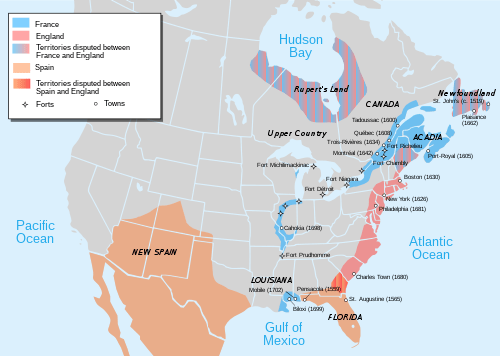
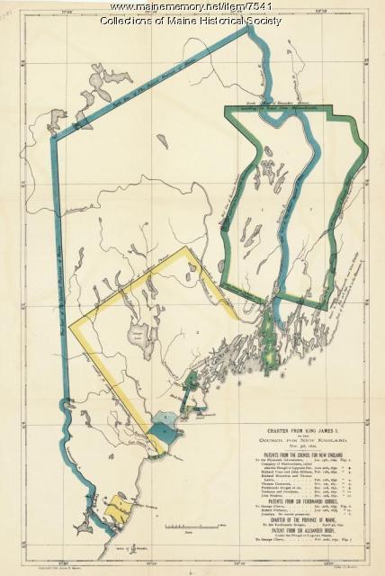
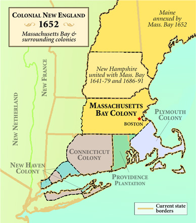
Illustration: European occupation of North America at the start of Queen Anne’s War. Wikimedia

Bibliography

Drake, S. A. (1887). The Border Wars of New England, commonly called King Williams and Queen Anne’s Wars. Charles Scribner’s Sons: New York.

Willis, W. (1865) The history of Portland from 1632 to 1864. Bailey and Noyes: Portland.

The Euro-Wabanaki War (16): Maine after King William’s War  

When King William’s War ended in 1698, many of the settlers who had fled the bloodshed returned to their shattered settlements and homes. These early colonists were built of incredibly resilient stock.

As Williamston (1889, pp. 29 – 31) describes: “Destitute of homes, yet attached to the places of their birth, hundreds of freeholders, or the heirs of deserted realties, returned, during the season, and visited former abodes, or half wilderness lands; many repaired their dilapidated cottages, and more perhaps constructed habitations. Men with their families removed to the peninsula of Casco, Purpooduck, and Spurwink, in Falmouth; to Black Point and Blue Point in Scarborough, to Winter Harbor and the Falls in Saco; to Cape Porpoise; and to Cape Neddick; and during the present and succeeding summer, those places were repeopled with several abiding families.”

The returning settlers felt compelled to take up a quasi-military life: “Garrisons, usually under a militia command, provided nuclei for small settlements either just outside or within a stockade. During daylight, men and women worked in their fields under the protection of scouts and guards. For most of the period, English Maine lived in a state of virtual siege. Only the larger seaports – Boston, Salem, Portsmouth, Kittery – enjoyed sufficient security to benefit from the military expenditures from Great Britain (Anonymous, 2010).”

Postwar Wabanaki migrations

As the 18th century drew to a close, the Wabanaki were hungry, exhausted, and largely displaced from their traditional fishing and hunting grounds. Prins and McBride (2008, p. 189) suggest: “The surviving Wabanakis were desperate to return to their village gardens, and to hunt, fish, trap and trade as before. But the fur market had crashed. With the flow of furs from the Great Lakes no longer checked by Iroquois warfare, supplies rose just as the European demand dropped. For Wabanakis these market changes added to their problems.

Under the watchful care of Jesuit missionaries, many Wabanaki relocated to the Missions of Bécancour, and St. Francis. “Although they created new lives for themselves in French Canada, many exiles never gave up the hope of retaining their lands in Maine from the English. While life in the mission villages provided residents with a safe haven and ready access to food, firearms, and other trade goods, physical and material security came at a cost. Although the native people of the mission villages could come and go as they pleased and maintain their own political structure, they remained fundamentally dependent on French aid and hospitality. Seeing the native people as ready allies in their war with the English, the French routinely used the flow of trade goods to exert Influence over the native peoples’ collective and individual choices of war and peace. … As the frontier wars progressed over the first half of the eighteenth century, native war parties striking the communities of coastal Maine increasingly originated from French Canada rather than the resident native populations.” (Dekker, 2015, p. 4)

Sébastien Rale builds a mission at Norridgewock (Nanrantsouak)

In 1694, Jesuit Sébastien Rale arrived at Norridgewock on the Kennebec River and built a mission at the site where Father Druillettes had toiled almost a half-century earlier. The faith had been kept alive at Norridgewock by occasional visits of missionaries, but no permanent pastors had been in residence until Father Rale arrived.  

Father Rale soon became an expert on the Wabanaki dialect and gave his catechetical instructions in their native tongue. He wrote a detailed Wabanaki dictionary, which was later stolen in an English raid. Rale would become a powerful opponent of the English, but in his early years at Norridgewock, he toiled quietly among the Wabanaki.

Not much is known about his early activities, but Rale’s arrival during King William’s War certainly placed him in a precarious position. As described by Schuyler (1915, pp. 167-168): “The English colonists greatly outnumbered the French, but the Indians were mostly allied with the latter. At the very beginning of his career at Norridgewock, Father Rale must have realized how difficult and how dangerous his position was. His was the most western of the Acadian Missions. The New England colonists were uncomfortably near him, and many were the anxieties and sorrows caused by this proximity. He became almost at once the object of English suspicion and accusation and later of armed attack. Every foray of New England colonists was attributed to him as the prime cause.

Rale became known as the “Apostle of the Abnakis” and was one of the most prominent names in the history of missionary activity on Maine’s frontier. He would be a central player in the French and Indian Wars for thirty years.

Illustration:  Indians Attacking a Garrison House, from an Old Wood Engraving. Collection of the Dover Public Library, New Hampshire

Bibliography:

Anonymous (2010). 1668-1774, Settlement and Strife. Maine History Network. The Maine Historical Society, Portland.  https://www.mainememory.net/sitebuilder/site/897/page/1308/print

Dekker, M. (2015) French & Indian Wars in Maine. The History Press. Charleston, South Carolina.

Prins, H. E. L., & McBride, B. (2007). Asticou’s Island Domain: Wabanaki Peoples at Mount Desert Island 1500-2000. Acadia National Park. Ethnography Program. National Park Service.

Schuler, H. C. (1915) The Apostle of the Abnakis: Father Sebastian Rale, S. J. (1657-1724). Catholic Historical Review 1(2): 164-174.

Williamston, W. D. (1889) The history of the state of Maine: From its first discovery in A.D. 1602 to the separation, A.D. 1820, exclusive. Glazers, Masters, and Smith.

Euro-Wabanaki Wars (14): The Stagger Towards Peace in King William’s War

In the spring of 1693, James Converse was made Commander-in-Chief of the eastern forces, consisting of all the garrison soldiers and 350 new recruits. He began a campaign along the coast, hunting down and harassing groups of Wabanaki at  Piscataqua, Wells, Sheepscot, Pemaquid, Teconnet, and Saco. This rampage brought many of the starving and exhausted Wabanaki to desire peace. 

On August 11, thirteen Sagamores representing tribes from Saco, Androscoggin, Kennebec, and Penobscot, including Sagamores Madockawando and Moxus, came to the garrison at Pemaquid and asked to treat. 

The English commissioners, John Wing, Nicholas Manning, and Benjamin Jackson demanded that “the Wabanaki pledge total subservience to the British Crown, confess to having caused the war, and admit that the French had instigated it. The treaty stipulated that the eastern tribes cease hostilities with the English, release all English captives without ransom, settle disputes in English courts rather than through armed conflict, and recognize English land claims”. (Dekker, 2015, pp. 41 – 42)

Despite the harsh stipulations, the thirteen sagamores felt compelled to sign the agreement. However, its signing provoked outrage among the Wabanaki sagamores, who were not present. They flatly rejected the treaty due to its blatant English bias.

“Acceptance of the treaty was further undermined when it was learned that Madockawando, despite questionable authority to do so, had sold a large parcel of land to Sir William Phips in the area now encompassing Thomaston, Warren, and Cushing” (Dekker, 2015, p. 42).

Dismayed by the breach within the Wabanaki Confederacy, the French also depicted the peacemakers as traitors. Under pressure, the thirteen signatories were forced to close ranks with the rest of the Wabanaki sagamores, and a reunified Wabanaki Confederation resumed its fight against the English.

On the 18th of July 1694, a force of 250 under Madockawando, Bomaseen, and Toxus, “again destroyed Dover in New Hampshire and, after plundering places further westward, returned to Piscataqua on August 20th, when a large party of them crossed over into Kittery with intent, manifestly, to complete the ruin of Maine. At Spruce Creek, they killed three, and at York, one, where they also took a lad prisoner. On the fifth day of their visit, they made a bold attack upon Kittery, and slew eight persons …” (Williamson, 1889, p. 640)

The bloody war would continue on for another two years. Periodic attempts by the Wabanaki for peace were consistently thwarted by English deceit.   “In November 1694, four Wabanaki were killed under a flag of truce at Saco, and three others were taken prisoner a few weeks later in similar circumstances. When the Wabanaki released some of their captives during the following spring, the English refused to reciprocate. Then, in February 1696, several Indians were killed after they were lured into Fort William Henry to negotiate a settlement” (Ghere, 1995, p.127).

Last battle of King William’s War

In the late spring of 1696, in what turned out to be the final battle of King William’s War, Fort William Henry fell to a mixed force of 80 French and Canadian soldiers and several hundred Wabanaki, led by Pierre Le Moyne d’Iberville.  Under siege by d’Iberville’s warships, the fort, which was considered so formidable, was found to be quite the opposite. The stone walls were built with poor-quality mortar and soon began to crumble under the concussive force of their own guns. Making matters even worse, the fort had no water source within its walls.  Greatly outnumbered,  the commander of the fort, Captain Pasco Chubb, was forced to surrender. He and his men were escorted to Boston and exchanged for French and Indians imprisoned there.

In 1697, Boston received news that England and France had signed the Treaty of Ryswick in the Netherlands, bringing an end to the Nine-Years’ War. However, it was not until the summer of 1698 that the French allies in the Wabanaki Confederation learned of the European peace and initiated their own negotiations with their enemies in New England. In January 1699, representatives of the Confederation (Penobscot, Kennebec, Androscoggin, and Saco) traveled to Mere Point in present-day Brunswick to make peace. On January 8, they signed a treaty that closely mirrored the one they had signed at Casco in 1693, which they had been furiously rejecting for the last six years. Now, so exhausted and desperate for peace and the resumption of trade, they were resigned once again to signing the humiliating document.

The only protest that they made was: They refused to accept the English king as “our common father,” pointing out that the King of France held that honor.  However, now that the French and English Kings had made peace as “brothers,” the Wabanaki would be willing to call the English monarch “Uncle King William.” As such, they said they were thankful that their “uncle” had accepted them “into the league of friendship” (Prins, 2002, p. 364).

As the 18th century drew to a close, the boundaries between French and English claims in North America remained unresolved, and the coast east of Wells was nearly devoid of English settlers. The Wabanaki’s suffering would continue unabated, now with little aid from the French and an English trade embargo.  An uneasy peace settled over Maine, but it would be very ephemeral, as the fighting would be renewed just four years later.

Illustration: Map of King William’s War. Wikimedia Commons.

Bibliography:

Dekker, M. (2015) French & Indian Wars in Maine. The History Press. Charleston, South Carolina.

Ghere, D. L. (2015) Diplomacy & War on the Maine frontier, 1678-1759. In: Judd, R.W., Churchill, E. A., and Eastman, J. W. (eds.). Maine: The Pinetree State from Prehistory to the present. University of Maine Press, Bangor. pp. 51–75.

Prins, H. E. L. (2002) The crooked path of Dummer’s treaty: Anglo-Wabanaki diplomacy & the quest for aboriginal rights. H. C. Wolfart (ed.). Papers of the Thirty-Third Algonquian Conference, University of Manitoba: Winnipeg. pp. 360 – 377.

Williamston, W. D. (1889) The history of the state of Maine: From its first discovery in A.D. 1602 to the separation, A.D. 1820, exclusive. Glazers, Masters, and Smith.

Euro-Wabanaki Wars (13): Murderous raids of Madockawando in 1692.

In King Philip’s War, raids on English settlements were rare during the winter months, when the Wabanaki disappeared into the forest on their yearly hunts. This all changed dramatically in the winter of 1692, when Madockawando and Father Thury led 200-300 Wabanaki on snowshoes in a bloody raid on York during King William’s War.

 As Drake (1910, p. 73) tells the story, “On the morning of February 5, 1692, the village of York lay locked in the arms of winter. Since daybreak, it had been snowing heavily, so few of the inhabitants were stirring. At this hour, nothing could be heard but the muffled roar of the waves beating against the ice-bound coast or the moaning of the wind as it swept through the naked forest. All else wore its usual quiet.

Suddenly, a gunshot broke the stillness. At that sound, the village awoke. The startled settlers ran to their doors and windows. Out in the darkness and gloom, they saw a body of armed men fronting them on every side. Some tried to escape by their front doors. A storm of bullets drove them back. They next made for the back doors. Death met them at the threshold. They saw themselves surrounded, entrapped. On every side, the rattle of musketry, mingled with the loud yells of the assailants, drowned the voices of nature—moaning sea and rising storm. The village was surrounded, and retreat cut off, and a carnival of murder was to join its horrid uproar to that of the elements.

… The savages quickly burst open the doors with their axes, killing and scalping all whom they met. As soon as one house was carried and its inmates butchered, it was first ransacked and then set on fire; the assailants then rushed off in pursuit of new victims. In a short time, the village was blazing in twenty places.”

 Accounts differed on the number slain, but the death toll was substantial, with 50 to 100 being slaughtered. Dozens of others were taken captive, and all but four garrison homes were burned to the ground.

To the east of York, the small, struggling village of Wells was initially spared. However, in June, it was assaulted by a formidable body of warriors led by Madockawando and Moxus, supported this time by a small group of Acadian French led by Portneuf and St. Castin. The battle started with the assailants swooping out of the surrounding forest, “screeching, brandishing their weapons aloft, and hurling shouts of defiance at the garrison as if they expected to frighten it into surrender by a show of numbers and noise” (Drake, 1910, p. 78).

The stockade was defended by twenty-nine soldiers commanded by Captain James Converse. Fourteen had just arrived a few days earlier in two sloops. In a bitter firefight, the soldiers held fast in their garrison, their guns reloaded by several stout-hearted women. Failing to breach the walls, the assailants then tried to capture the sloops, with several losing their lives in the attempt, including a Frenchman. ” When night put an end to the fighting, Storer’s men had everywhere more than held their own.” (Drake, 1910, p. 79).

Throughout the night, the warriors shot flaming arrows into the fort to keep the besieged on alert and to wear them out. The combatants lay so close together that the firing was interspersed with boastful bantering on both sides.

In the morning, the assailants made another frontal assault on the stockade, but a rapid discharge of musketry again repulsed them.

Exasperated by repeated failures, the savages next made another dangerous attempt upon the sloops, now lying lashed together for mutual protection out in the stream. A fire raft was hurriedly put together, the combustibles lit, and the raft shoved off from the shore and left to drift down upon the vessels with the tide. The same fatality attended this effort as the others. A puff of wind drove the blazing mass against the bank, where it burned harmlessly out.

Force having failed, the discouraged besiegers resorted to stratagem. A flag was sent to demand a surrender. Ensign Hill went out to meet it. When the message was brought to Converse, he returned for an answer “that he wanted nothing but men to come and fight him.” The wrathful envoys retorted the threat to cut the English “as small as tobacco” before morning. Converse then broke off the conference with a brusque invitation to make haste, for he wanted work. “The savage, who held the flag, then dashed it to the ground in a rage and ran off one way, while Ensign Hill ran off in another, each one eager to get under cover as quickly as possible. It was well for Hill that he took the alarm when he did for a number of shots were fired at him from an ambush, treacherously contrived by the savages, in case their demand was refused. Thanks to fleetness of foot, Hill got into the garrison unhurt.

After putting their one captive, John Diamond, to death with excruciating torture, the discomfited crew of white and red savages slunk silently away between dark and daylight, leaving some of their unburied dead behind them.” (Drake 1910, pp. 80 – 81).

Illustration: Memorial plaque in York, Maine.

Bibliography:

Drake, S. A. (1887). The Border Wars of New England, commonly called King Williams and Queen Anne’s Wars. Charles Scribner’s Sons: New York.

Euro-Wabanaki Wars (12): Expedition of Benjamin Church in 1690

In 1690, Benjamin Church was sent to Maine by the Massachusetts authorities to wage a major offensive against the Wabanaki. He was ordered to root out and destroy their permanent villages upstream that had been harassing the coastal English settlements. 

As Drake (1887, pp. 66-67) describes, “At safe distances up these rivers, varying from sixty to a hundred miles, the tribes who usually acted together against the English had permanent villages, whence war parties could easily slip down unperceived to the coast, join their forces at some point mutually agreed upon, and fall upon such settlements as had been marked for destruction. Small and insufficient garrisons posted at the mouths of these rivers had utterly failed to put a stop to these inroads. Scouting the border could not do it. To destroy the enemy’s villages was the only alternative. Root out the nests, and the vultures would fly away.”

Church, leading 300 men, arrived in Casco Bay on September 11th. Landing at Maquoit Bay, he marched directly to Fort Andros, which he found abandoned. Then he continued for another forty miles to the principal Penobscot village at Great Falls (in today’s Lewiston). As he approached, they were spotted, and most of the warriors fled, leaving the women and children to their fate. Three or four men were shot in the river while trying to escape. Once inside the village,  Church discovered five gaunt and starving English captives, and in retaliation, butchered seven random villagers. 

From the captives, Church learned that the warriors had gone to Saco, and he resolved to chase after them. After burning the village to the ground and destroying the Indian’s store of corn, Church and his men clambered aboard his ships, taking as hostages nine family members of the sachems Kancamagus and Worumbo (Dow, 2025). The rest of the women and children of the village were then brutally slaughtered, except for a few old women, left to tell the tale.

As Williamston (1889, p. 66) related, “The wives of the two Sagamores and their children were saved and sent on board his vessels in consideration of a solemn promise made by the women that eighty English prisoners should be restored. But it is painful to relate, and nowise creditable to the usual humanity of Major Church, that the rest of the females, except two or three old squaws, also the unoffending children, were put to the tomahawk or sword.—The old women, he left with some necessaries and this errand – tell the Sagamores, they may find their wives and children at Wells.”

Just before sailing, the group was joined by Anthony Brackett, who had escaped his captivity at Falmouth. He would serve as a valuable guide.

Church then sailed to the mouth of the Saco River, where he surprised some Wabanaki who were fishing. He killed two of them in a brief skirmish and freed from them a captive, Thomas Baker, who told him that the Indians had hidden beaver pelts at Pejepscot (Brunswick). Backtracking, Church found the pelts but no more Wabanaki to harass.  At this point, some of his weary men demanded that it was time to return home, and when his full council agreed,  Church accepted, and the group loaded up and headed across Casco Bay to Cape Elizabeth.

After spending the night, his group was viciously attacked by some of the warriors he had been pursuing but had not yet found. Seven of his soldiers were killed and twenty-four wounded before the Wabanaki evaporated into the woods again. Church searched high and low for them to re-engage, but to no avail. He finally gave up and returned to Portsmouth on September 26 to an icy cold reception from the local authorities.

Meanwhile, as he had hoped, his capture of the Indian women at Androscoggin yielded for him a positive result. In October, several chief sagamores came to Wells, hoping to retrieve their women and children. Under a flag of truce, they told  Captain Elisha Andros “with real or pretended sincerity- it is hard to say which – they declared that the French had made fools of them, that they would not fight against the English anymore, and that they were ready to make a treaty whenever the English were”  (Drake, 1887, p. 69).

It seems likely that the Wabanaki’s statement was disingenuous. By now, they must have known of Phips’ defeat at Ontario and likely had no intention of giving up anything more than the minimum to regain their women and children. They had brought with them only ten captives, and after a drawn-out negotiation that took six days, they promised to deliver more captives the following May and remain peaceful until then.

When the English commissioners returned in May for those captives, no one came to meet them, and the local Wabanaki claimed they knew nothing of the expected rendezvous. This, as told by Drake (1887, p. 70),  “was a sinister omen and forewarned another outbreak. Breathing time, however, had been gained, which was much to people who were worn down and dispirited by last year’s reverses. It proved, however, a mere lull inthe storm.”

IllustrationEngraved portrait by Paul Revere that was believed to be of Benjamin Church.  Yale University Art Gallery.

Bibliography:

Dow, C. (2024) Adaptation and resistance, Indigenous history of the Pejepscot region. Virtual Exhibit at the Bowdoin College Museum.

Drake, S. A. (1887) The Border Wars of New England, commonly called King William’s and Queen Anne’s Wars. Charles Scribner’s Sons: New York.

Williamston, W. D. (1889) The history of the state of Maine: From its first discovery in A.D. 1602 to the separation, A.D. 1820, exclusive. Glazers, Masters, and Smith.

Euro-Wabanaki Wars (11): Sir William Phips tries to take Canada in 1690

On March 22, 1690, Massachusetts appointed Sir William Phips as a major general to command an expedition to French Acadia. It had become abundantly clear that King William’s War was not just a struggle between the English and Wabanaki. Instead, it was a war between the English and French, who led the attacks and provided the Indians with the means to carry on the hostilities. The Massachusetts authorities decided it was time to take the battle directly to the French and attack Port Royal in Nova Scotia.

Native Mainer Phips had risen to prominence in an extraordinary career. He was born at Nequasset (present-day Woolwich, Maine) near the mouth of the Kennebec River. Phips herded sheep for the first 18 years of his life and then began a four-year apprenticeship as a ship’s carpenter without having any formal schooling. He rapidly advanced from a shepherd boy to a shipwright and then a ship’s captain. In 1675, he established a successful shipyard on the Sheepscot River at Merrymeeting Bay just before King Philip’s War. He became a hero during that war when his village was attacked, and he took many fleeing settlers on board one of his ships.

Phips then became a successful treasure hunter, seeking sunken ships, and won a knighthood after recovering a Spanish galleon near Hispaniola, worth approximately 20 million dollars in today’s gold. After the war, Phipps became the 1st Royal Governor of the Province of Massachusetts Bay. He gained notoriety by establishing the court that conducted the Salem Witch Trials. Many historians believe this hysteria was partially due to the tension and stress of King William’s War.

For the assault on Fort Royal, Phipps was given a squadron of eight vessels and eight hundred men. He easily took the fort on May 9, 1690, for it was being rebuilt when he arrived, and none of its cannons were mounted. Its governor, Louis-Alexandre des Friches de Meneval, had no choice but to surrender. However, when Phips came ashore the next day, he discovered that the Acadians had been removing valuables from the fort, and Phips declared the terms of capitulation null and void. In a highly controversial decision, he then allowed his troops to pillage the town and destroy the church, and he had the fort destroyed. He then sailed back to Boston carrying Meneval and his soldiers as prisoners of war. He was received as a hero with great accolades, although he will long be vilified in Acadian histories for the sacking of the Fort.

In the wake of this success, in August 1690, the Massachusetts government decided to send a much larger expedition against Quebec, the capital of New France, and gave its command to Phips. An attack against Quebec made much sense, as it was the origin of the raiding parties that had hassled and destroyed Schenectady, Salmon Falls, and Falmouth.

On August 20, 1690, Phips headed to Quebec with a fleet of thirty-two ships and two thousand three hundred men on what would be a disastrous mission. As told by Williamson (1889, p. 598): “The fleet, retarded by fortuitous incidents and events, did not arrive before Quebec till the 5th of October. The next morning, the Commodore addressed a note to Count Frontenac, the Governor, demanding a surrender. But the haughty nobleman, rendered more insolent by tidings from Woodcreek, returned a contemptuous answer, adding, —You and your countrymen are heretics and traitors, and Canada would be one, had not the amity been prevented by your Revolution.

Phips, though thwarted by contrary winds, was able, on the 8th, to effect a landing of about thirteen hundred effective men upon the Isle of Orleans, four miles below the town, and to commence a cannonade from his shipping, among which were frigates carrying 44 guns. But their approach was repelled and prevented by the long guns in the French batteries, and the land forces were violently assailed and harassed by the French and Indians from the woods. Amidst these and other discouragements, the Commodore, on the 11th, learned from a deserter the condition and great strength of the place; and the same day, he and his troops reembarked with precipitation. The fleet, overtaken in the St. Lawrence by a violent tempest, was dispersed; two or three vessels were sunk; one was wrecked upon Anticosta; some were blown off to the West Indies; and the residue of the shattered squadron were more than a month on their way home; Sir William himself not arriving in Boston till the 19th of November. His losses by the smallpox, the camp-distemper and other sickness, by the enemy and by shipwreck, were two or three hundred men; and the expenses of the expedition, like its disasters, were great.”

An English defeat of the French in Acadia would have to wait another two decades, when the Treaty of Utrecht was signed in 1713.

Figure: A portrait by Thomas Child of Sir William Phips, first royal governor of the Province of Massachusetts Bay.

Bibliography:
Brooks, R.B. (2019). History of King William’s War. https://historyofmassachusetts.org/king-williams-war/

Faragher, J. M. (2005). A great and noble scheme: the tragic story of the expulsion of the French Acadians from their American Homeland. W. W. Norton, New York.

Lounsberry, A. (1941) Sir William Phips. Charles Scribner’s Sons, New York.

Williamston, W. D. (1889). The history of the state of Maine: From its first discovery in A.D. 1602 to the separation, A.D. 1820, exclusive. Glazers, Masters, and Smith.

Euro-Wabanaki Wars (10): King William’s War – Destruction of Falmouth (May 25, 1690)

As the Nine Years’ War began to reach a fevered pitch in Europe in 1690, the French authorities decided to extend the war to the frontier of Maine. In that year, Comte de Frontenac, the governor-general of New France, began directly supporting groups of Canadian Indians led by Frenchmen (soldiers and priests) against the English settlements. He hoped to annihilate the frontier communities by murdering as many inhabitants as possible and burning their buildings to the ground. He would deploy three significant missions to Schenectady, New York, Salmon Falls near Dover, New Hampshire, and Falmouth (Casco), Maine.

Frontenac sent a group led by Sieur de Portneuf, to attack Falmouth, now the most easternmost surviving settlement of the English. The force consisted of fifty French soldiers and fifty Wabanaki from the mission of St. Francis.

The force left Quebec in January 1690, traveling slowly but steadily through the wilderness and mountain ranges that separate the waters of the St. Lawrence and those of the Kennebec. They sustained themselves by hunting and fishing.

“They rested at the Indian villages as they proceeded and added to their numbers from the Indian recruits who offered. Previous to the departure of this party. Count Frontenac, during the winter previous, had sent messengers to the Baron de Castine on the Penobscot,” stating his intention to attack the white settlements in Maine in the spring, and requesting his assistance with a force of the Penobscot tribe. Castine readily complied … During the winter months, he selected the best of the Tarnitine [Tarrentine] warriors, gathered ammunition and stores, and with his father-in-law Madockawando, the chief of the Penobscots, accompanied by at least one hundred of the warlike men of that tribe, they started to meet the expedition from Quebec, in April, 1690.

They, carrying their canoes, traversed the short distance between the waters of the Penobscot and the river Sebasticook, and floated down the stream to its junction with the Kennebec in the present town of Winslow … When on the waters of the Kennebec they were in communication with the Indians in that vicinity, and they were soon joined by the party from Quebec under the command of Portneuf. Soon, A  party of Hertel [Francois], who had destroyed Salmon Falls, came up with them, and an agreement was made respecting the expedition against Casco. The different parties rendezvoused at Merrymeeting Bay, and they comprised a force of between four and five hundred.“ (Hull, 1885, pp. 63-64)

The battle

The forces that had gathered to attack Falmouth came into Casco Bay from the Kennebec via the New Meadows River. “It was but a short carry for them to transport their canoes across the neck of land which separates the two waters. No white settlements were on their track, as the whole country was deserted by the inhabitants, who had retired to the protection of Fort Loyall. After reaching Casco Bay, they made their rendezvous on some of the Islands.” (Hull, 1885, p. 69).

“The battle began on May 25, 1690, when a settler happened upon an Algonquian scout and shot him. The shot alerted about 30 men who rushed to the scene only to receive a murderous volley, almost at the muzzles of the enemy’s guns, which brought thirteen to the ground and put the rest in disorder. The enemy then sprang from their coverts, behind the fences, and fell with swords and hatchets upon the survivors, only four of whom succeeded in regaining the fort, and they were wounded … Elated by this success, the invaders then rushed into the village. The undefended houses were easily carried, but the assailants met with such a rough reception at the garrisons that they were obliged to draw off at nightfall, and Portneuf even began to doubt his ability to take the fort.” (Drake, 1910, p. 51).

That night, those still in the garrisons quietly withdrew to the fort. Finding the village deserted the following day, the enemy plundered and burned it and then turned their attention to the fort. A deep gully was found to run within fifty yards of the stockade, from which the assailants could fire freely at the garrison but not successfully assault it.

“Hertel had his men, French and Indian,  dig a trench to the palisade with a pick and shovel taken from the village and, on the third day, when the besiegers were at the base of the palisade, demanded that Davis surrender.  Expecting the return of his detachment, Davis asked for a six-day truce, which was denied, and the besiegers began hurling hand grenades over the stockade into the fort while they fired upon it under cover of the trenches. A barrel of tar and other combustibles was pushed up against the stockade wall, and made ready to light, forcing Davis to hoist a white flag. Davis tried to negotiate directly with the French to allow the English survivors safe passage to another village. However, instead of finding the promised protection, the survivors were abandoned to the fury of the Indians, who wreaked their vengeance unchecked. Davis’s indignant remonstrances were treated with derision. He was told that he was a rebel and traitor to his king, as if that fact, were it true, absolved his captors from all pledges. After plundering the fort, the invaders set it on fire, and it was soon burned to the ground, leaving Casco untenanted, save for the unburied bodies of the slain.” (Drake, 1910, p.51)

About 200 English lost their lives that day and were left piled in a grisly mound outside the fort. Only ten or twelve survived and were taken into captivity. 

IllustrationFalmouth in 1690 (Willis, 1865)

Bibliography:

Drake, S. A. (1897). The border wars of New England, commonly called King William’s and Queen Ann’s Wars. Charles Scribner’s Sons, New York.

Hull, J. T.  (1885) The siege and capture of Fort Loyall, Destruction of Falmouth, May 20, 1690.  (O.S.). Maine Genealogical Society. Owen, Strout & Co., Printers, Portland, Maine.

Willis, W. (1865) The history of Portland from 1632 to 1864. Bailey and Noyes: Portland.

Euro-Wabanaki Wars (9): Baron Saint-Castin, Guerrilla Leader of the Wabanaki


One of the dominant figures in the French and Indian Wars in Maine was Jean-Vincent D’Abbadie de Saint-Castin. He would build a trading station at Pentagoet (Castine), become a Wabanaki leader,  and then lead at least a dozen bloody raids on English settlements along the Gulf of Maine from 1688 to 1690.

How St. Castine wound up at Pentagoet is a remarkable story. He was born in France in 1652, the second son of a French baron. His mother was a direct descendant of Louis VIII. Little is known of his early life other than his mother died of the plague in his infancy, and his father died when he was a young boy. He arrived in 1665 in Quebec, only 13 years old, as an ensign in the company of Hector Andigne de Grandfontaine, an officer of the Carignan-Salieres Regiment. This unit was brought to New France to fight the Iroquois.

Five years later, Saint Castin was selected as one of the two officers to accompany Grandfontaine, the new Governor of Acadia, to Pentagoet, where he would establish the capital of French L’Acadie. Pentagoet was chosen for its commanding position at the mouth of the Penobscot River Estuary, an area rich in furs and timber. It was also near where the great Penobscot sagamore, Madokawando, and his family spent their summers fishing and hunting.

Saint-Castin found the wilderness of Maine very much to his liking. He became fluent in the Algonquian language and adopted many of the Wabanaki’s ways.  However, the rest of his little group of 30 soldiers at Fort Pentagoet struggled. The government of New France paid little attention to them, and to survive, Grandfontaine was forced to trade with the English, which was forbidden by France.  Grandfontaine was subsequently replaced in 1673 by another army officer named Jacques de Chambly, who made Saint-Castin his liaison officer with the Wabanaki.

On August 10, 1674, a Dutch expedition led by Capt. Jurriaen Aernoutsz attacked Pentagoet with 125 men. They easily overpowered the small garrison and took the officers to Boston as prisoners. With the help of some Amerindians, Saint-Castin escaped and traveled to Québec, where he reported the incident to New France’s governor, Frontenac, who ransomed Chambly from prison. However, Chambly refused to return to Acadia.

Frontenac decided to send Saint-Castin back to Pentagoet and ask him to enjoin the Wabanaki to serve the King of France. “Frontenac thus launched an obscure army officer into a career that would win him fame and a place in history, for Saint-Castin was destined to become a leader of men and to hold the destinies of Acadia in his own hands” (Chassé, 1985, p. 65.)

Saint-Castin returned to the ruined fort at Pentagoet, but instead of rebuilding the fortress, he constructed a house and a lead-shot factory in a Wabanaki village of 30 wigwams. He completely accepted the lifeways of the Wabanaki, accompanying them to their winter homes upriver. “He enjoyed the company of Indian women – perhaps too much, according to gossip that made its way to the Jesuit missionaries and the leaders of New France. But he remained a staunch Catholic” (New England Historical Society, 2024, n.p.).

Saint-Castin also became a great friend and advisor of  Madokawando and married at least one of his daughters, Pidianske. Saint-Castin married her both in the Amerindian way and a Catholic ceremony. Before marrying, she converted to Catholicism and took the name Marie-Mathilde, also known as Molly Mathilde.

Saint-Castin served as a military advisor to Madokwando during numerous confrontations with the English. The historian Geor Cerbelaud  suggests  “… Madokawando was the sole great chief of the Penobscots; he had his lieutenants who were in command of the warriors, led expeditions, and parleyed with them when truces were made, but it was known everywhere that nothing was done without his son-in-law’s advice, and that the latter had only to express a wish for it to be instantly complied with.” (New England Historical Society, 2024, n.p.).

Saint-Castin was a shrewd businessman, and his trading station made him a wealthy man. In 1840, a farmer named Stephen Grindle unearthed treasure six miles north of Saint-Castin’s home, which his daughter had buried. It included between 500 and 2,000 coins originating from France, Spain, England, Massachusetts, Portugal, and Holland.

In 1675, his older brother died childless in France, making him Baron Saint-Castin at the age of 22. However, he stayed in Acadia, prospering greatly and becoming one of the most notorious Frenchmen in the frontier of Maine.

Saint-Castin did not return to France until 1701, when he was forced to answer accusations of treason for trading with the English, and fight an attempt by his sister’s lawyer husband to obtain the family castle in Bearn and his title of baron. He eventually won on both counts, but never returned to Acadia; he died in 1707.  

Illustration: Baron Saint-Castin 1881 by Will H. Lowe, Wilson Museum Archives.

Bibliography:

Chassé, P. (1985) The D’Abbaddie de Saint-Castins and the Abnakis of Maine in the Seventeenth Century. Proceedings of the Meeting of the French Colonial Historical Society 10: 59-73.

March, K. (2019) Castine’s Imperial Moment: Baron de Saint-Castine, Governor Edmund Andros, and the Boston Revolution of 1689. The Castine Visitor 29(3): 1-12.

New England Historical Society (2024) Saint-Castin, the French Baron Who Drove the English from Maine.  https://newenglandhistoricalsociety.com/saint-castin-french-baron-drove-english-from-maine/

Euro-Wabanaki Wars (8): Buildup to King William’s War (1688)

At the end of King Philip’s War in Maine, many English returned to their coastal and riverine settlements, joined by a new cadre of migrants, mainly from Massachusetts. Tensions remained high with the local Wabanaki as the English settlers’ insatiable desire for land led to additional acquisitions. They continued to push deeper and deeper into Wabanaki territory. The settlers free-ranging livestock wreaked havoc in Wabanaki agricultural fields, and their fish seines and damns obstructed their fishing. The Wabanaki repeatedly complained to English magistrates about the encroachment of English settlers on their land, but to no avail.

The tensions would boil up in 1688 into what has been dubbed King William’s War. In this War, instead of going alone against the English, the Wabanaki received the active support of the French. The French would enter the conflict as part of the broader European dynastic struggle known as the War of the Grand Alliance, also referred to as the Nine Years War or the War of the League of Augsburg.  This war would drag on for a decade in Maine, and at its end, the French and their Wabanaki allies were very close to driving the English completely out of Maine.

Roots of King William’s War

The War of the Grand Alliance began when King William replaced James II as ruler of England. James escaped to France and teamed up with Louis XIV in a failed attempt to reclaim the English throne and reinstate Catholic rule. The greater war began in late 1688 when the French invaded the Rhineland (Today’s Germany and the Netherlands). In response, England, the Dutch Republic, and the Holy Roman Emperor Leopold formed the anti-French coalition, known as the League of Augsburg, to combat the French.

The war that spilled over into North America was fought along the border between French Acadia and the English Province of Maine. The French felt they had dominance as far west as the Kennebec, while the English believed the border was much further east at the St. Croix River. The English Fort Charles at Pemaquid stood in the center of the disputed territory in 1689, a bulwark against French aspirations.

During King William’s War, the Wabanaki would partner with the French as the lesser of two evils. The English were actively encroaching on their traditional lands, while the French were content to establish small trading posts with less imprint. The French Jesuit missions had also become important sanctuaries for many Wabanaki. The English were not only encroaching on Wabanaki land but also actively supporting their bitter enemies to the northwest, the Iroquois, with guns and ammunition, to take the fur trade away from the French. It simply made sense for the Wabanaki to join the French in their battles with the English, particularly when the French were happy to provide them with guns and ammunition.  King Williams War would become a murderous orgy where Englishmen, Frenchmen, and Wabanaki would all participate in brutal massacres of outposts and whole settlements.

The Wabanaki form a tighter bond 

The English would battle a more organized group of Wabanaki in King William’s War than King Philip’s. Early in the final quarter of the 17th century, the exact date is not known, a loosely affiliated group of northeastern Algonquian tribal communities in the borderlands between New England, French Acadia, and Canada formed a pan-tribal alliance known as the Wabanaki Confederacy. As described by Prins (2002, p. 362): “Threatened by the growing numbers of English settlers invading their lands and increasingly brazen raids by their ancient Iroquois enemies, these Algonquians understood that their very survival was at stake and committed themselves to a bond of peace with each other. Emerging in the complex political landscape increasingly dominated by Anglo-French colonial disputes, their alliance remained a potent force for over 150 years. Although its composition could fluctuate somewhat according to time and circumstances, the core of this pan-tribal alliance originally consisted of a group of neighboring Abenaki communities and extended to similar clusters of Maliseet and Passamaquoddy. Later, it widened even more and included the more numerous Mi’kmaq.”

The members of the Wabanaki Confederation were not always aligned in war and peace, but there was now a vehicle for unified action. During several major raids in King William’s War, Mi’kmaq from the Gulf of St. Lawrence and Maliseet from St. John fought with Wabanaki warriors from as far south as the Saco River (Prins, 2002).

Illustration:Portrait of King William III by Godfrey Kneller (1650-1702). Scottish National Gallery.

Bibliography:

Prins, H. E. L. (2002) The crooked path of Dummer’s treaty: Anglo-Wabanaki diplomacy & the quest for aboriginal rights. H. C. Wolfart (ed.). Papers of the Thirty-Third Algonquian Conference, University of Manitoba: Winnipeg. pp. 360 – 377.

Prins, H. E. L. (2015) The Wabanaki Frontier, 1524-1678. In: Judd, R.W., Churchill, E. A., and Eastman, J. W. (eds.). Maine: The Pinetree State from Prehistory to the Present. University of Maine Press, Bangor. pp. 97-119.

Euro-Wabanaki Wars (7): The End of King Philip’s War

As the year 1677 closed, the Wabanaki had destroyed most of the settlements along the coast of Maine. The only ones remaining were located at the far western corner of Maine’s frontier, at Wells, York, and Kittery. 

After three years of fighting, most of the Wabanaki battle objectives had been met. Now exhausted and desperate for the resumption of trade, the eastern groups located around Pemaquid began to disown any allegiance to Squando and placed the blame for the bloodshed on him. In this mood, they started making peace overtures. Soon, many other eastern tribes, also sick of war, joined them.  Several Kennebec chieftains, including Moxus and Madockawando, were prepared to lay down their arms and surrender their hostages.

In 1678, the representatives of the provincial government of New York and the Wabanaki met at Pemaquid. Many Wabanaki diplomats attended the conference, arriving in thirteen large canoes.

No copy of the treaty survives, but Williamson (1889, p. 552-553) reports that  the articles of peace were: “1. the captives present were to be surrendered, and those absent released without ransom; 2. all the inhabitants, on returning to their homes, were to enjoy their habitations and possessions unmolested; but 3. they were to pay for their lands to the Indians, year by year, a quit-rent of a peck of corn for every English family, and for Major Phillips of Saco, who was a great proprietor, a bushel of corn.”

Williamson also reports that: “Though the close of king Philip’s war in Maine was the cause of universal joy, the terms of peace were generally considered by the English, to be of a disgraceful character,—nevertheless, preferable to a predatory warfare and its consequent deprivations and calamities. Nor were the exactions of the Sagamores unjust. The Aborigines, it was acknowledged, had a possessory right to the country … and their remarkable successes through the late war, might very properly embolden them to dictate these hard conditions of peace.”

This would be the last peace treaty the English would sign acknowledging the Wabanaki’s sovereign rights. The settlers were allowed to reoccupy their homesteads, but the Wabanaki retained their sovereignty. All future treaties would deny this right and demand their loyalty to the King of England.

The human cost of  King Philip’s War in Maine

From a Wabanaki perspective, even though they had won King Philip’s War, the English’s appearance on Dawnland’s shores less than a century before had brought about an “unimaginable change in fortunes.”  As described by Harald Prins (2015, p. 118): “Relations that had begun with mutually beneficial trade deteriorated over the first three-quarters of the seventeenth century into bitter war, and conflict would continue for another century. Wabanaki’s history between 1600 and 1678 reveals the tragic paradox of European migration to the New World: the European quest for a better life in the Americas transformed native American existence into a nightmarish reflection of their former existence. Although the Wabanaki peoples endured, somehow, the dramatic upheavals of the seventeenth century, their struggle for cultural survival had only just begun.”

Father Jean Morain, a French Jesuit missionary at Rivière du Loup between the upper St. John and St. Lawrence Rivers, wrote to his superiors in Quebec that the Etchemin after Metacom’s War were reduced to only about 400-500 people, a decline of almost 90 percent since the European Invasion (Prins & McBride, 2008). 

The losses sustained by the English in Maine during King Philip’s War were also huge. As told by Willamson (1889, p. 553), “About 260 were known to have been killed or carried into captivity, from which they never returned. There were probably many others, the accounts of whose deaths have never been noticed or transmitted to posterity. Numbers were severely wounded who survived, and a hundred and fifty or more, at different times, were made captives who were released. The dwelling houses at Cape-Neddock, Scarborough, Casco, Arrowsick, Pemaquid, and several other places were reduced to ashes. Possessions were laid waste, domestic animals killed, and a great amount of property plundered or destroyed. The cost of the war in Maine to the colony government was £8,000, besides incidental losses.

A very uneasy peace

The uneasy peace following the Treaty of Casco would prove to be short-lived. Festering tensions would erupt again in the summer of 1688, only ten years later, in what came to be known as King William’s War. In this War, the Wabanaki would participate in a much broader conflict against the English, often allied with the French. The French wanted to limit the expansion of the English in the Maine frontier, and they entered into the fray in Maine as part of the larger Seven Years War in Europe.

Illustration: Early colonists defending their home. Artist and date unknown.

Bibliography

Brooks, L. (2017) Our Beloved Kin: Remapping a New History of King Philips War. A Digital Awikhigan – The Treaties at Pemaquid and Cascoak.

Prins, H. E. L. (2015) The Wabanaki Frontier, 1524-1678. In: Judd, R.W., Churchill, E. A., and Eastman, J. W. (eds.). Maine: The Pinetree State  from Prehistory to the present. University of Maine Press, Bangor. pp. 97-119.

Prins, H. E. L., & McBride, B. (2007). Asticou’s Island Domain: Wabanaki Peoples at Mount Desert Island 1500-2000. Acadia National Park. Ethnography Program. National Park Service. 

Williamston, W. D. (1889) The history of the state of Maine: From its first discovery in A.D. 1602 to the separation, A.D. 1820, exclusive. Glazers, Masters, and Smith.

Euro-Wabanaki Wars (6): A doleful slaughter at Black Point, Scarborough (June 1677)

In early 1677, while Mogg Heigan was still in Boston, a militia led by Lieutenant Bartholomew Tippen was transported to Black Point and found the fortress to be unharmed and empty. All English had fled from the area after Mogg’s attack, but he had left the structures intact. The militia quickly took residence and were followed almost immediately by thirty resilient families that had been displaced earlier (Hunnewell, 2017).

All appeared well until Mogg returned on May 13, 1677, and attacked the Black Point garrison again. This time, however, the militia was ready for him. The onslaught went on for three days. “Day and night, they heard the wild cries of savage defiance; the war whoops, fierce and revengeful, grew more and more fierce as each desperate assault was repulsed, and the number of their dead multiplied. Surging backward and forward with their forces in front and rear, as the waves of old ocean sweep and surge around the half-hidden rock in the sea, so from all sides came the wild, fierce charge of the determined foe.” (Hight, 1894, pp. 262-263)

In the meager reports available on the details of the fighting, we know that three of the defenders of the garrison were killed, and one was captured and barbarously tortured outside its walls in full view of the occupants. All we know about the Wabanaki invaders is that Lieutenant Tippin made a successful shot on the third day of the fight and killed their leader, Mogg.

After Mogg’s death, the warriors withdrew, but the war was far from over.  

In June 1677, the General Council in Boston decided to deploy more troops to Maine to secure the frontier more fully.  To entice recruitment, the soldiers were offered a reward of twenty shillings for each scalp they brought back and twice that for each prisoner they took (Hunnewell, 2003).   One group of soldiers was transported by sea to Scarborough in two sloops, commanded by Major Thomas Clark and Benjamin Swett, while another group, under James Richardson, marched by land through the Merrimack and Piscataway valleys.

Soon after the two militias’ arrival, an alarm was received at the garrison that a small group of Wabanaki had been spotted approximately a mile east of the ferry servicing Black Point and Blue Point. In response, about one hundred men marched off to meet them, led by Major Clarke and Lieutenant Tippen. After the group had traveled for about two miles, they were ambushed in a horrific slaughter by Squando and a large group of his warriors.

As Hunnewell (2003) relates: “Lieutenant James Richardson was cut down soon after the first volley along with others of his men. English and friendly Indians fell wounded or dead; others tried to carry the wounded to safety, but shelter was two miles away, and they were facing an enemy that knew the territory well. Some badly wounded English found ways to hide. Some men, many of those who served with Swett before, must have held their ground. There is no doubt that some of the men, inexperienced soldiers “shifting for themselves,” left their comrades to bear the brunt of the attack. There is good reason to believe that the friendly Indians stood their ground, and there is no record that shows any treachery or perfidy on their part. The townsmen had shown their lack of resolve earlier in their encounter with Mogg the preceding year, but how they reacted now is unknown. Soon, the English and friendly Indian ranks were thrown into disarray.

Swett, showing great courage, rallied what men he could again and again and made a torturous retreat towards the garrison on the neck. The rout had turned into a tremendous defeat, and by the time Swett was within sight of the garrison, he had suffered many wounds and was taken bodily by the Indians and hewn to death. Of the nearly one hundred men who left the garrison, less than half a dozen came back without a scratch. Nineteen out of twenty of Major Clarke’s men were cut down. A doctor treated those who returned wounded. Fifty to sixty of the New England forces were dead or mortally wounded, including eight friendly Indians.”

The Indians made quick work of the wounded men left on the field. Those who were wounded and hiding were quickly dispatched, and there are no records of any captives being taken. The victorious Wabanaki then left the area, after once again culling many English. Squando is thought to have gone to Canada and did not participate in any further engagements.

Illustration:

Map showing the supposed locations of early settlements in the Black Point area of Scarborough. Visible are Scottow’s Fort, Strattons Island and landowners’ names as well as an engraving of the King Homestead at Dunstan Landing. This map was published in 1853 to accompany William S. Southgate’s “The History of Scarborough from 1633 to 1783. From Maine Memory Network.

Bibliography:

Hight, H. (1894) Mogg Heigon- His life, his death, and its sequel. Part 1. Maine Historical Society. Vol.5: 345-360

Hunnewell, S.G. (2003) A doleful slaughter. The Maine Genealogist. 25: 51-72, 99-120.

Euro-Wabanaki Wars (5): Mogg Hagen of Saco – Warrior and Diplomat

On October 12, 1676, 100 Wabanaki warriors, led by Saco sagamore Mogg Hagen, surrounded the garrison at Black Point, demanding its surrender. Aged John Jocelyn, the village’s founder, was overseeing the garrison while its commander was away. Trying to avoid bloodshed, Jocelyn went outside the walls to talk peace with Mogg, who had long been his friend.  

Mogg, showing great courtesy, told him that he would allow everyone to go free if the garrison surrendered.  However, when Jocelyn went back inside, to his chagrin, he found the garrison empty except for his family members. All the others had fled to a vessel lying off the Neck. Jocelyn and his family had no recourse but to surrender, and Black Point was now wholly under Mogg’s control. 

Later that day, leaving the garrison intact, Mogg captured a 30-ton vessel on Richmond Island that local settler Walter Gendal and eleven others were loading to escape the hostilities. They were unaware that the garrison had been taken and were caught completely by surprise, and quickly surrendered.  

In a single day, Mogg had captured, without shedding a single drop of blood, the most substantial garrison remaining in Maine, along with eleven prisoners and a schooner—a remarkable accomplishment. 

At this point, the warring party separated into two groups and divided the captives between them. One group headed back eastward to Penobscot in the schooner, while Mogg and his tribesman traveled by land to Wells, where a few lingering settlers manned another garrison. Here, Mogg’s warriors attacked and killed two men and wounded another three outside the garrison walls, but were not able to take the fort. Considering this garrison of trifling importance, Mogg now made the epic decision to travel to Boston to seek a treaty with Governor John Leverett. He believed that with the English now largely purged from Maine, they would be ready to sue for peace and restore trade.

The scenes in Boston must have been quite an experience for Mogg. As Horacio Hight (1887, pp. 357-358) suggested: “It is fair to presume that no pains were spared to impress upon this half-civilized savage the greatness of the metropolis of New England. Boston was then a town of five thousand inhabitants. Some of the streets were paved; many of the buildings stood close together on both sides of the streets. The city contained three meeting houses and a townhouse. Besides these, there was the governor’s residence and two constant fairs for daily traffic thereunto. Undoubtedly, he was shown the stores of great artillery and heard much concerning the powerful army then making war on the Narragansetts”.

Alone and without counsel, Mogg forged ahead with Leverett to make a treaty. However, the still arrogant Governor presented Mogg with terms that heavily favored the English, completely ignoring the fact that the English had been overwhelmingly defeated. Levett demanded that Mogg go back to Maine and get the Penobscot superchief Madockawando to 1) stop all hostilities against the English and declare war on any Indians that continued them, and 2) return all English captives, ships, and goods, including arms and artillery, that they took from the English, and compensate them for all injuries, losses, damages to houses, cattle, and estates, either immediately or in yearly fees paid to the government of Massachusetts Bay. If this were all done, the English agreed to supply the Wabanaki with powder, firearms, ammunition, and other necessary supplies, but only from traders approved by the governor and council.

Incredulously, Mogg signed the treaty, undoubtedly fearing for his life if he did not. It is very hard to believe that he intended to adhere to its stipulations.

On November 21, the Governor sent Mogg under guard to the Penobscot to seek Madockawando’s signature on the peace accord and secure the release of the remaining captives under his control.  Madockawando agreed to sign the treaty but, at present, had only two of the captives with him, as other sagamores had taken the rest further east. Mogg was set free by the English authorities to find and bring back these prisoners for release. Of course, once given his freedom, Mogg defied the authorities and fled directly home. 

Upon his return, Mogg found that his people were far from ready for peace. As Hight (1896, p. 258) describes: “Mogg found, upon returning among his people, that he had incurred the displeasure of those who were only too happy in the enjoyment of the spoils gathered from the various English settlements. The large quantity of goods captured by them at Arrowsick Island and other places, with English captives, to make garments for them, the grain and corn harvested after their fashion, with cattle and horses that supplied the place of moose meat, came nearer to giving them a comfortable living than any other turn of affairs in all their savage lives. These were affording them too comfortable maintenance for them to think of a treaty that required restitution.”

In no way was the first Wabanaki-Anglo War about to end! The spoils of war had made the Wabanaki way too comfortable.

Illustration: Black Point Forts Garrison Cove Marker, photo by John Stanton 5 Jun 2013.

Bibliography:

Dekker, M. (2015) French & Indian Wars in Maine. The History Press. Charleston, South Carolina.

Ghere, D. L. (2015) Diplomacy & War on the Maine frontier, 1678-1759. In: Judd, R.W., Churchill, E. A., and Eastman, J. W. (eds.). Maine: The Pinetree State  from Prehistory to the present. University of Maine Press, Bangor. pp. 51-75.

Higgins, P. (2000) Mogg Hegon & Henry Jocelyn come to an agreement. The Maine Story. https://mainestory.info/maine-stories/mogg-hegon–henry-jocelyn.html

Hight, H. (1889) Mogg Heigon- His life, his death, and its sequel. Part 1. Maine Historical Society. Vol.5: 345-360

Hight, H. (1896) Mogg Heigon- His life, his death, and its sequel. Part 2. Maine Historical Society. Vol.6: 256-279

Euro-Wabanaki Wars (4): Wabanaki Raids in 1676

Waldron’s taking of slaves at Machias galvanized Wabanaki opposition throughout Maine, and the tribes began making bloody lightning raids.  Their actions were not coordinated, but they nonetheless presented a united front; Pigwackets, Sacos, Androscoggins, Kennebecs, and Penobscots all participated in the violence. They would fight the English via small raiding parties of rarely more than twenty warriors, falling upon outlying farms and poorly defended villages.

The entire frontier was lit up with these raids, but the English had no way to counter them without a center of operations to attack.  They had no defense “against these numerous, tiny, highly mobile groups of extremely skilled Wabanaki warriors who attacked in uncoordinated, minimally planned, and minimally strategized yet relatively spontaneous raids” (Bilodeau, 2013, p. 26).

In the summer of 1676, Falmouth and several other locations around Casco Bay were subject to brutal raids, and a total of 34 English were slaughtered or taken captive. From their farm on the Back Cove, Anthony Brackett, his wife, five children, and a slave were taken prisoners, and Mrs. Brackett’s brother was killed and scalped. Along the mouth of the Kennebec, more than a dozen settlements were destroyed.

Also, that summer, a series of Sagadahoc settlements came under murderous attack (Dekker, 2015). The first was Richard Hamilton’s trading post at Days Ferry, located in today’s Woolwich. Hammond was butchered along with two other men, and 16 were taken captive. The fortified trading post of the Clarke and Lake Company at Arrowsic was also taken in bloody hand-to-hand combat. Thirty-five people were slain, and the fort, mills, mansion houses, and outbuildings were burned to the ground.

In a panic, the residents of Sheepscot fled to Cape Newagan on the tip of Southport Island, leaving everything behind, including hundreds of cattle. They watched in horror as “the whole circle of the horizon landward was darkened and illuminated by the columns of smoke and fire rising from the burning houses of the neighboring Main … From there, they fled to Damariscove Island near what is now Boothbay. By the end of August, the island was home to an estimated 300 English war refugees. Unable to adequately support and defend themselves on the Island, the English exiles from mid-coast Maine soon made their way westward to Massachusetts and the Piscataqua River” (Dekker, 2015, p. 31).

In only five weeks, 60 miles of the coast east of Casco Bay had been “wiped clean of English settlements” (Anonymous, 2010). The mid-coast region of Maine would remain devoid of any English settlers for the next 25 years!

To the fleeing colonists, it was clear why they had been attacked. In a petition to the Council from trader Thomas Gardner and several others,  they suggested the assaults were due to a combination of outside instigation, anger at Waldron’s abductions, and the ban on gun sales.

The petition read: “The Cause of the Indianes Riseing Apeares to us to be threfold the first & Cheefest being the Coming of diners Indianes from the westwards who by ther perswation & Asistance have set these Indianes on this vngodly Enterprise. The Second Cause being the perfidious & unjust dealing of som English as we Supose who haue Stouen Eight or Nine persones from the Indianes About Micheas River & Caried them Away. the Indianes being Incensed for their lose we desier that Enquiry may be made of one Lawton that went in A Cach of Mr Simon Lines one John Lauerdore being of Company About it.  The Third Reason which thay likewise Render : the last winter for want of Powder died in the Conntry haue in of nothing to kill food & thay say that After their present Crop ot Corne be spent this winter thay must Starve or go to Cannade” (Baxter, 1900, pp. 118-119).

King Philip’s War was now a full-blown, bloody confrontation.

Illustration: Colonists defending their settlement. circa 1800s, unknown illustrator

Bibliography:

Anonymous (2010). 1668-1774, Settlement and Strife. Maine History Network. The Maine Historical Society, Portland. 

Baxter (1910) Documentary History of the State of Maine, Baxter Manuscripts.  Vol.14. Maine Historical Society, Portland.

Bilodeau, C. J. (2013) Creating an Indian Enemy in the Borderlands: King Philip’s War in Maine, 1675-1678. Maine History 47(1): 10-41.

Dekker, M. (2015) French & Indian Wars in Maine. The History Press. Charleston, South Carolina.

Siebert, F. T. (1983). The First Maine Indian War: Incident at Machias. Algonquian Papers – Archive, 14. https://ojs.library.carleton.ca/index.php/ALGQP/article/view/837

Euro-Wabanaki War (3): William Waldron’s Deceit (1675)

In November 1675, Dover trader and slaver Richard Waldron decided to use the ongoing Wabanaki raids along the eastern coast of Maine as a justification for profit.  He commissioned his nephew, Willian Waldron, to travel up the Maine coast to seek out and capture Wabanaki for sale as slaves.

The full commission  read (Brooks, 2017a): “The Insolency of ye Indian enemy being such as that in ye Eastern parts they have Made sundry Assaults upon us to ye great prejudice of ye people there both in ye loss of ye lives and Estates of many of them & as yet no considerable damage done them by ye soldiers or Inhabitants[.] that yourself being bound into those parts these are to Im[power] and commission you with what company shall [g]o along with you as the opportunity presents to pursue kill & destroy & by all ways & means to Annoy ye said Indian Enemy[.] Attending such further order as you shall receive from myself or other superior authority.”                                                       

Richard Waldron was a major in the militia, a deputy in the Massachusetts General Court, and a prominent sawmill owner and trader in Dover. He had a particularly odious reputation among the Algonquians as an unscrupulous dealer. He turned to slavery as a more lucrative alternative to fur trading when beaver pelts became less plentiful.

Waldron was most notorious for taking four hundred Algonquians into captivity in 1674. The Algonquians, fleeing the militia, were invited by him to participate in a mock battle. When they all fired their first round, he took them prisoner. He sent their leaders to Boston for execution, while the rest were sold into slavery, mostly in Barbados.

The depth of Waldron’s animosity towards the Algonquians seems unconscionable today but was very typical among the English of his time. As Siebert (1983, 151) relates: “the majority of the English regarded the Indians with ill-concealed contempt as inferior beings who were to be tolerated until they could be either acculturated or driven away.”  However, not all English felt this way. A particularly notable exception was trader Thomas Gardner of Pemaquid, who wrote a letter to Waldron in 1676 begging him “not to take any Indians east side of Kenibek River because we had made peace with them” (Brooke, 2017a).

William Waldron sailed on the Endeavor, chartered by Henry Lawton, up the Wabanaki coast to Machias, where he managed to take 32 Penobscot prisoners, approximately half of a village’s population, including its Sagamore and his wife (Siebert, 1983). He then sold his captives in Fayal (modern Faial Island), which was then at the crossroads of the slave trade in the Azores.  

The reaction of Boston authorities

Despite the general hatred of Algonquians, Waldron’s abductions did not go down well with the Boston authorities. On August 23, 1676, Edward Rawson, the Secretary of the colony, issued a warrant for the arrest of Lawton and Waldron “for seizing and carrying away 30 Indians where one Sagamore & his squaw to ye Eastward” (Baxter, 1900, p. 120). 

Siebert (1983, p. 140) suggests that “Leverett’s motives were probably threefold: partly humanity and justice; the desire to avoid any more trouble with the Indians of which he already had plenty; and partly to circumvent any protest from the French.” Machias was within the bounds of French Acadia as determined by the Treaty of Breda.

The Governor of the colony, John Leverett, also requested that the English sea captain, Bernard Trott, attempt to rescue the Amerindians. Trott was able to recover the chief and his wife but not the others, for they “had disappeared into the cruel oblivion of slavery” (Siebert, 1983, p. 140).

The warrant for Waldron’s arrest on August 23, 1676, was for the “apprehending” and imprisonment of William Waldron, charging him with “Seazing and Carrying away 30 Indians” from “ye Eastward,” including “a sagamore” and his wife. The indictment of William Waldron, which came later, stated that he “did unlawfully surprise & steal away seventeen Indians men women & children & in your vessel called the endeavor of Boston Carrjed & sent them to fall & there made the sale of them. Henry Lawton, who chartered the ship, was also charged but “broke prison,” while the ship’s master, John Haughton, was “fined.”  Waldron, the merchant, was eventually tried and discharged (Brooks, 2017a).

Waldron likely escaped punishment due to the widespread hostility towards the Amerindians, his family connections, and particularly his uncle’s prominent role in King Philip’s War. In dealing with Indian affairs, the English courts rarely ruled against perpetrators of violence against the Algonquians and made little effort to understand their side of the story. As Bilodeau (2013, p. 22) tells it: “Many Bostonians, and even settlers and traders along the coast of Maine, minimized their interaction with the Wabanakis. Although some traders, such as Thomas Gardiner, understood keenly the differences between Wabanaki groups and befriended many Indians, these men were often ignored when discussions about Indian policy occurred in Boston. Policymakers in Massachusetts Bay lacked nuance in their views toward the Indians and failed to recognize the importance of diplomacy … Boston officials rarely deviated from certain goals: regulate all trade with the Indians, keep them away from the French, and, after 1693, demand their subjection under the English crown. “

IllustrationCoat of Arms of Richard Waldron. Matthews’ American Armory and Blue Book, 1907.

Bibliography:

Baxter (1910) Documentary History of the State of Maine, Baxter Manuscripts, Vol. XXIV. Portland

Bilodeau, C. J. (2013) Creating an Indian Enemy in the Borderlands: King Philip’s War in Maine, 1675-1678. Maine History 47(1): 10-41.

Brooks, L. (2017a) Our beloved kin: Remapping a new history of King Philip’s War. A digital Awikhigan – Capture at Machias: William Waldron’s deceit.

Brooks, L. (2017b) Our Beloved Kin: Remapping a New History of King Philips War. A Digital Awikhigan – The Treaties at Pemaquid and Cascoak.

Siebert, F. T. (1983). The First Maine Indian War: Incident at Machias. Algonquian Papers – Archive14.

Euro-Wabanaki Wars (2): Metacomet’s (King Philip’s) War erupts in Maine

In the summer of 1675, a massive war broke out in southern New England between the English and the Algonquin-speaking Nipmuck, Narragansett, and Wampanoag. The outbreak was nominally led by Metacomet, whom the English called King Philip. This war would have enormous impacts on both Amerindian and English society in southern New England.

As Christopher Bilodeau describes (2013, pp. 10-11): “King Philips War has been called the most destructive war fought between Indians and Englishmen during the colonial period … Angry about English encroachment onto their lands by settlers, both Boxuss and Protestant missionaries, these Indian groups asserted their sovereignty against what they believed were unjustifiable pressures. Between one and five percent of the total English population of the area was killed. The war cost the English over £150,000 in damaged property and £100,000 for their defense—an enormous burden under which these colonial governments suffered for years. As for the Indians, Philip was killed in August 1676, and through casualties, the massive movement of refugees, and enslavement, the Indian presence in southern New England fell from one-fourth of the overall population to one-tenth. From that point onward, the English maintained a political stranglehold over the area.”

In the third quarter of the 17th century, the Wabanaki of  Maine had also reached a tipping point. They were fed up with the history of English trade abuses, land encroachments, rum dealing, and the destruction of their cornfields by livestock. Hostilities would erupt in Maine, leading  “to an unprecedented victory for the Wabanaki and an unmitigated disaster for the English” (Bitodeu, 2013, p. 13).

As the English colonists pushed deeper and deeper into Wabanaki territory, the atmosphere was ripe for a revolt. The Indigenous leaders were forced to accept the reality that the English considered their land sales to be deeds of ownership, not sharing relationships.  It was crystal clear that the English would never stop encroaching on their traditional hunting and fishing lands, periling their subsistence.

This tinderbox erupted into flames in the fall of 1674 when the Massachusetts Legislature decided to keep the Wabanaki at bay by banning all powder and shot sales to them. This action threatened the Wabanaki’s very livelihood, for by now, firearms were critical to their sustenance.

The flames of war were further fueled by the scalp bounty laws legislated by the Massachusetts Assembly during King Philip’s War. These laws offered substantial cash payments to any white colonists who murdered and brought in the scalps of Indigenous men, women, and children. The scalp hunters were not supposed to operate north of the Piscataway, but they moved into Maine anyway, not able to resist the lure of further profit.  

Between 1675 and 1765, 80 scalp bounty acts or laws were issued by the colonial governments of Massachusetts, Connecticut, New Hampshire, and Nova Scotia. At least 141 claims were recorded, with more than £9,000 in bounty payments made and hundreds of thousands of acres of land granted (Upstander Project).

The final tipping point came in Maine in the summer of 1675 when some drunk English fisherman accosted the wife and child of Squando, a Saco River sagamore, by overturning their canoe. The fisherman wanted to test the theory that Indian babies could swim from birth. The baby died, and Squando immediately sought revenge. He convinced several Wabanaki tribes in western Maine and eastern New Hampshire, to join him in an assault on English settlements along the frontier.  

In September, twenty Wabanaki looted the home of Thomas Purchase at Brunswick. No one was harmed, but “Purchase’s neighbors pursued the raiders up the New Meadows River, surprising and killing one; the resulting skirmish was the first battle of King Philip’s War in Maine” (Anonymous, 2010, n.p.).

Next, the home of Thomas Wakely in Falmouth was attacked, several family members were tomahawked, and a girl was taken captive. As the reverend William Hubbards described in his early account of the war in 1667: “The house was burned to ashes, the bodies of the old man and his wife half consumed by fire, the young women killed, and three of the grandchildren having their brains dashed out” ( Shults and Togias,  p. 304).

Various bands of Wabanaki continued to rampage throughout the fall. As Siebert (1983, p. 142) describes: “From September 9 to 12 at Falmouth and Casco Bay five houses were burned, two of them belonging to George Munjoy, and about 10 English killed, and three children taken into captivity.  On September 18, 1675, Saco was attacked and burned, and about 40 Abenakis killed 13 white men under Sagamore Squando  …  In September and October, there were assaults on Falmouth, Casco Bay, Blue Point, Kittery, Wells, Cape Porpoise (later Arundel, now Kennebunkport), and York, and on October  9, some 70 or 80 Wabanaki attacked Black Point and killed six men and a woman and burned 22 houses. Again, on October 19, they burned eleven or twelve houses and 500 bushels of corn in barns.  In the first two months, about 80 English were killed in Maine, and many others were taken into captivity.”

War was on!

Illustration: Amerindian attack on a homestead during King Phillips War. North Wind Picture Archives.

Bibliography:

Anonymous (2010). 1668-1774, Settlement and Strife. Maine History Network. The Maine Historical Society, Portland. 

Bilodeau, C. J. (2013) Creating an Indian Enemy in the Borderlands: King Philip’s War in Maine, 1675–1678. Maine History 47(1): 10–41.

Dekker, M. (2015) French & Indian Wars in Maine. The History Press. Charleston, South Carolina.

Shultz, E. B. and Tougias, M. (1999) King Phillips War: The history and Legacy of America’s forgotten conflict. Countryman Press, Woodstock, VT.

Euro-Wabanaki Wars (1): Settlements in Maine Before the Hostilities

In 1675, the English occupation of Maine was limited to a narrow coastal band, extending from the Piscataway to Penobscot Rivers, and along the riverine valleys. The English clung to what early historian William Hubbard called the “sea border” and considered the unfamiliar woods behind them “a great Chaos, the lair of wild beasts and wilder men” (Maine History Online, 2010).

The most significant concentrations of English settlers were located at Cape Porpoise and Saco, Falmouth, the Pemaquid Peninsula, and along the Kennebec and Penobscot Rivers. The English population in Maine consisted of approximately 3,500 hardy souls in 1675, while the rest of New England, mostly Massachusetts, contained around 50,000.  

As Siebert (1983, p.) describes Maine in 1675: “The largest and most important white community was Black Point, which included Prout’s Neck and Scarborough and extended from the Spurwink River west to the Nonesuch River. It counted more than 50 houses and had a population of about 650 people with a militia of 100 men. The Abenakis recognized Black Point as the strongest fortification in Maine and the most difficult to reduce since it had at least four strong garrison houses, those of William Sheldon, Joshua Scottow, Richard Foxwell, and Henry Jocelyn (Josselyn).  Next in size was Casco Bay or Falmouth, which included the scattered habitations along the Fore River, on Munjoy Hill, and about the Back Cove and Presumpscot River, with a total of about 40 houses and 400 people. There were about ten other settlements from Kittery to Pemaquid.

As English society grew in the seventeenth century, hamlets evolved into towns, and forests and open lands increasingly gave way to the axe and the plow. This increased contact with the Wabanaki led to conflict. “The proliferation of fur traders and settlers profoundly disturbed the Abenaki way of life” (Baker, 1985, p. 13). As increasing numbers of fishermen moved into the Riverine valleys, they pushed the Wabanaki further back into the backcountry, away from their traditional coastal fishing grounds that they had relied on seasonally for food. This made them more dependent upon hunting game for food and obtaining English food supplies. The arrival of European fur traders also tied the Indians even more strongly to hunting. By 1675, the Wabanaki people had come to depend on English guns and ammunition for survival, abandoning their traditional methods of huntingThe stage was now well set for the coming wars.

The economy

The economy of Anglo-Maine was centered around agriculture, fishing, and lumbering. The prominent settler at Black Point, John Josselyn, remarked (Churchill, 2011, p. 66);  “All these towns have stores of salt and fresh marsh [hay] with arable land. They are well-stocked with cattle.   Josselyn also found Saco and Winter Harbor “well stored with cattle, arable land, and marshes.” William Hubbard indicated that “upon the banks [of the Sheepscot] were many scattered planters … a thousand head of neat cattle … besides … Fields and Barns full of Corn.” Further east lay Pemaquid, “well accommodated with Pastureland about the Haven [harbor]   for feeding Cattle and some Fields also for tillage.” Fishing was also much in evidence.  However, there were some regional differences in economic emphasis. Wells, Saco, Falmouth, and Sheepscot were focused on farming, while Cape Porpoise, Winter Harbor, Richmond Island, Damariscove, and Monhegan were concentrated on fishing.

The lumber trade also substantially impacted most of the European settled coast. As Churchill (2011, p. 67) describes, “… nearly every community had at least one sawmill, and a number had several…” The first mill was built by John Mason in 1634 on the Little Newchawnnock River (near Berwick). Although short-lived, it was followed by at least six other mills between 1648 and 1660. By the mid-1670s, York supported at least ten mills, while Wells and Saco each had three. Further east, the Clark and Lake swills in the Sagadahoc area readied a hundred thousand feet of boards for shipment in 1675. The Piscataqua area also provided numerous white pine masts and spars, many of which were being shipped directly to England” (Churchill, 2011, p. 67).

As the towns matured, they acquired many artisans, including blacksmiths, carpenters, millwrights, coopers, shoemakers, and tailors.

The French

The French were in much smaller numbers than the English in Maine, located at trading outposts of varying duration at Pentagoet atthe mouth of the Penobscot River, St. Sauveur on Desert Island, Magies on the Machias River, and Port Royal in Nova Scotia. By far, the greatest concentration of Frenchmen was more south in the St. Lawrence Valley and Quebec, where about 10,000 lived.

Overall, the Wabanaki felt much friendlier toward the French than the English, as they did not view the French as harboring the same expansionistic designs as the English. The French were almost entirely focused on the fur trade, and the Wabanaki would form strong alliances with them for that purpose. The French learned to speak fluent Algonquian and worked diligently to establish trading relationships based on mutual respect.

Illustration:

William Hubbard’s first map of New England (1667). From his “A Narrative of the Troubles with Indians in New England, from the Planting Thereof to the Present Time.” Originally published in Boston.

Bibliography:

Baker, E. W. (1986) Trouble to the eastward: the failure of Anglo-Indian relations in early Maine. Dissertations, Theses, and Masters Projects. William & Mary. Paper 1539623765. https://dx.doi.org/doi:10.21220/s2-mh0r-hx28

Churchill, E. (2011). English beachheads in seventeenth-century Maine.  In: Judd, R.W., Churchill, E.A., and Eastman, J.W. (Eds.). Maine: The Pinetree State from Prehistory to the Present. University of Maine Press, Bangor. pp. 51–75.

Maine History Online (2010). 1668-1774, Settlement and Strife. Maine History Network. The Maine Historical Society, Portland.  https://www.mainememory.net/sitebuilder/site/897/page/1308/print

Siebert, F. T. (1983). The First Maine Indian War: Incident at Machias. Algonquian Papers – Archive14.  https://ojs.library.carleton.ca/index.php/ALGQP/article/view/837

Early Settlement Period (1): Pilgrims in Maine

The Pilgrims of Plymouth made the first significant purchases of Indian land in the Kennebec Valley. In 1648, sachem Monquine (or Natahanada) sold the land on both sides of the Kennebec from Cushnoc to Wesserunset (Skowhegan) to William Bradford, governor of Plymouth Colony. This land was north of the colony’s previous grant from the Council of New England.

In 1650, Plymouth abandoned its trading post at Kenibec in the lower reaches of the Kennebec River in favor of a location upriver at Cushnoc, where they expected less competition.  However, the move was not without negative ramifications, as Baker (1986, p. 107) suggests: “While the move to Cushnoc to secure their trade may have seemed a good course of action at the time, Plymouth officials quickly recognized that they had made a tactical mistake. By taking Indian deeds, Plymouth colony had recognized the right of all Indians to sell their land. Plymouth’s action also suggested that the Indians themselves, and not the colony’s patent, were the source of clear titles to Kennebec lands. Finally, Plymouth’s acceptance of these deeds meant that the colony had to recognize the Indian deeds of its English competitors in the fur trade.”

In 1649, the most significant competitor of the Plymouth Colony would emerge:  Thomas Lake. Lake was descended from a wealthy Lincolnshire family and was a wealthy Boston merchant who participated in the triangular trade of London, sending furs to England and boards, staves, fish, peas, and wheat to Barbados and the Wine Islands.

Lake, along with John Allen and Nicholas Shapleigh in 1641, obtained a massive patent encompassing thousands of acres of timber along the southern bank of the Piscataqua River and the north shore of Massachusetts. In 1649, as this area faced increasing deforestation,  Lake sent his agent Christopher Lawson to the Kennebec to purchase more land; joining with two new partners, Roger Spencer, and John Allen, he purchased two large tracts on the Kennebec from the local Wabanake.

As Baker (1986, pp. 108-109) describes: “One deed ran from “Swan Allie” (Swan Island) in Richmond north about thirteen miles to the mouth of the Cobboseecontee Stream and extended ten miles into the woods on both sides of the Kennebec. A second tract, overlapping property purchased by Plymouth in 1648, centered around Taconic (or Teconnet, the falls in present-day Waterville), stretching four miles above the falls and six miles below. This second tract also extended ten miles into the woods on both sides of the river. By 1653 trading posts had been set up on both tracts, one at Taconic and another at Neumkeag (not to be confused with Neguamkeag) on the east bank of the river at what is now Agry’s Point in Pittston. The Plymouth station at Cushnoc fell between these two trading posts, meaning that Wabanaki going either upriver or downriver would trade their furs with Lake’s men before reaching Cushnoc. A struggle to buy up Indian lands would quickly ensue between Lake and the Plymouth colonists.”

While Lakes’s strategy to take over trade on the Kennebec was sound, it was hampered by the fact that the northern tract he had purchased overlapped with the property bought by the Plymouth Colony. As Baker (1989, p. 240) again outlines: ” Abagadusset (or Bagadusset), an Indian who lived many miles downriver (in present-day Richmond), sold much of this tract to Thomas Lake, Roger Spencer, and Christopher Lawson. Plymouth Colony authorities then proceeded to take depositions from several Indians to confirm Pilgrim ownership. Essemenoque (also spelled Assiminisqua and Quesememecke), “one of the right owners of Toconett,” signed one of the depositions, stating that he had been aware of the sale of land by Monquine to Bradford, consented to it, and received “part of the pay.” While Essemenoque acknowledged that he and all the other Indians freely approved of Monquine’s transaction, he claimed that Abagadusset had no right to sell Taconic, for the land belonged to him and Watchogoe’s wife.”

In 1654, the Plymouth Colony and Thomas Lake resolved their difficulties by agreeing to specific property boundaries and uniting their separate truck houses into one fur-trading partnership.

However, from this point on, the Plymouth Companies’ profits plummeted. Several factors reduced its profitability. Not only were they competing with Clarke and Lakes’s southern trading posts, but many other independent “coasters” and small resident traders competed with them for furs. The distant Plymouth colony simply did not have the manpower to protect its jurisdiction along the river. Supplies of furs were also reduced in 1659 when a raiding party of Mohawks killed and kidnapped several Wabanaki, and the Maine Indians shifted their focus from trading furs to fighting the Iroquois. Governor Bradford, who had directed the Plymouth fur trade, also died in 1657.

As described by Baker (1986, p. 115): “Unwilling to expend energy and money on a distant territory and unable to profit from the bountiful fur supply of the Kennebec, the Plymouth Colony began seeking a buyer for the  Kennebec tract. In 1661, the colony sold the whole tract for £400 to four Boston merchants, John Winslow, Antipas Boyes, Edward Tyng, and Thomas Brattle.”

Illustration: Plan of the Kennebec River showing the Plymouth patent, ca. 1719. Maine Historical Society.

Bibliography:

Baker, E. W. (1986) Trouble to the eastward: the failure of Anglo-Indian relations in early Maine. Dissertations, Theses, and Masters Projects. William & Mary. Paper 1539623765. https://dx.doi.org/doi:10.21220/s2-mh0r-hx28

Baker, E. W. (1989) “A Scratch with a Bear’s Paw”: Anglo-Indian Land Deeds in Early Maine Ethnohistory 36 (3): 235-256

Early Settlement Period (2):  Wabanaki trade at Pemaquid

By the early 1630s, the sight of Wabanaki traders arriving in Pemaquid with their stocks of beaver, moose, and otter furs, pelts, skins, and hides was a common occurrence. Their periodic trading visits remained a part of local routine through the 1680s. Upon arrival, the traders did business with the several truck masters who operated trading posts or truck houses in the Pemaquid area.

Reconstructing the size of the Indian trading groups and the length of their stays is hampered by the usual dearth of historical documentation. The existing evidence suggests the Wabanaki typically traveled in small bands, consisting either of several adult males or small family units.  They probably remained in the Pemaquid area for anywhere from several days to several weeks.

“During their visits, the Indian trading parties probably stayed in several locations. One popular site appears to have been on the grounds of today’s Bristol Town Beach  … The beach area has added significance in that scholars believe it was the location of the Etchemin village visited by George Popham in 1607. A second possible Indian trading encampment may have also existed at the mouth of the Pemaquid River, but on its western banks, in a small cove just above the river’s Inner Harbor.20 While it has not been documented, some of the Indian visitors to Pemaquid likely spent time in the homes of local residents whom they had befriended or did business. Such a practice was not unusual in 17th-century New England. Period accounts contain numerous references to New Englanders taking in Indians for meals and overnight stays. Others probably established short-term trading camps on the more sparsely settled periphery of the Pemaquid plantation.”   (De Paoli, 2001, pp. 228-229)

By the 1630s, Maine traders had shifted from offering nicknacks such as mirrors, rings, and bells, to practical goods that supported the Amerindian’s changing needs, such as English cloth, foodstuffs, clay smoking pipes and tobacco, shot, powder, kettles, axes, liquor, and beads (DePaoli,1994).

In their transactions, the Amerindians were given credit to obtain materials ahead of time, and their debts were met when they brought furs back to the station. The amount of credit they were given depended on their reliability. The most successful traders dealt in quality goods, and if they cheated the Amerindians, they risked being killed. The longevity of Abraham Shurt’s twenty-five-year trading career at Pemaquid was a testament to his good reputation for being fair and honest.

“Shurt’s trading network included the Pilgrim’s bitter French rivals Charles D’Aulney at Pentagoet and Charles de la Tour at the mouth of the St.John River, the preeminent Acadian traders. He provided them with all kinds of provisions including powder and shot. His furs were shipped directly to England or Massachusetts Bay on the ocean-going vessels owned by Aldworth and Giles. These ships regularly shuttled between Bristol, Massachusetts Bay, and the mid-coast of Maine.

Boston’s John Winthrop was Pemaquid’s primary client. Pemaquid’s furs, hides, fish, wood products, and agricultural produce would have found a ready market in the region’s primary entrepot. With their sale, Shurt could clear old debts and replenish stocks of consumables for Pemaquid’s planters and Indian clients. Much the same was undoubtedly done, but on a smaller scale, with the merchants and traders from Massachusetts South and North shores, New Hampshire, and Maine who did business with the Pemaquid manager.” (DePaoli, 1994, pp. 178-179)

Samoset

From 1616 to 1653, the Sagamore of Pemaquid was Samoset, headquartered on Muscongus or Louds Island. He became a great friend of Shurt and aided the English settlers in many ways.

As a young man, Samoset interacted with English fishermen on Monhegan and learned to speak credible English. It was he who, in 1621, startled the Pilgrims by walking amongst them and talking to them in broken English, then later introducing them to Squanto and the great Wampanoag Sagamore, Massasoit. He explained that he was from Pemaquid, five days away by land and one day by water and rattled off the names of many captains and ships that had visited Monhegan.

Samoset would have a long, rich history of engagement with the English. He met and regaled Christopher Levett when he visited the region in 1623-1624. Levett described him as “a Sagamore, one that hath ben found very faithful to the English, and hath saved the lives of many, of our nation, some from starving, others from killing” (Baxter, 1893, p. 102). He was one of the Sagamores who deeded land to John Brown in 1625, and he would make several other smaller land grants to settlers in the 1630s and 40s. He cooperated fully with Abraham Shurt and was integral to his many Anglo-Indian negotiations.

Illustration: The cover of the 1853 book, Interview of Samoset with the Pilgrims, depicting Samoset meeting the Pilgrims.

Bibliography:

Baxter, J. P. (1893) Christopher Levett of York, pioneer of Casco Bay. Gorges Society, Portland.

DePaoli, N. (1994) Beaver, blankets, liquor, and politics. Pemaquid’s Fur Trade, 1614-1760. Maine History 33 (3): 166-201.  https://digitalcommons.library.umaine.edu/mainehistoryjournal/vol33/iss3/2

Early Settlement Period (3): Pemaquid becomes a Mid-Coast Trade Center

The Midcoast region of Maine is jagged and chaotic, with its rocky points resembling fingers plunging into the Atlantic Ocean. Nowhere is this more evident than at Pemaquid Point near Bristol, Maine. The Wabanaki had a name for this place, Pemi-Keag, which translates into “Extended or lengthened point.”

By the mid-1610s, West Country fishermen working for Sir Francis Popham were frequent visitors to the Pemaquid region and were actively trading with the Etchemin. After the Great Dying, there were no longer Etchemin encampments on the Pemaquid Peninsula, but groups of them traveled to the region from their remaining seasonal villages in the Kennebunk and Penobscot River drainages. 

Before the devastating plagues, the Pemaquid area had long played a prominent role in Etchemin history. As Neill De Paoli (2001, p.228) describes in his dissertation on early Pemaquid: “Archaeological evidence indicates that Native Americans fished, hunted, and traded on the Pemaquid mainland and offshore islands such as Monhegan for over four thousand years. Furthermore, the Pemaquid peninsula remained the site of an Indian canoe portage or carry while Anglo-Indian intercourse had roots that reached back to the first decade of the 17th century. Pemaquidians parlayed the plantation’s geographic advantages and the Maine’s Indians’ familiarity with the area into one of provincial Maine’s primary Anglo-Indian trade centers.”

One of the most active early year-round fishing communities was established on the eastern shore of the Pemaquid Peninsula at New Harbor by John Brown. As Williamson (1883, p. 66) reports:”In Levett’s explorations, when he reached Cape Newaggen, the locals told him that Pemaquid had been “granted” to Brown, who had obtained a patent, dated June 1, 1621, from the Plymouth Council, “allowing him the privilege of settling at any place he and his associates might choose, not however within ten miles of any other settlement.” He then obtained the first deed of a tract of land from the Wabanaki of Maine in July 1623

Grant of Aldsworth and Elbridge

On February 20, 1631, two Bristol merchants, Robert Aldsworth and Gyles Elbridge were awarded the last grant by the Council of New England, the Pemaquid Patent. It extended from the sea between Muscongus and Damariscotta rivers, so far north as to encompass 12,000 acres, plus 100 acres for every settler they brought over from England. It included the Damariscove Islands and all others within nine leagues of the shore. The proprietary grantees and their associates were to establish a civil government and were given “the right to hunt, fish, fowl, and trade with the natives in any part of New England.” 

Aldworth and Giles desired the patent to expand their growing mercantile empire in New England. They had already bought Monhegan from Abraham Jennings in 1626 and now sought to enlarge these interests by establishing a mainland operation.  They were undoubtedly encouraged to pursue this opportunity by Abraham Shurt, whom they had sent as their agent to purchase Monhegan and who was now a resident of Pemaquid. Also, the issuance of the Muscongus grant the preceding year likely pushed Aldworth and Elbridge to act or be left out.

This patent covered almost precisely the same ground John Brown had received in 1625 in his deed from the local Wabanaki, and by the time Aldsworth and Elbridge received their patent, there was already a year-round trading station at Pemaquid supporting about 80 people.

Golden Age of Pemaquid

Pemaquid steadily grew under the watchful eyes of its manager, Abraham Shurt. In the 1630s Pemaquid became the center of commercial activity on the whole Maine coast. English, French, and Wabanaki traders came together there, and its merchants sent fish, peltry, ship masts, barrel staves, livestock, and crops to the ports of England. Its domestic contacts included settlements scattered along French Acadia, Maine, New Hampshire, and Massachusetts Bay coasts.

One of the first additions was a series of wooden wharves to handle the upsurge in waterborne activity on the lower reaches of the Pemaquid mainland. The inhabitants constructed dwellings, storehouses, and miscellaneous outbuildings a short distance above the Pemaquid River and New Harbor shores. (De Paoli, 2001, p. 67)

The Pemaquid Plantation boomed throughout the 1630s. The community grew to encompass 150 to 200 people and served as the frontier on the northern fringe of English territory. It remained strong until the English Civil War began in 1642 and Eldridge died in 1643, with his finances in disarray. His  next two heirs, Robert and John died a few years after him, and the third, Thomas, moved to Pemaquid Plantation, “with little social standing and limited financial means” (DePaoli, 2001, p. 179).

Abraham Shurt stopped managing the Plantation around 1648 and moved to Charlestown, Massachusetts. Thomas Elbridge hired Francis Knight to manage the property from 1647 to 1650, when he began selling off his properties. He sold Monhegan and Damariscove to Richard Russell of Charlestown in 1650 and, in 1657, the whole patent to Massachusetts Bay merchant Nicholas Davison.

Illustration: J.F.W. Barres’ 1776 Nautical map of New England.

Bibliography

Burrage, H. S. (1914). The beginnings of colonial Maine 1602-1658. Marks Printing House.

DePaoli, N. (1994) Beaver, blankets, liquor, and politics. Pemaquid’s Fur Trade, 1614-1760. Maine History 33 (3): 166-201.  https://digitalcommons.library.umaine.edu/mainehistoryjournal/vol33/iss3/2

Parker, A. D. (1925) A history of Pemaquid with sketches of Monhegan, Popham and Castine.  MacDonald & Evans: Boston

Williamston, W. D. (1889) The history of the state of Maine: From its first discovery in A.D. 1602 to the separation, A.D. 1820, exclusive. Glazers, Masters, and Smith.

Early Settlement Period (4): Dixie Bull – Maine’s First Pirate

In 1632, New England’s first pirate, Dixey Bull, attacked and pillaged Pemaquid. Sailing audaciously into the harbor with three ships, he opened fire on the stockade and sacked the town. The booty was worth about £55, or today’s $2,500. While the plundering was going on, he was little resisted, but just as he weighed anchor, his second in command was shot to death from shore.

Born in Huntington, England, in about 1611, Dixey was trained as a skinner and apprenticed to his elder brother Seth for nine years. Skinners traded animal skins and furs. Dixey found his way to Boston in 1632 after being granted a land patent with his brother and a group of investors. He began his career in New England, sailing up and down the Maine coast in a small vessel, trading with the Wabanaki for furs, especially beaver. Before his rouge assault, Dixey had operated as a legitimate trader focusing mainly on Penobscot Bay. He was well-known to the Pilgram traders as an unwanted competitor.

Bull became a pirate after being attacked by a roving band of French thieves in Penobscot Bay, perhaps as part of a French force that had fallen upon the Pilgrim’s trading post in Castine Bay. Dixie’s ship was taken over, and all his trade goods and provisions were confiscated. He went to the Plymouth Company to plead for compensation but was spurned. Filled with rage, he returned to Boston, put together a crew of around 25 men, and began his career of piracy to recoup his losses. Ironically, he focused on English ships and settlements rather than French ones, even though the French attacked him. Perhaps English trading posts were wealthier.

After Bull’s raid on Pemaquid, the Pilgrim leader Winthrop dithered for a while but eventually sent out all the forces he could muster, four shallops and 40 men, to hunt down Dixie in what is considered America’s first armed naval expedition. Unfortunately, after two months of searching, the squadron returned empty-handed. Dixie got away, leaving a letter signifying his intent not to do any more harm to his countrymen and stating he and his crew were resolved to sink themselves rather than be taken.

Bull’s final fate is unknown. Some stories say he joined the French, others say he returned to England and took up work as a skinner, and still others suggest he was captured by government authorities and hanged in Tyburn, like other notorious pirates. There are also tales of his booty being buried on islands off the coast of Maine that were never recovered.

Dixie Bull’s legend was ultimately enshrined in ballads—the most famous being “The Slaying of Dixie Bull”:

“Dixey Bull was a pirate bold,

He swept our coast in search of gold.

One hundred years have passed away

Since he cast anchor in Bristol Bay.

Under the lea of Beaver’s shore

He laid his craft three days or more;

He flaunted his flag and shot his lead,

Which kept the people out of bed.

Until the folks of old Jamestown

Had passed the word to all around,

That Dixey Bull, the pirate bold,

Would not leave without their gold.

Into the fort the people came

To fight this man of bloody fame;

But well they knew the fort would fall

When stormed by powder and by ball.

Their gold was gathered in a pile

To send to him at Beaver’s Isle,

So the pirate would go his way

And leave the waters of Bristol Bay.

But Daniel Curtis, a fisherman,

Feared not the flag from which they ran,

But took his skiff; bent to his oar,

And rowed alone to Beaver’s shore.

‘I, Dan Curtis, my boat will pull

Down to the craft of Dixey Bull

And man to man, we’ll meet tonight,

To settle for all in a good, fair fight.

“And he who wins shall have the say

Of whether the riches go or stay;

If he kills me they’re his by right,

If I kill him we win the fight

The women wept, the children cried,

As he went off to the pirate’s side,

He gave a roar and waved his hand,

And said, ‘I want to see the man ”

The poem ends with Dixie being slain and saving the town.

IllustrationA pirate flag

Bibliography

 Eckstrorm, F.H. and Smyth, M. W. (1927)Minstrelsy of Maine: Folk-songs and Ballads of the Woods and the Coast. Boston: Houghton Mifflin.

Lagerbom, C. (2021) ‘Shiver me timbers?’ Maines first pirate. Midcoast Villager. https://knox.villiagesoup.com/opinion/shiver-me-timbers-maine-s-first pirate/article_9905e393-6681-5a3d-bebb-6214a00e82f8.html

Parker, A. D. (1925) A history of Pemaquid with sketches of Monhegan, Popham and Castine.  MacDonald & Evans: Boston

Early Settlement Period (5): Thomas Purchase builds an outpost at Pejepscot (Brunswick)

In 1628, about when the Pilgrims established their Kennebec trading post,  Thomas Purchase settled at Pejepscot (now Brunswick) and established a salmon fishery and trading post. Purchase had first landed in Maine at Saco with Richard Vines in 1626.

Burrage (1914, p. 242) suggests that “Doubtless after his arrival in the province, Purchase spent some time in seeking a favorable location for a settlement. From the eastern part of Casco Bay there was an Indian thoroughfare that led to the falls of the Pejepscot in what is now the town of Brunswick. Skirting the shores of Casco bay and journeying by this well-known route, Purchase probably reached the falls; or he may have made his way thither by the Sagadahoc to Merrymeeting Bay, and thence by the waters of the Pejepscot River. However this may be, by one route or the other, he discovered a very favorable location for trade with the Indians as they descended the river in passing from their villages to the mouth of the Sagadahoc or the pleasant camping grounds on the shores or islands of Casco Bay.”

On June 16, 1632 he and George Way received a formal patent to the land from the Council of New England. Wheeler and Wheeler (1878, pp. 789-790) suggest it encompassed “certain lands in New England called the river Bishopscotte [Pejepscot] and all that bounds and limits the mainland adjoining the river to the extent of two miles, from the said river northward four miles, and from the house there to the ocean sea with all other Profitts and Commodities whatsoever, paying to the King one fifth part of gold and silver oare, and another fifth part to the President and Council, also paying twelve pence to the said President and Councill for every hundred Acres of Ground in use, to the rent-gatherer for the time being, as by the same Grant may appeare.

There is no record of George Way coming to New England, although it is known that his widow and sons ultimately resided in Hartford, Connecticut.

Purchase would make his living in a myriad of ways. “During his residence at Pejepscot he was probably engaged in different pursuits at different times. He is mentioned as a hunter and trader with the Indians, as being engaged in the salmon fishery, and as a planter. The causes that led to his emigration can never be known, but there is every reason for supposing that he came to Pejepscot in pursuit of furs and peltry,’ which he acquired partly by his own exertions in the chase and partly by traffic with the natives. He was also engaged for the whole period of his residence in obtaining salmon and sturgeon and packing them for exportation to London and probably collected a number of settlers near him. He also cultivated the soil, and at the time of the attack upon his house by the Indians in 1676, he was possessed of stock and probably had what in those days would be considered a respectable farm.” (Wheeler and Wheeler, 1878, p. 793).

Purchase’s diverse enterprises required the services of many helpers, and many of the new emigrants now making their way to Maine came to work for him. Purchase came to support a bustling little community. He became well-known and was considered one of Maine’s most prominent men.

In 1639, Purchase contacted John Winthrop, governor of Massachusetts Bay, and asked to be placed under the jurisdiction of that colony. He deemed this prudent, even though he had his patent from Gorges, as there was no effective government in the part of Maine he had settled. Burrage (1914, p. 304) suggested that “Purchase deemed it imperative to make an effort in some direction, and he made his appeal to the governor of the colony of Massachusetts Bay. Winthrop evidently listened sympathetically to a description of conditions among the settlers along the Androscoggin River, and as a result of the interview, by an indenture executed August 22, 1639, Purchase conveyed “to John Winthrop and his successors, the governor and company of the Massachusetts forever, all that tract of land at Pejepscot upon both sides of the river of Androscoggin, being four miles square towards the sea, with all liberties and privileges thereunto belonging”. The right to plant there “an English colony” was included in the rights conveyed, as also “full power forever to exercise jurisdiction there as they have in the Massachusetts” ; while Purchase, his heirs and assignees, together with all other inhabitants within the limits of the Pejepscot grant, were to be given that “due protection of the said governor and company” as was enjoyed by the inhabitants of the Bay colony.

Purchase lived long and well in Maine. When he first arrived at Pejepscot, he was 53 years old. He died in 1678 at the age of 101.

Illustration: Woodcut, Unknown Artist, White Traders bartering with Indians. Originally from: Graphic Arts Collection, National Museum of American History, Smithsonian Institution, Nr: 2003-33644

Bibliography:

Burrage, H. S. (1914). The beginnings of colonial Maine 1602-1658. Marks Printing House.

Wheeler, G. A. and Wheeler, H. W. (1878) History of Brunswick, Topsham, and Harpswell, Maine, including the ancient territory known as Pejepscot. Alfred Mudge & Son, Printers.

Early Settlement Period (6): Ferdinando Gorges and the Council of New England

In 1620, Sir Ferdinando Gorges convinced James I to establish a charter, Laconia, to settle New England between the 40th and 48th parallels. The charter was awarded to a group of 40 mostly gentry investors from Plymouth, Exeter, and Bristol, who called themselves “The Council of New England in America.” 

The patent bestowed upon them not only the authority to establish, rule, and govern the vast territory but also gave them an extensive array of additional rights and privileges. “They were granted ownership of the firm lands, soils, grounds, havens, ports, rivers, waters, fishings, mines and minerals, as well as royal mines of gold and silver, or other mine and minerals, precious stones, quarries and all, and singular other commodities, jurisdictions, royalties, privileges, franchises and pre-eminencies, both within the same tract of land upon the main and also within the said islands and seas adjoining.” (Farnham, 1901, p. 33).

The patent also stipulated that no other of the king’s subjects could enter and visit any of the ports of New England in America, or trade or traffic therein, without a license from the council for New England, under the penalty of the forfeiture of both ships and goods.

Remarkably, the document justified the colonization of New England by suggesting that God had recently emptied the region of Indigenous people by plague and warfare – the Wabanaki, who had lived on the land for more than 12,000 years.  

As stated in the patent:  “We have been further given certainly to knowe, that within these late Yeares there hath by God’s Visitation reigned a wonderfull Plague, together with many horrible Slaugthers, and Murthers, committed amoungst the Sauages and brutish People here, heertofore inhabiting, in a Manner to the utter Destruction, Devastation, and Depopulation of that whole Territorye, so that there is not left for many Leagues together in a Manner, any that doe claime or challenge any Kind of Interests therein, nor any other Superiour Lord or Souveraigne to make Claime “hereunto, whereby We in our Judgment are persuaded and satisfied that the appointed Time is come in which Almighty God in his great Goodness and Bountie towards Us and our People, hath thought fitt and determined, that those large and goodly Territoryes, deserted s it were by their naturall Inhabitants, should be possessed and enjoyed by such of our Subjects and People as heertofore have and hereafter shall by his Mercie and Favour, and by his Powerfull Arme, be directed and conducted thither. (Farnham, 1901)

Plymouth is settled in the wrong place

On 11 November 1620, a group of Pilgrims landed and settled smack dab in the center of the Council’s newly awarded territory. The Pilgrims had a charter from the Virginia Company, allowing them to settle south of Cape Cod, but weather conditions and a difficult tide had forced them to anchor at Provincetown Harbor in Massachusetts, well north of their intended destination. Knowing full well that they were in a region outside the jurisdiction of the Virginia Company,  the Pilgrims formed the Mayflower Compact to provide a semblance of law and order in the new colony until a new patent could be obtained from the Council of New England.

When the first news from the colonists got back to England, the stockholders in the Plymouth Plantation led by John Peirce went to the Council of New England to get the Pilgrims the rights to live and establish a government where they had landed (Baker, 2007). Most of the records of the Council before 1622 are lost, but the text of what became known as the Peirce Patent survived. Like their first patent, the Peirce Patent gave the Pilgrims seven years to establish a settlement successfully. If the settlement was successful at the end of seven years,  a new “permanent” patent would be issued; if the settlement was unsuccessful, then all rights would revert to the Council.  The patent further stipulated that the settlement would initially receive a total of 1500 acres and 100 acres for every person who moved there and stayed for three years or died in the attempt. The settlers were made responsible for developing their own local government, making laws, and governing themselves. 

Other early Council Decisions

In its first years, the Council of New England struggled mightily to make decisions on the division of its land. Several proposals were made but never consummated, except for the Plymouth colony request.  Finally, on August 10, 1622, the Council decided to play large and grant all of today’s Maine and New Hampshire to Sir Ferdinando Gorges and Captain John Mason. They were awarded “all that part of the mainland in New England lying upon the sea coast betwixt the rivers of Merimack and Sagadahock and to the furthermost heads of the said rivers and so forward up into the new land westward until three score miles be finished from the first entrance of the aforesaid rivers and half way over, that is to say to the midst of the said two rivers . . . . . . said portions of lands with the appurtenances the said Sir Ferdinando Gorges and Captain John Mason, with the consent of the resident and council, intend to name the Province of Maine.” (Burrage, 1914, p. 167)

This is the first use of the designation Province of Maine in any printed document. It was later divided into the Provinces of Maine and New Hampshire in 1629 by Mason and Gorges.

Illustration: The 1622 grant of the Province of Maine. The later division into the Province of New Hampshire and the Province of Maine is shown by shading. © 2004 Matthew Trump.

Literature cited:

Baker, P. M. (2007) The Plymouth Colony patent: Setting the stage. Pilgrim Hall Museum. https://pilgrimhall.org/pdf/The_Plymouth_Colony_Patent.pdf

Burrage, H. S. (1914). The beginnings of colonial Maine 1602-1658. Marks Printing House.

Farnham, M. S. (1901) History of the state of Maine. Vol. VII. The Farnham Papers, 1603 – 1688. The Thurston Print, Portland.

Williamston (1889) The history of the state of Maine: From its first discovery in A. D. 1602 to the separation, A. D. 1820, exclusive. Glazers, Masters, and Smith.

Early settlement Period (7): Sir Ferdinando’s Grand Plan

In 1622, Ferdinando Gorges,  a naval commander and governor of the important port of Plymouth in England, sought and received a grant for a massive piece of New England from King James I, called the “Province of Maine.” For the next 25 years, Gorges spent much of his time and money trying to develop this English colony. He would gain the title of the “Father of English Colonization in North America,” but his success in settling Maine would greatly pale compared to that of the Puritans in Massachusetts.   

Gorges would try to settle Maine using a model distinctively different from the other English colonies at Jamestown and Plymouth. As Burrage (1919, p. 175) described: “There was no organization like that which planted the colony at Jamestown in Virginia, or … even as it was with the Pilgrims at Plymouth – a body of men and women who, not finding in the old world those conditions of civil and religious liberty under which they desired to live, sought such conditions in the new world, and associated themselves together for this purpose. Here, even formal association preliminary to such beginnings was lacking, and only individual enterprise, pure and simple, is discoverable.

The colonies settled west of Cape Ann, such as Plymouth and Massachusetts Bay, were set up as communities of families with representative governments and individual rights. Gorges’ model envisioned colonies with a more or less feudal owner under an appointed governor loyal to the English King.  The settlements east of Cape Ann were owned by investors who expected an annual profit; the settlements to the west of Cape Ann were supported by loans from investors that were to be paid back. This dichotomy in settlement strategies is unsurprising, as Gorges was a royalist supported by the King, while Massachusetts was settled by Puritans seeking liberty.

To govern his territory, Gorges planned a complex structure fit for an empire. It would be comprised of eight bailiwicks divided into sixteen “several hundreds.” The colony would be administered by officers such as a chancellor, a treasurer, a marshal, an admiral, a master of the ordnance, and a secretary for the public service.

“This grand scheme never came to fruition, for while Gorges theoretically controlled English access to who did what and where in Maine, His authority faced significant challenges. Independent English hunters and fishermen had been harvesting the area for decades, and they constantly engaged in the “promiscuous trading” Gorges and other organized interests found so objectionable. Moreover, members of Plymouth Colony, which had been founded with fewer than sixty inhabitants but had rapidly become more successful than any of Gorges’ own attempts at settlement, had begun to encroach on the territory that Gorges and Mason had claimed. By 1625 Plymouth settlers were sailing many miles up the Kennebec River-Plymouth’s eastern border, which divided it from Maine, -to trade their com with Indians in exchange for furs that were almost certainly procured within Maine’s borders.” (Farber, 2009, p.492)

Sir Ferdinando’s grand scheme also suffered from the Council of New England issuing a haphazard array of patents that defied order. During the 1630s and 1640s, various individuals, companies, and political factions struggled to gain control of the territory of New England, but their efforts lacked coordination. English rulers granted land patents with vaguely defined or overlapping borders. Colonies competed for natural resources with one another and with independent settlers, fishermen, and traders who engaged, as the speculator Sir Ferdinando Gorges wrote, in “promiscuous trading without order and in a disjointed manner.” Plantations were chartered and abandoned; patents were granted and canceled; and provinces the size of kingdoms rose and vanished within a matter of years. (Farber, 2009, pg. 409)

The Puritan model of colonization was far more successful than that of Gorges. By 1640, migration had swelled the English population of Massachusetts to over 20,000, while Maine’s had stagnated at a few thousand. In the 1650s, Massachusetts Bay absorbed most of Gorges’s colonies in western Maine, and in 1677, Sir Ferdinando’s heir sold the remainder of his empire to the state of Massachusetts for £1,250.

Illustration: The charters in Maine awarded by Sir Ferdinando Gorges and the Council of New England.

Bibliography:

Burrage, H. S. (1914). The beginnings of colonial Maine 1602-1658. Marks Printing House.

Farber, H. (2009) The rise and fall of the Province of Lygonia, 1643-1658. The New England Quarterly 82: 490-513

Early Settlement Period (8): Monhegan Island – The Cradle of New England

Monhegan Island, a unique landmass nestled twelve nautical miles into the Gulf of Maine, may appear diminutive at 4.5 square miles, 1.75 miles long, and 0.75 miles wide. However, its historical significance is far from small. This unassuming island played a surprisingly pivotal role in the European discovery of New England.   

Bartholomew Goswald, a true pioneer, was the first European explorer to venture into the Gulf of Maine, landing on the coast at Cape Elizabeth or nearby in 1602. The first explorer to step foot on Monhegan was likely Martin Pring in 1603, on his way to the Pamet River on Cape Cod to harvest what was believed to be a wonder drug – sassafras. Regrettably, he left no specific record of his stay on Monhegan.

The second explorer to land on Monhegan, was George Waymouth, in the Archangel, on May 17, 1605. As his chronicler, James Rosier vividly describes:  “… at about sixe a clocke at night we descried the land, which bare from vs North-North-East; but because it blew a great gale of winde, the sea very high and neere night, not fit to come upon an unknowen coast, we stood off till two a clocke in the morning, being Saturday; then standing in with it againe, we descried it by eight a clocke in the morning bearing North-East from us.  It appeared a meane high land, as we after found it, being but an Iland of some six miles in compasse, but I hope the most fortunate euer yet discoured.  About twelve a clocke that day, we came to an anker on the North side of this Iland, about a legue from the shore.  About two a clocke our Captaine with twelue men rowed in his ship boat to the shore, where we made no long stay, but laded our boat with dry wood of olde trees upon the shore-side and returned to our ship, where we rode that night.”

Rosier further describes: “This Iland is woody, grouen with Firre, Birch, Oke, and Beech, as farre as we saw along the shore; and so likely to be within. On the verge grow Gooseberries, Strawberries, Wild pease, and Wild rose bushes. The water issued forth down the Rocky cliffes in many places: and much fowl of divers kinds breed upon the shore and rocks. While we were at shore, our men aboord with a few hooks got aboue thirty great Cods and Hadocks, which gaue us a taste of the great plenty of fish which we found afterward wheresoeuer we went vpon the coast.” (Winship, 1905, p. 106)

Rosier recognized they had come upon a cod fishery superior to Newfoundland’s well-known coast. He reported that “in a short voyage [a] few good fishers [could] . . . make a more profitable returne from hence than from Newfoundland: the fishing being so much greater, better fed, and abundant with traine [train-oil]; of which some they desired and did bring into England to bestow among their friends, and to testifie the true report.”

This discovery of a great cod fishery would turn Monhegan into a beehive of activity, making it one of New England’s most important stops for about 30 years. Captain John Smith, of Jamestown fame, was sent to Monhegan in 1614 by Ferdinando Gorges, Governor of the port of Plymouth in England. He was told to hunt whales for oil and search for gold and copper mines, but fish and furs would be the backup if these endeavors failed. It was the backup that proved most profitable. As Smith related in his 1616 book, A Description of New EnglandWe found this Whalefishing a costly conclusion – we saw many, and spent much time in chasing them; but could not kill any … For our gold, it was rather the Master’s device to get a voyage that projected it, than any knowledge he had at all of such a matter. Fish and Furs was now our guard ….”

Smith described Monhegan Island as a “round, high Ile, and close by it [is] Monanis betwixt, which is a small harbor where we ride.” He stated, “I made a garden upon the top of a Rockie Ile in 43 ½, 4 leagues from the Main, in May, that grew so well, as it served us for sallets in June and July. From Monhegan, Smith made an exploring trip along the coast of what he coined  “New England,” leaving his companions to fish.

By the time of Smith’s arrival, Monhegan’s harbor must have been a busy place. He wrote in his Description that in  1615, “foure good shippes” came and in 1616, four more ships sailed from London, and four from Plymouth. Smith also describes that in 1620, “six or seuen sayle from the west Countrey onely to fish.” In Smith’s “New England’s Trials,” published in 1622, he declares “the successe of 80 Ships employed thither within these eight years”.

In the mid-1620s, year-round fishing stations spread out from Monhegan all along the coast of New England. The first was at Damariscove, followed by Cape Newagen, Piscataqua, Pemaquid, and Richmond Island.

Cod fishing, which began at Monhegan, was New England’s first major economic activity.

IllustrationMonhegan, Maine (1922) by Nicholas Roerich (Google Art Project)

Bibliography

Arber, E. (Ed.) (1910) Travels and works of Captain John Smith. John Grant, Edinburgh.

Churchill, E. A. (1978) The Founding of Maine, 1600-1640: A Revisionist Interpretation. Maine History 18 (1): 21-54  

Jenny, C. F. (1921) The fortunate island of Monhegan: A historical monograph. Proceedings of the American Antiquarian Society (pp. 299 – 357).

Smith, J. (1865) [1615] A Description of New England or Observations and Discoveries in the North of America in the Year of our Lord, 1615. William Veazie.

Winship, G. P. (1905) Sailors Narratives of Voyages Along the New England Coast, 1524-1624. Houghton-Mifflin & Co., Boston

Early Settlement Period (9): First Fishing Stations

The first Europeans to fish in the Gulf of Maine did not come from the West of England, as is often portrayed, but rather from Jamestown, Virginia. Virginian fishing crews likely began visiting the coast of Maine soon after the colony’s 1607 establishment. By 1613, French priest and observer Father Biard noted that the Virginians were sailing north  “every summer” to the offshore islands in the vicinity of Pemaquid. He was undoubtedly referring to the islands of Monhegan and Damariscove. The Virginians likely dominated fishing in the area from 1608 to 1614 and continued until around 1625. Their ships brought back a vital source of food for the winter months.

It wasn’t until the mid-1610s that the fishermen from the West of England began to arrive, along with a few French vessels. The fisherman from the West of England came for purely commercial reasons. The cod they caught were destined for the markets of France, Spain, Portugal, and Italy. Their numbers grew as word spread within England’s fishing and merchant communities of the productivity of New England coastal waters. In 1614, English merchants sent four fishing vessels to New England. Six years later, that number had grown to six or seven. The majority of the vessels congregated in and around the waters of the Isles of Shoals, Monhegan, Damariscove, and Copenhagen.

The number of fishermen in the Gulf of Maine fell far short of the numbers traveling to Newfoundland, but the New England Industry steady grew. By 1622, thirty-seven English fishing boats made the journey across the ocean to the coast of Maine. They were joined by the first inhabitants of the Plymouth plantation beginning in 1621, who sent one or two boats a year. During the early 1620s, Plymouth suffered many food shortages due to poor harvests, and these resources proved critical to their survival.

The actual settlement of Maine began mainly as an offshoot of fishing, with the formation of permanent fishing stations.  In 1623, Sir Ferdinando Gorges established the first year-round English fishing communities on the Damariscove and Monhegan Islands. Another was soon established at Odiorne Point, New Hampshire, and others at Cape Newagan and Richmond Island, Maine

One of the most active early year-round fishing communities was founded by John Brown at New Harbor on the eastern shore of the Pemaquid Peninsula. Pemaquid had been “granted” to Brown, on June 1, 1621, by the Plymouth Council, “allowing him the privilege of settling at any place he and his associates might choose, not however within ten miles of any other settlement”( Williamston, 1883, p. 66 ). He obtained the first deed of a tract of land from the Wabanaki of Maine in July 1623. 

Burrage (1914, p. 200) suggested that: “The proclamation of the king, calling attention to England’s interests on this side of the sea, gave an added impulse to English settlements on the Maine coast. Pemaquid began to develop into a prosperous community. By 1630, no less than eighty-four families had located there, on the St. George’ River and at Sheepscot. The first fort at Pemaquid, was likely erected about this time,  probably not so much as a defense against Wabanaki assaults as against outlaws and plunderers of French descent.

Resident fisheries began to pop up east and west of Cape Ann between 1620 and 1640. In the east early fisheries were established at Monhegan, Damariscove, Pemaquid, Glouchester, Odiorne Point, Cape Newagen and Richmond Island.  These fishermen were mainly from the West Country of England, and they were not particularly religious men; they came to fish (Leavenworth, 2008). The exceptions were at Pemaquid and Glouchester, which the Puritans had established themselves from Plymouth. Southwest of Cape Ann, Puritans from the Massachusetts Bay Charter at Salem established fishing settlements all down the northwestern shore of Massachusetts Bay from Salem to Hull, south of Boston.

These New England fisheries had an enormous advantage over those in Newfoundland, as the milder New England climate could support European modes of agriculture. “Fishermen who arrived for a resident fishery as company employees soon discovered they could walk away from the operation and not only survive but prosper. They could acquire land for a house and garden simply by squatting or by arranging a lease under one of the Proprietor’s local agents. Year-round squatters could farm when not fishing, making themselves relatively independent of European food supplies”. (Leavenworth, 2008, p. 37).

Illustration: Processing cod for transport. Original picture source unknown.

Bibliography:

Burrage, H. S. (1914). The beginnings of colonial Maine 1602-1658. Marks Printing House.

De Paoli, N. (2001) Life on the edge: Community and trade on the Anglo-American periphery, Pemaquid, Maine, 1610—1689. Doctoral Dissertations. University of New Hampshire Scholars Repository. https://scholars.unh.edu/dissertation/11

Harrington, F.  (1995) Wee Tooke Great Store of Codfish, In: Baker, E. (Ed.)   American Beginnings: Exploration, Culture, and Cartography in the Land of Norumbega.University of Nebraska Press, pp. 198–201.

Leavenworth, W. (2008) The changing landscape of maritime resources in seventeenth-century New England. International Journal of Maritime History  20: 33-62.

Smith, J. (1865) [1615] A Description of New England or Observations and Discoveries in the North of America in the Year of our Lord, 1615. William Veazie.

Williamston (1889) The history of the state of Maine: From its first discovery in A. D. 1602 to the separation, A. D. 1820, exclusive. Glazers, Masters, and Smith.

Early Settlement Period (10): Life on a 17th-century fishing station, Richmond Island, Casco Bay

On December 1, 1631, the English merchants Robert Trelawny and Moses Goodyear were deeded from the Council of New England a tract of land between the Spurwink and Presumpscot Rivers along Casco Bay, “with liberty to erect and maintain stages and places for preserving fish in and upon and near the islands commonly called Richmond” (Burrage, 1914, pp. 213-214)

The next year, they sent an agent named John Winter to establish a settlement on Richmond Island, where the workers would be employed in several occupations, including lumbering, fishing, trading, and shipbuilding. The Trelaway papers, a compilation of letters, accounts, and documents sent by Winter to Trelaway over a ten-year period, detail this operation (Baxter, 1844). 

In its prime, the station was large, with at least 60 fishermen on the island, a few artisans and servants, and several yeomen who farmed at nearby Spurwink. Very few women were on the island except for Winter’s wife. The workers were hired for three years and were paid annual wages, a share of the catch, or a combination of both.

“The fishermen worked in crews of four, three of whom went to sea, while the fourth remained at the island, curing the fish previously brought in and preparing it for shipment to Europe. The sea-going men included a master, who steered the vessel and was in charge of the voyage, and a midshipman and fore-shipman responsible for handling the craft. They fished from shallops, double-ended vessels about twenty feet long and measuring three to five tons” (Churchill, 1984, p. 186)

The men generally made three or more day-long fishing trips each week during the winter; in the summer, when fishing was poor, they might extend their trips to two days. They could only stay out to sea for so long before the fish began to spoil. These trips could become quite dangerous if a sudden squall or a severe cold snap came up.

In the summer, the station yeoman managed about 20 acres of crops and a substantial herd of cattle, goats, and pigs. In the winter, they helped dress and dry fish.

Treleway sent several ships each year to England, Spain, or France, loaded with fish and whale oil. The ships returned with manufactured goods and provisions.

About the only leisure time the men got was to sleep and eat. The pattern for serving meals—light breakfasts and lunches and a major meal at suppertime—was set to correspond with the fishing schedule. Typical meals included breakfast of cornbread, flat cakes, and beer; for lunch, biscuits, pork or cod, and wine for the fishermen; and bread, perhaps a light gruel, and drink for the shoremen. Supper often consisted of a stew, pork, peas, bread, pudding, and beer or wine.

“Alcoholic drinks, for Winter’s men as for most people in the New World, England, and Europe, were staple beverages. Any man who had to drink water was felt to be truly deprived, and it was thought to be positively harmful to do so for any length of time. Beer, the basic drink, was brewed on the island from barley, wheat, and other grains, locally grown hops, and imported malts. Wines and brandies had to be imported, though, and apparently, each man was required to purchase his share of these more potent beverages.” (Churchill, 1984, pp. 192 -193).

The men at Richmond Island regularly attended religious services. In 1636, Trelaway sent the Reverend Richard Gibson, an Anglican clergyman, to the station on a three-year contract. In 1642, Mr. Robert Jordan, a clergyman of the Church of England, moved to the island and began regular services.

Most of the men Winter hired came from small towns in Cornwall and Devon Counties in the West Country of England. Most were in their 20s, and a little more than half were married and sent part of their wages home. Many stayed in Maine after their term of service. Out of 110 who finished their term, it is known that at least 33 remained in Maine, and 11 or 12 moved somewhere else in New England (Churchill, 1984). Among those that stayed, many became independent fishermen and farmers scattered along the coast.

Some of the men who remained in Maine after their service did very well financially. “Landman Jonas Bailey, for example, managed to save about half of the £5 he earned each year at Richmond Island and was able to move to nearby Blue Point. He settled down and soon married the widow of a local landowner, carpenter George Deering. And thereby acquired all of Deering’s holdings. Bailey operated the farm until he died in the winter of 1664. He left an estate valued at £290, including his farm, a herd of twenty cattle, seventeen hogs, a substantial stock of provisions, and an impressive list of household items.

Another enterprising laborer from the Island, Richard Martin, would also accumulate an estate of more than £200. In 1639, only two years after arriving at the Island and while still engaged by Winter as a fisherman, he had raised enough hogs independently to sell over 560 pounds of meat to his employer. He started a farm at Scarborough but moved to Presumpscot after marrying widow Atwell and acquiring her holdings. He developed and expanded his agricultural operation, bought and sold land, and even worked a second stint with Winter in the early 1640s. The inventory of his estate in 1672/3, like Bailey’s, mirrored his farming activities” (Churchill, 1984, pp. 201 – 202)

Illustration: Cod fishing shallop. Canadian Museum of History.  https://www.historymuseum.ca/cmc/exhibitions/hist/lifelines/licog18e.html

Literature cited:

Baxter, J. P. (ed.) (1844) The Trelaway papers. Hoyt, Fogg and Donham, Portland.

Burrage, H. S. (1914). The beginnings of colonial Maine 1602-1658. Marks Printing House.

Churchill, E. A. (1984) A most ordinary lot of men: The fisherman at Richmond Island. Maine in the early Seventeenth century. The New England Quarterly 57: 184 – 204.

Early Settlement Period (11): Saco and Biddeford

Two of the earliest patents awarded by the Council of New England were along the Saco River in Maine in 1630. One was given to John Oldham and Richard Vines, covering the area between Cape Elizabeth and Cape Porpoise on the south side of the river (now occupied by Biddeford), and the other to Thomas Lewis and Richard Bonython on the north side of the river (today represented by Saco).

The area covered by these grants was well-known to European explorers. Previous visitors were Samuel de Champlain, who had arrived at Saco Bay in 1605 and described a large community of agricultural people farming along the Saco River, and Richard Vines himself, who had spent the winter of 1616-1617 at a place he called Winter Harbor, a protected area at the mouth of the Saco River. He had been sent by Ferdinando Gorges to test the survivability of the Maine winter and had spent it in the wigwams of Wabanaki, who by that time were so sorely afflicted with a plague “that the country was in a manner left void of inhabitants (Baxter, 1885, p. 19).

Vines took possession of his patent on June 5, 1630, in a ceremony witnessed by several fellow travelers and explorers. Included in that group were Edward Hilton and Thomas Wiggen of Pascataqua (today Piscataqua),  Isaac Allerton, a prominent member of the Plymouth colony, and Thomas Purchase, who would later establish a trading post at Pejepscot, now Brunswick.  

Vines established his colony near the mouth of the river in the area that would become the village of Biddeford Pool, the same place he had spent the winter of 1616-1617 (Folsom, 1830). During the early years of his colony, about 40 people came to settle with him. Bonython, his son John, and two daughters emigrated to Biddeford in 1630 or 1631, and were joined by about 50 others.

The colonists found the land largely uninhabited, with vast stretches of abandoned agricultural fields. Vines was assigned as the area’s governor, while Bonython would serve as his assistant. Brighton, another early settler who had been a military officer in England, was made a magistrate. For the next century, the name Saco would be used to represent both settlements on the two sides of the river.

Most settlers engaged in farming, fishing, or both and traded for furs with a small group of local Wabanaki that had summer camps in the Saco area (Folsom, 1830). Most Europeans pursued all these activities and referred to themselves as husbandmen or planters. Most of the husbandmen took leases on 100 acres, which they rented for small fees from Vines.

The settlements along the Saco were small but soon had a vigorous economy. As described by Folsom (1830, pp. 36 – 37): “Fishing was the most common occupation, as it was both easy and profitable to barter the products of this business for corn from Virginia, and other stores from England. The trade with the planters of Massachusetts soon became considerable … The fishermen take yearly on the coast many hundred quintals of cod, hake, haddock, pollock, etc. and dry them at their stages, making three voyages in a year. They make merchantable and refuse fish, which they sell to Massachusetts merchants …  The merchant sends the first to Lisbon, Bilboa, Marseilles, Bordeaux, Toulon, and other cities of France; to Canaries pipe staves and clapboards: the refuse fish to the W. Indies for the negroes …

A considerable traffic was carried on with the natives by many of the planters, some of them visiting remote parts of the coast, or travelling into the interior for this purpose. English and French goods were bartered for valuable furs, particularly beaver … The furs obtained in the trade with the natives were disposed of to the European vessels that frequented the coast or at some of the few trading houses established in this quarter by the western colonies and English merchants. The greatest resort in our vicinity for these objects, at the period referred to, was Richmond’s island, now a part of the town of Cape Elizabeth.”

The colonist’s interactions with the local Wabanaki were uneasy at best. From the colony’s beginning, the settlers would be “strangers” and the Amerindians “savages”. The Wabanaki’s numbers were far lower than they had been when Champlain first visited, but the settler’s farms and fishing still encroached on native hunting and fishing grounds, interfering with the Wabanaki’s time-honored activities.

There was one particularly ugly incident between the traders and Wabanaki. Winthrop reported that a man named Jenkins, in I632, traveled from Cape Porpoise into the country, where he was killed, and his goods stolen while he was sleeping in a wigwam.  The local chief recovered the goods and sent them back (Folsom, 1830).   

Illustration: Woodcut, Unknown artist, White traders bartering with Indians circa 1820. Graphic Arts Collection, National Museum of American History, Smithsonian Institution, Nr: 2003-33644

Bibliography:

Baxter, J. P. (1885) George Cleeve of Casco Bay 1630-1669, with collateral documents. Gorges Society

Folson, G. (1830) History of Saco and Biddeford, with notices of other early settlements and of the proprietary governments, in Maine, including the provinces of New Somersetshire and Lygonia. Alex G. Putnam.

Early Settlement Period (12): Agamenticus (York)

At about the same time that the Saco River Valley was being settled, Agamenticus, to its east, was also colonized. This colony would become the focus of Sir Ferdinando’s efforts to govern Maine.

The first person to settle at Agamenticus was Edward Godfrey, who arrived around 1630 as a squatter at age 45. Born in 1584, he had been a factor in Sicily, Egypt, and Venice in the 1610s. In the 1620s, he worked as an assessor for Wilmington and was one of the investors in the Plymouth Colony.

Godfrey’s decision to migrate to New England was undoubtedly influenced by adventurer Christopher Levett’s journal,  “A Voyage Made into New England,” published in 1628.  “Godfrey was an omnivorous collector of books and maps of the New World, and it is not too much of an assumption that Godfrey then read in this volume Levett’s opinion of the “great river called Aguamenticus” where he thought “a good plantation may be settled for there is a good harbor for ships, good ground and much already cleared fit for the planting of corne and other fruits.” There it lay ready for the taking, and, as it happened, this was where Edward Godfrey staked his claim. (Banks, 1931, pp. 47-48)

Godfrey sailed for New England in 1629, with the destination of Piscataqua, and arrived there on November 17 with his nephew John, an eleven-year-old youth.  He may also have traveled with Col. Walter Norton, “scion of a family of wealth and distinction in the official and mercantile circles of England” (Banks, 1931, p. 85), who would later become his townsman. Godfrey spent a little time in Piscataqua but soon headed to Agamenticus on a fishing boat.

The founder of Agamenticus built his house on a tongue of land at a place he called Point Bollyne, likely inspired by his ancestor Godfrey of Bologne. His house was: “undoubtedly a rough log cabin … with glazed windows, brick chimney, plastered walls, and ceilings … The axe and adze hewed down and faced the felled timber for the walls, and the roof was probably thatched over a framework of saplings or small hand-sawn logs.  Carpenters from the settlement at Piscataqua must have done the actual work of construction, for Godfrey himself was not an artisan. His previous occupation as a merchant scarcely fitted him for the part of a traditional pioneer. Clay dug from the banks nearby, or from the tidal flats, was daubed into the chinks between the logs to keep out the wind and rain, while oiled paper served as the translucent film in substitution for glass in the rough window frames. For a chimney and fireplace we cannot conceive anything more elaborate than one built of flat field stones held together, perhaps, by cement, or more likely by smoked-baked clay. Imagination does not give us much encouragement in trying to depict the interior furnishings” (Banks, 1931, p. 45)

Walter Norton soon followed Godfrey to Agamenticus. He had first settled in Massachusetts Bay, but being an Episcopalian and Royalist, he did not fit in well with the Puritans, so he left, heading to Piscataqua and then Agamenticus.  “Godfrey, in the eagerness which characterized all his work in Maine, must have taken Norton to the beautiful river of Agamenticus, where he had recently settled, and shown to this seasoned adventurer the great forests and rolling meadows bordering its banks. To his astonishment, the vision of a virgin country of unknown wealth was laid before him, with its thousands of untilled acres, to be had for the asking, at the pleasure of the Council for New England.” (Banks, 1931, p. 86)

A patent for Agamenticus.

Colonel Norton returned to England almost immediately, filled with renewed enthusiasm, after his fruitless experience in Massachusetts. There, he conferred with Sir Ferdinando Gorges and on December 1, 1631, with the help of family and friends, obtained a patent from the Council of New England, covering twenty-four thousand acres in equal division on both sides of the river of Agamenticus. The west half of the river was allotted to Sir Ferdinando, and the other half became the property of a dozen persons, of which  Norton and Godfrey were members.

The royal order also specified “The religion now possessed in the Church of England and the ecclesiastical government now used in the same, [would be established] with as much convenient speed as may be.”  This was completely counter to the Puritan settlement of Massachusetts Bay.

For some unknown reason, this patent was superseded within three months. The terms of the new patent were an almost verbatim copy of the first one, with the withdrawal of four of the patentees, Coppin, Woolsey, George Norton and Rainsford, and the substitution of four other names, Seth Bull, Cittizen and Skinner of London, Dixie Bull, Matthew Bradley of London, Gent, and John Bull, Son of said Seth. The addition of Dixie Bull to the second Agamenticus patent would be significant. Starting out as a trader along Maine’s coast, he became a notorious pirate.

With the patent in hand, Norton returned to Agamenticus in the spring of 1632, bringing his wife and family. They were soon joined by most of the other awardees and their families, all excited to take possession of their land. Their little houses and farms would soon dot in series along the river.

Illustration: Agamenticus River, York, Maine. Charles H. Woodbury (1864-1940) Boston Public Library.

Bibliography:

Banks, C. E. (1931) History of York Maine, Successively known as Bristol {1632), Agamenticus (1641), Gorgeana (1642), and York (1652). Vol. 1. The Calkins Press: Boston. 

Baxter, J. P. (1902) Two hundredth anniversary, Georgiana – York, 1652 – 1902.  Old York Historical and Improvement Society, York, Maine.

Kences, (2021) York in American history: The rise and fall of Edward Godfrey. Portsmouth Herald

Early Settlement Period (13): Islands of Casco Bay

Some of the earliest English settlers in Maine made their homes on small islands in Casco Bay. These included Walter Bagnall on Richmond, John Stratton on Stratton, and Arthur Mackworth on Mackworth.  

The first English settler in Casco Bay was Walter Bagnall, who migrated to Richmond Island on the coast of Cape Elizabeth in about 1627. Bagnall moved there from Thomas Morton’s Merrymount Colony in Massachusetts when it was disbanded. Known as “Great Walt,” Bagnall would make his living as a trader with a very dubious reputation.

In 1631, after squatting on the Island for several years,  Bagnell had Morton, who was back in England, apply for a proper patent from the Council of New England. Morton was successful, but the Great Walt was dead when the deed was awarded.  

It seems, as Baxter tells it, he had “practiced fraudulently on the ignorant natives, selling them the deadly fire water which they so loved and stripping them of their Beaver and Wampompeage when under its influence  …. on the evening of October 3d, 1631. a company of Indians, under the lead of a well-known Sagamore, Squidrayset, visited the island upon pretense of trade and revenged their many wrongs by slaying him and his family, plundering his house, and burning it over the bodies of its murdered inmates. (1885, pp. 27, 33-34).

Bagnall’s murder was avenged two years later by a group of English sailors that were passing by Richmond Island after chasing the first Maine pirate, Dixy Bull. The Indian they snatched was likely innocent and taken by chance, while the real culprit was never apprehended.

Before he died, the Great Walt buried some of his wealth in a stoneware rum jug. It lay hidden for over 100 years until, on May 11, 1855, a farmer and his son plowed it up. It contained twenty-one gold and thirty-one silver that, in today’s money, probably exceeded $5,000 in value.  

Richmond Island would not stay unoccupied for long after Bagnall’s death. On December 1, 1631, the Council of New England deeded to  the English merchants Robert Trelawny and Moses Goodyear  the same tract of land awarded to Bagnall’s between the Spurwink and Presumpscot Rivers along Casco Bay “with liberty to erect and maintain stages and places for preserving fish in and upon and near the islands commonly called Richmond.”

Trelawny and Goodyear were only given the use of the land and not ownership since the Council had just a few months earlier given Richmond Island to Bagnall. However, when he was conveniently killed, “his title, therefore, lapsed, and Trelawny and Goodyear were left in undisputed possession of a most desirable location for developing large business plans and purposes. (Burrage, 1914, pp. 213 – 214).

A year after Bagnall’s death, Trelawny sent his brother-in-law, John Winter, to establish a fishing, trading, and lumbering settlement on Richmond Island.  He hired a large group of indentured servants from West England who committed to three-year tenures. Within a few years, a bustling community of at least 60 fishermen was living on the island, with a few artisans and servants, Winter’s wife, a pastor, and several yeomen who farmed at nearby Spurwink. It would be the highest concentration of Europeans in Maine for at least a decade.

The second settler to make his home on a Casco Bay Island was a merchant named John Stratton. In 1628, he set up a fishing stage and trading station on the small island (28 acres) off the coast of Scarborough that still bears his name. Stratton lived well there for about three years, trading with the Wabanaki and the fishing fleets now common on the Maine coast.

In 1631, he returned to England, tired of the lonely island life and wanting to move to the mainland. He was awarded a grant from the Council of New England for 2000 acres of land on the south side of Cape Porpoise. Stratton relocated there for a few years until his wanderlust moved him again to Salem in 1637. 

Another very early settler in the Casco Bay area was Arthur Mackworth. He first settled along the Saco River with Richard Vines in 1630 but soon moved to the island with his name found at the mouth of the Presumpscot River. As Baxter tells us: “Here it was that Mackworth passed his life, rearing a numerous family, and serving the public faithfully in many official positions … He was married in 1637 to Jane Andrews, the widow of Samuel Andrews, a citizen of London, who with her husband probably came to the New World in the same ship in which Mackworth came. He died in 1657, having willed that his wife, in whom he appears to have had unbounded confidence, “should by her wisdom dispose of his whole estate equally, as near as might be, between her former husband’s children and the children between them, and In case any shortness was on either side, it should rather be on his children’ … . She lived awidow after his death nearly twenty years, dying in Boston in t676  …” (1844, pp.213-214)

Illustration: Birds-eye view of Casco Bay, Portland, Maine, and surroundings. Geo. H. Walker & Co. Maine Central Railroad Company (1906)

Bibliography

Baxter, J. P. (1844) Documentary History of The State of Maine. Vol. III. Containing the Trelawny Papers. Hoyt, Fogg, and Donham: Portland.

Bourque, B. (undated) Richmond Island’s Pot of Gold: A fascinating tale of early Maine. MAINEBOATS.com. https://maineboats.com/print/issue-157/richmond-island’s-pot-gold

Churchill, E. A. (1984) A most ordinary lot of men: The fisherman at Richmond Island. Maine in the early Seventeenth century. The New England Quarterly 57: 184 – 204.

Fenlason, C. (2016) People who called Scarborough home: Indian Jane – Jane Hannup, Scarborough Historical Society. https://scarboroughhistoricalsociety.org/2016/10/uphannum-indian-jane/

Early Settlement Period (14): George Cleeve – Founder of Portland, Maine

In 1630, Sir Ferdinando Gorges recruited George Cleeve to settle in his Province of Maine. If he immigrated there, he was given the title to two thousand acres of land at a place of his choice.  

Cleeve was born about 1586 in Stogursey, Somersetshire, England, and was a native of Plymouth, England, when he met Sir Ferdinando. As described by Burrage (1914, p. 210): “[Cleeve] was not only acquainted with Gorges, who for so many years was in command of the fort at Plymouth, but he had doubtless talked with him many times with reference to the opportunities for settlement that were opening for Englishmen in the Province of Maine. In Cleeve, Gorges evidently found a man of energy and decision, and he was ready to give him information and encouragement. The enthusiasm of Sir Ferdinando with reference to the brightening prospects here was evidently contagious, and in 1630, with his wife and daughter, Cleeve made his way to the Maine Coast.”

Cleeve settled at the mouth of the Spurwink River at Cape Elizabeth with his family, one servant, and his business partner, Richard Tucker.  They built a homestead there and started fishing and trading furs. Cape Elizabeth is on the mainland across from Richmond Island. One wonders if Cleeve had any interactions with Bagnell before he was murdered.

The Spurwink area was a beautiful, bounteous location, As described By Baxter (1885, pp. 30 -32): “Far and near, all was an unbroken wilderness, save tracts of land here and there which had been burnt over by the Indians, and had grown up to grass, presenting charming openings in the summer time, bright and fragrant with wild flowers, and musical with the songs of countless birds. The streams abounded with trout and salmon, which the gentle angler could lure to his basket with a scrap of red cloth, if he possessed no more succulent morsel to offer them. The woods, too, were full of game of every sort, from the wild pigeons, which at sunset settled down upon the great pines ebbing tide. Nor was the sea less populous than the forest. Herring, mackerel, cod, and the much-prized bass crowded the waters adjacent to Richmond Island and the Spurwink, and along the margin of the sea hovered numberless wildfowl, acceptable for food. Never had the newcomers from the Old World, where game, protected with jealous care, was the peculiar privilege of the rich, beheld such abundance, and they wrote home extolling the country as a newfound Paradise.”

Cleeve was not able to stay at Cape Elizabeth for very long. In 1633, John Winter, manager of Robert Trelawny’s fishing station on Richmond Island, took umbrage at the proximity of Cleeve’s claim at Spurwink and, “backed by some thirty brawny fishermen of the new fish-drying operation, compelled Cleeve and Tucker to abandon their homesteads and move a few miles north to Casco Bay.” 

In 1636, Cleeve sailed back to England, where he met with Gorges and officially garnered fifteen hundred acres along Casco Bay. In addition, Gorges gave Cleeve the right to govern the portion of Maine between Casco Bay and Sagadahoc and “withal to oversee [Gorges’] servants and private affairs.” Finally, Gorges issued Cleeve three “protection[s] under the privy signet”: “For searching out the great lake of Iracoyse [Lake Champlain], and for the sole trade of beaver, and [for] the planting of Long Island. (Farber, 2009, p. 497)

Notably, this grant to Cleeve and Tucker did not come from the Council for New England but from Gorges himself. “The council for New England was [now] in a moribund condition … In a word, the council was ill constituted for conditions then existing in England. Its members stood with the king in his struggle to maintain the prerogatives to which Charles so tenaciously clung; while in the country at large the sympathies of the people in increasing numbers were with those who had arrayed themselves in opposition to the king. It was not yet civil war, but the country in its opposition to a king ruling without a Parliament, levying taxes illegally, raising money by the sale of monopolies and in such other ways as ingenuity and government distress could invent, was fast drifting toward it” (Burrage, 1914, pp. 228-229).

Cleeves and Tucker selected for their home an area called Machigonne (“Great Neck”) by the Wabanaki, which is now Portland. The two men continued as partners for many years, with Cleeves managing the land and Tucker carrying on the trade. Cleeve’s new lands proved to be a much more successful base for fur trading than Trelawny’s, being situated deeper into the heart of beaver land and possessing a large river for easy transport of goods.

Illustration: A statue of George Cleave on the Portland, Maine waterfront. Paul Van Der Wert, Brunswick, Maine.

Bibliography:
Baxter, J. P. (1844) Documentary History of The State of Maine. Vol. III. Containing the Trelawny Papers. Hoyt, Fogg, and Donham: Portland.  
Burrage, H. S. (1914). The beginnings of colonial Maine 1602-1658. Marks Printing House.  
Farber, H. (2009) The rise and fall of the Province of Lygonia, 1643-1658. The New England 82: 490-513  
Willis, W. (1865) The history of Portland from 1632 to 1864. Bailey and Noyes: Portland.  

Early Settlement Period (15): The First English Government at Agamenticus

In 1635, Sir Ferdinando sent his nephew, Captain William Gorges, and a group of craftsmen to the Province of Maine to form a government, build houses for future settlers (including a Manor for Gorges), and erect sawmills. William was Sir Ferdinando’s lieutenant at the Fort of Plymouth.

While the workman got busy in Agamenticus,  William Gorges took up residence in Saco, where he established a court of commissioners composed of himself, Captain Richard Bonython of Saco, Edward Godfrey of Agamenticus, and several other early settlers in Maine—Captain Thomas Cammock and Henry Josselyn of Black Point, Thomas Purchase of Pejepscot, and Thomas Lewis of Winter Harbor. This court first met at Saco on March 21, 1636.

William Gorges’s court proved to be ephemeral,  as in early 1637, he returned to England. “In all probability, like Robert Gorges, who came over in 1623 as governor and lieutenant-general of New England, William Gorges did not find the position he was to occupy in any way congenial to him and so sought an early release from the task to which he had been assigned” (Burrage, 1914, p. 234).

Another attempt at government

I639, Sir Ferdinando made another attempt to establish a government in the Province of Maine. By this time, the Saco Bay region was filled with many unruly settlers in addition to those sponsored by the Council of New England. Sir Ferdinando reserved the supreme power in the province for himself but appointed a deputy governor and a permanent council with seven members to rule in his absence. He named his young cousin Thomas Gorges as his Deputy Governor and as commissioners:  Richard Vines and Richard Bonython of Saco; Henry Josselyn of Black Point; Edward Godfrey and Francis Champernount of Piscataqua and William Hook of Agamenticus. The first general court was held at Saco on June 25, 1640.

Thomas Gorges, at 22, was a remarkable choice for lieutenant governor. He had just completed two years at the Inns of Court. He was headed towards a lucrative future in the law in London, particularly because his great­ uncle, Lawrence Hyde, was the King’s attorney-general. His cousin Edward Hyde (later Earl of Clarendon and grandfather of Queen Mary and Queen Ann) was moving up in the English court. How Sir Ferdinando captured him for New England is unstated, but Thomas Gorges had strong Puritan leanings, and he could have chosen a career in New England to be with other Puritans in New England.

Thomas Gorges headed to New England in 1640, stopping first to meet with John Winthrop of the Massachusetts Bay colony to get his advice on setting up an effective government. Upon his arrival at Bristol, the name which had supplanted that of Agamenticus, Gorges was immediately disappointed. As Baxler (1902, p. 14) relates: “A mansion, large and imposing for the time and place, had been erected for him on the bank of the Organug and furnished in a style befitting the dignity of the expected governor, but, owing to the prevalent lawlessness, had been nearly despoiled of its belongings so that he found himself on his arrival with little to conduce to his comfort. The political affairs of the settlement he found controlled by a dissolute man, who, under the garb of a preacher, was exercising a baneful authority over the people. He was promptly arrested and, obtaining an execution against him, succeeded in driving him from the country.”

Sir Ferdinando makes Bristol/Agamenticus a city

On March 1, 1641, Sir Ferdinando decided to elevate Bristol/Agamenticus from a borough into a city. At this time, its population was about 200.

He executed a new charter: “by which he incorporated a territory of twenty-one square miles, and the inhabitants upon it, into a body politic, conferring upon it the dignity of his own name,  ” Gorgeana.” The territory of the city ” lay, in the form of a parallelogram, on the  northern side of the river Agamenticus, extending up seven miles from its mouth, and a league upon the seashore.” The government consisted of a mayor, twelve aldermen, twenty-four common councilmen, and a recorder, elected annually on March 25th by the freeholders. The mayor and aldermen were ex-officio justices and had the appointment of four sergeants, whose insignia of office was a white rod and whose duty it was to serve all judicial processes. The first city mayor was Edward Godfrey; the aldermen were probably those under the former charter” (Baxter, 1914, pp. 319 – 320).

Thomas Gorges returns home

Thomas Gorges made excellent initial inroads at governing with his council, which was kept busy with much early litigation. Even people like John Winthrop wrote that he had considerable talents. However, the outbreak of the English Civil War essentially ended English migration to New England, preventing further growth of the colony.

In 1643, Thomas Gorges himself returned to England to fight. He entrusted the colony to a committee headed by Edward Godfrey, who had been made mayor of Gorgeanna. Godfrey had little authority, leaving the colony effectively ungoverned, and Sir Ferdinando did nothing about it as his attention was now focused on the wars.

IllustrationCoat of arms of Thomas Gorges

Bibliography:

Baxter, J. P. (1889) Sir Ferdinando Gorges’s Province of Maine. John Wilson and Son, Boston.

Baxter, J. P. (1902) Two hundredth anniversary, Georgiana – York, 1652 – 1902.  Old York Historical and Improvement Society, York, Maine.

Burrage, H. S. (1914). The beginnings of colonial Maine 1602-1658. Marks Printing House.

Moody, R. E. (1972) A letter from Thomas Gorges letter book. Maine History 12: 46–50.

Early Settlement Period (16): Governor Thomas Gorges’s Letter Home

In I640, Sir Ferdinando sent his young cousin Thomas Gorges, age 22,  as Deputy Governor to Bristol (Agamenticus) in the Province of Maine. Once settled in his new home, Thomas wrote letters periodically to his father which he copied into the blank pages of a commonplace book. Remarkably,  this book has survived, painstakingly transcribed and published by Professor Robert Moody of Boston University.

Thomas’s life in Maine, his frustrations, daily life, and his hopes for the future are wonderfully depicted in the following letter (Moody, 1972, pp. 47 – 50):  

“… I have now bin these three weeks at Accomenticus where I was a welcome guest to all sorts of people. I found Sr. Fard: house much like your Barne, only one pretty handsome roome & studdy without glasse windowes which I reserve for myself. For the household stuffe only one crocke, 2 Bedsteads and a table board. For his feild without fence, for his miles [mills]  without reparation and of cattle only 2 yearlinge and one calf. House­ hold stuffe I will shortly provide. In the meanwhile I have use of all the Tenants who with his wife are very godly people & I have a great comfort in there company.

I brew beer one day and ’tis good stale beer by the next day and we drinke it till we have mayde an end & then we drinke water till we can get more. This we must doe for there are but few vessels … In the meantime I am better contented than ever I was in England. Hither my diet is beef & pease, butter & cheese, fowl & fish. At winter I intend to get Bacon & poultery soe that I cannot see without good judgment the want of anythinge. Hitherto I have imployed my men about the house, now I intend to set them to mowing … And at winter they shall prepare pale to fence the feild which is 7 or 8 acres. For springe, Chris: Rogers  I intend to put into the grist mill as soone as I shall have it a little repaired, which mill & the saw mill with a little cost if they be well mended, as I hope they shall, will bringe in 200 li per an. to Sr. Fard: at the least. As yet he hath but halfe the profit.

Likewise the smiths mill will bringe in a good round sum, & in the interim he works it & will be every day cominge. Likewise the Rents of the Province will amount to a good round sum in time. Some now pay 10s per an., some 5s. some more, some lesse. At the next Court (4) we intend to confirm all theyr leases & have exact account of expences [?arrears?]. At my landinge in the Bay [torn] begun in the Province & at my arrival here [2] [torn] brought me all theyr proceedings, & I protest I admir’d to see so excellent way of orderinge all thinges. They doe it with grand & pety Juries & the officers of a court as they do in Ingland & all the fines goe to Sr. Fard:. About 8 weeks hence we have a 2d wherin my commission (5) is to be published & Mr. Champernoun & rnyselfe are to take our oaths, & then I intend to have my lease of 4000 acres (6) registered, which giuft of Sr. Fard: is not to be contemned for I know what benifit by Gods blessinge accrue of it. I could wish I had my law books I left in England, for I studdy Law & have more<need to use> of it then ever I had. I will direct you shortly some means for the conveyance of them to me. I pray Sr. intreat God to endow me with a wise heart that my actions may tend to his glory, to the advancement of the church and commonwealth, with a faythful heart towards Sr. Fard: & with a dutiful & obedient heart towards you & my mother, as I hope in God you shall finde …

The great Sagamour  hath bin with me to welcome me to his country. I find them very ingenious men only Ignorant of the true wisdome. I told him I pittied his case that he was soe Ignorant of God. He answered me he knew his great God Tanto, that he lives westward in a great city & feeds uppon pidgeons & they that doe well shall goe to him to the west country, & the naughty men shall go into the east cold country, & with those that dy they bury theyr bows & arrowes, money which they call wanpumpeage & theyr other thinges bee: they shall have need of it where they goe. Truly I take great delight to discourse with them … Thus with my duty remembered yourselfe, my ever lovinge mother, my brothers & sisters & all my friends in general, I rest.”

IllustrationA 17th-century colonial home (Craven, 2023).   

Bibliography:

Craven, J. (2023) Guide to Colonial American House Styles From 1600 to 1800. Ancient World History. https://www.thoughtco.com/guide-to-colonial-american-house-styles-178049

Moody, R. E. (1972) A letter from Thomas Gorges letter book. Maine History 12: 46–50.

Early Settlement Period (17): Cleeve steals the Province of Lygonia

Among the flurry of patents issued by the Council of New England between 1629 and 1630 was the Lygonia or Plough Patent, which was awarded to a group of moderately prosperous artisans who called themselves husbandmen. Some of these belonged to a small sect of Puritans known as Familists. The patent awarded them “the tract containing forty miles in length and forty miles in breadth upon the south side of the river Sagadahock with all bays, rivers, ports, inlets, creeks, etc. ” (Burrage, 1916, p. x). In the patent, they were also authorized to form their own government.

The parcel of land was immense and cut right through the middle of Sir Ferdinando’s Province of Maine. Most astonishing, as pointed out by Burrage (1914, pp. 204 – 205): “It was made with a singular disregard for the fact that in 1622, the Council for New England. had granted all the land between the Sagadahoc and the Merrimac to Gorges and Mason, and that in 1629, in confirming the division of the land, the council had granted to Mason the territory between the Merrimac and the Piscataqua, leaving to Gorges the territory between the Piscataqua and the Sagadahoc, the council now took from Gorges’ territory a tract forty miles square and bestowed it upon this company of Husbandmen. Oddly, this action could not have been without Gorges’ knowledge, as he was still an influential council member. Moreover, the name given in the patent to the territory thus granted was derived from the maiden name of his mother, a daughter of William Lygon, and it may be supposed to have been suggested at least by Gorges himself.”

The Husbandmen left England in 1631 on the ship Plough and briefly landed at Sagadahoc. However, they apparently did not favor the site for colonization and soon left, not examining any other location within the limits of their patent.

Cleeve steals Lygonia

The Lygonia patent then lay fallow for over a decade. Typically, an unutilized patent would have been considered a broken title when its owners made no effort to retain or sell it. However, the political climate changed dramatically for Sir Ferdinando in England.

“During the rule of James I, such a petition would have almost certainly been rejected out of hand. Ferdinando Gorges supported his monarch faithfully, and when the king first gave him authority over New England, the legality of his holdings would have been considered secure. But Gorges’ standing in court had gradually waned after James I, died in 1625. Gorges had spent his own fortune on the colonization of New England as well as that of the three wives he had outlived, but he had found no precious metals and had been unable to monopolize the trades of fish, fur, or lumber. His several agents had established themselves more or less successfully as local leaders but had raised scant taxes from Maine’s fishermen, itinerant traders, and impoverished settlers. And now, England’s political climate was shifting dramatically. King Charles I was locked in fierce battles over taxation and religion with the increasingly rebellious Parliament.” (Farber, 2009, pp. 502 – 503).

Sir Ferdinando’s former friend and associate, George Cleeves, would discover the Lygonia patent and turn against him. Somehow, in 1641, Cleeve learned about the moribund patent and realized that if he could find a way to resuscitate it, he could take over virtually all of western Maine’s fur trade and its access to the sea (Farber, 2009). To make this happen, he would have to convince the Parliament that Sir Ferdinando was not fit to rule Maine and then identify a peer who would take over ownership of Lygonia and put him in charge.
On 4 June 1642, Cleeve sailed to England and appeared before Parliament, presenting a petition containing several trumped-up accusations against Sir Ferdinando and his agent Richard Vines, the London merchant Robert Trelawny and his agent John Winter, and the government of Massachusetts Bay.
Not surprisingly, the new parliament favored the petition of the Puritan Cleeve against his royalist protagonists. Then, on April 3, 1643, he gathered the remaining owners of the 1630 Lygonia petition and oversaw its sale to Parliamentarian Alexander Rigby. Rigby made Cleeve his representative and named him the “Deputy-President of Lygonia.”

With his commission in hand, Cleeve sailed for New England to assume control of his government, smack in the middle of Gorges’s Province of Maine. Upon returning, Cleeve immediately began organizing the province’s government. He instituted a Lygonian circuit court to rotate sessions among Casco, Black Point, and Saco. He nominated Commissioners, a Coronell General, Provost Marshall, and other officers to support the court. He then began selling parcels of Lygonian land to new settlers.

For at least a few years, Cleeve would control the bulk of English Maine.

Illustration: Screenshot of Lygonia from the 1620 Charter to King James. Maine Memory Network.

Literature cited:
Burrage, H. S. (1914). The beginnings of colonial Maine 1602-1658. Marks Printing House.
Farber, H. (2009) The rise and fall of the Province of Lygonia, 1643-1658. The New England Quarterly 82: 490-513

Early Settlement Period (18): Cleeve struggles to control Lygonia

To gain grassroots support for his Lygonia, Cleeve sent his longtime partner, Richard Tucker, from town to town, drumming up support. However, there was great resistance to Cleeve’s assumption of power. When he conducted his first court at Casco in 1644, it was vigorously resisted with threats, leading to arrests.

In spite of his impressive title and thoroughly respectable backer in England, Cleeve still had to contend with Richard Vines, who administered what remained of Gorges’ Maine. Though Parliament had recognized Lygonia, it could not guarantee the province the respect of its neighbors still under Gorges’s umbrella.

“Furthermore, the outbreak of civil war in England proved an obstacle to Cleeve’s easy assumption of authority. The powerful men who claimed New England property and who had influence within the English legal system could not spare the time to mediate among their deputies abroad. Between 1644 and 1645, while Oliver Cromwell’s armies routed King Charles’s forces, Gorges fled London, and Rigby served as one of Cromwell’s colonels” (Farber, 2009, pp.506-507)

The ongoing civil war in England meant that Cleeve and Vines could not look to England for judgment. Instead, they asked the leadership of the Massachusetts Bay Colony to issue them a temporary ruling until they could get a resolution from England. This willingness to “abide by a decision from Massachusetts would set an important precedent for the relationships among the governments of Maine, Lygonia, and Massachusetts” (Farber, 2009, p. 507). However, the magistrates in Massachusetts could not come to a decision, and they closed the case with an exhortation for “the parties to live in peace, etc., till the matter might be determined by authority out of England. (Burrage, 1914, p.p. 338-339)

Royalist fortunes fall

On March 9, 1642, Robert Trelawny, owner of Richmond Island and vicinity, was tried by the House of Commons for his royalist sympathies and expelled. He was removed from Parliament for saying ”that the House could not appoint a guard for themselves without the king’s consent, under pain of high treason” (Burrage, 1914, p. 344). England was now on the brink of civil war, “and suspicions not only were rife on the part of combatants on either side, but they were influential and too often decisive.” Robert Trelawny was subsequently imprisoned at Winchester House and died soon after.

Throughout Trelawny’s trial and imprisonment, John Winter continued to care for his interests, but the business at the island, once so prosperous, greatly declined, and after Trelawny’s death, fell even more. Winter would die in 1645, and while the business at Richmond Island would continue, it never regained its early glory.

Sir Ferdinando’s fortunes also dropped precipitously during the English Civil War.    While never imprisoned, by the time Oliver Cromwell’s Puritans took control of Parliament in 1645, Sir Ferdinando. being a lifelong royalist, no longer welded any influence.  He was in his seventies, was almost broke and confined to his country estates by Cromwell.

In Maine, Cleeve, to further discredit  Gorges’s authority: Spread a rumor that he had died attempting a “flight into Walles,” while Vines countered by claiming to have a letter “which … import[ ed] Sir Fferd: Gorges his good health, with the restauracion of his possessions again.” With no word forthcoming from Gorges, however, Vines-who depended on Gorges far more than Cleeve depended on Rigby-could no longer maintain his authority, and in 1645 he left Maine for Barbados. Sir Ferdinando Gorges died fewer than two years later and was buried on 14 May 1647. Cleeve petitioned Cromwell’s government to confirm his authority over the province, and in March 1646, the Puritan Parliament acknowledged Rigby’s Province of Lygonia. (Farber, 2009, p. 505).

The pinnacle of Cleeve’s power

After he gained the approval of Crowell’s government for his Lygonia, Cleeve “assumed undisputed sway in the whole province of Lygonia, extending from Cape Porpus to Cape Elizabeth.”  (Willis, 1865, p. 81). Under this government were the settlements at Cape Porpus, Winter Harbor, Saco, Black and Blue Points,  Spurwink, Richmond’s Island, and Casco.

Cleeve immediately commenced making grants in his newly-acquired territory; as early as May, 1647, he granted to Richard Moore four hundred acres in Cape Porpus, and in September of the same year, he conveyed to John Bush a tract “in the village of Cape Porpus;” he also made grants in Scarborough and Falmouth, all of them as the agent of Col. Alexander Rigby, president and proprietor of the province of Lygonia.

Illustration: Oliver Cromwell statue outside the Palace of Westminster

Bibliography:

Burrage, H. S. (1914). The beginnings of colonial Maine 1602-1658. Marks Printing House.

Farber, H. (2009) The rise and fall of the Province of Lygonia, 1643-1658. The New England Quarterly 82: 490-513

Early Settlement Period (19): Cleeve tumbles and Massachusetts gains control

On 22 September 1648, Rev. Robert Jordan was elected president of Lygonia by the Assembly, with Cleeve as his deputy. Robert Jordan was the brother-in-law of Winter at Richmond Island and had taken over his affairs at his death. He had originally come to the Island as an Episcopalian Priest. Cleeve, Jordan, and Henry Josselyn were made judges of the province.

At this point, Cleeve’s hold on the affairs of Lygonia was beginning to crumble.  As the local infrastructure grew and his peer landholders became more powerful, his being the agent of the high-ranking Englishman Rigby, diminished in importance. Desperate to keep power, Cleeve traveled to England in 1652 to confer with Rigby. He returned with a new thousand-acre patent, along with an order that the locals desist from making decisions until they heard from Rigby. However, the Lygonians chose to ignore this order, and Rigby became distracted with other affairs and didn’t try to enforce it.

An even greater factor in the decline of Cleeve’s hold on Lygonia was the tremendous rise of the Massachusetts Bay Colony.   “By the mid-1650s, the Massachusetts Bay Colony’s government was far larger and better organized than the governments of its northern neighbors. Its citizens enjoyed the rights of trial by jury and the freehold tenure of land; members of each individual town elected councils to write bylaws as well as selected deputies to attend sessions of the General Court. The population of Massachusetts had grown to approximately 14,000 by 1650, and it was expanding rapidly … By contrast, Lygonia’s settlements remained small, scattered, and impoverished. In 1650 only about twelve hundred English lived in Maine year round. Although the region’s abundant fish and lumber had enriched individual merchants, Lygonia had not profited as a whole, and its economy was languishing. Even the fur trade was failing.” (Farber, 2009, p. 510).

Over the following decade, the Massachusetts Bay Colony would gobble up Lygonia and all of western Maine. Their original patent had conveyed to them “all that part of New England which lies and extends between Merrimac and Charles rivers,” and also “three miles north of the former, and every part thereof, and the same distance south of the latter”.

When this grant was made, it was thought that the course of the Merrimac was only east, parallel to that of the Charles; however, its head was discovered by the Massachusetts patentees to be much farther north at an outlet of Lake Winnipiseogee. In 1652, a committee of the General Court of Massachusetts, determined that the northeastern limit of their patent would strike Clapboard Island in Casco Bay, a few miles east of the town of Casco (Folsome, 1830). This definition of the charter brought within their jurisdiction nearly all the settlements in Maine.

Folsome (1830, pp. 84-85) relates that “Commissioners were sent “to treat with the gentlemen of the eastward,” in the summer of that year, who repaired to Kittery for the purpose of conferring with the officers chosen by the Combination. Gov. Godfrey, with his council, resolutely denied the right of Mass. to any portion of the Province of Maine. Thereupon the commissioners published a protest against the authority of Godfrey, declaring the province to be within ‘the limits of the patent of Mass. and invited the inhabitants to submit to the jurisdiction of its government. This document is dated at Kittery,

Under howls of protest from the leaders of Lygonia and eastern Maine, the Bay’s commissioners, began traveling from town to town, suggesting that the settlers in Maine would be more prosperous by joining Massachusetts Bay (Farber, 2009). Those settlers living just north of Massachusetts soon capitulated, and then gradually – town by town – most of the residents of the old Province of Maine … voted to become part of the government of Massachusetts Bay.

In August, 1656, seventy-one persons, inhabitants of Saco, Cape Porpus, Wells, York, and Kittery, addressed a petition to Cromwell, praying to be continued under the government of Masssachusetts, alleging that they were “a people few in number, and those not competent to manage weighty affairs, our weakness occasioning distraction, our paucity division, our meanness contempt.(Willis, 1865, p. 88)

The only holdouts would be the settlers of the Kennebec Patent, awarded initially to the Plymouth Colony, who established a government in that quarter in 1654. The  Lygonian towns held out the longest, but on 13 July 1658, Cleeve, Jordan, and Jocelyn formally agreed that Lygonia would become a part of Massachusetts Bay. In the agreement, those places formerly called Spurwink and Casco became Falmouth, and Black Point, Blue Point, Cape Elizabeth, and Prout’s Neck were joined into Scarborough.

Cleeve became Falmouth’s commissioner as a consolation prize, falling from deputy president of a major New England province “to a small-claims judge with a two-town jurisdiction” (Farber, 2009, p. 512).

Illustration: Colonial New England, 1652. https://gerard-tondu.blogspot.com/2015/12/1652-massachusetts-takes-over-maine.html

Bibliography

Farber, H. (2009) The rise and fall of the Province of Lygonia, 1643-1658. The New England Quarterly 82: 490-513

Folson, G. (1830) History of Saco and Biddeford, with notices of other early settlements and of the proprietary governments, in Maine, including the provinces of New Somersetshire and Lygonia. Alex G. Putnam.

Willis, W. (1865) History of Portland, from 1632 to 1864: With a notice of previous settlements and changes of government in Maine. Bailey and Noyes: Portland.

Early Settlement Period (20): Wabanaki Land Sales

The first Wabanaki-Euro Wars began in 1676, and the brutal warfare would continue off and on for another 100 years. On at least three occasions, almost all Englishmen were purged from Maine. However, after every war, many returned to their original settlements, and others pushed further into Wabanaki territory. They justified their return by citing land deeds previously awarded by Wabanaki Sagamores.

The Wabanaki land sales were massive, covering a large portion of Maine.

  • Capt. John Somerset and Unongoit – Awarded a tract of land on the tip of  Pemaquid extending eight miles deep by twenty-five wide, including Muscongus Island. Sold to John Brown of New Harbor in 1624.
  • Rawandagon (Robinhaud or Robin Hood)– Awarded seventeen land grants and witnessed two others between 1639 and 1675. These contracts covered the territory from the west side of the Kennebec River to Casco Bay, the area just east of the Kennebec, and lands north of Georgetown and Boothbay along the Sheepscot River.
  • Monquine (or Natahanada) – Awarded land on both sides of the Kennebec from Cushnoc to Wesserunset (Skowhegan) to William Bradford, governor of Plymouth Colony in 1648.
  • Abagadusset (Bagadusset) – Sold a tract of land along the lower Kennebec River to Thomas Lake, Roger Spencer, and Christopher Lawson in 1649. This sale overlapped that of Monquine, leading to a lengthy legal battle.
  • Warumbee, Darumkine, Wihikermet, Wedon, Domhegon, Neonongasset, and Numbauewet – Deeded lands along Merrymeeting Bay, Androscoggin River, and Kennebec River regions to Richard Wharton in 1684.
  • Uphanum (Indian Jane) – Sold land around Dunstan to Andrew and Arthur Alger in 1659, along with her mother Nagaasqua, and her brother Ugagoguskitt.  She would be the last Wabanaki resident of Scarbough.
  • Madockawando – Awarded William Phips the land on both sides of the St. George River in 1692, during negotiations for the Treaty of Casco.

Why did the Wabanaki sell their land?

 An obvious question is: Why did they do this?  Did they understand what they were signing? The payment they received was usually a pittance, some booze, a coat, or an annual stipend of a peck or bushel of corn.

One reason may have been that they thought they had land to spare. Their numbers had become so diminished after the epidemics and the Tarrentine wars that they simply did not need so much land to support themselves. From the 1616-18 pandemic to the 1675 outbreak of King Philip’s War, Northern New England was only sparsely populated by the Wabanaki.

In fact, by the 1630s, the English greatly outnumbered the Wabanaki along the coast of Maine. “Excluding the hundreds of seasonal fishermen, the Maine coast soon counted well over 1,500 permanent settlers, most concentrated in the area from the Kennebec to Pemaquid.  By this time, having reached manhood during the century’s turbulent first decades, Rawandagon must have realized fully that his people were powerless to resist the encroachment of foreigners … Sharply reduced in number, many of their cornfields deserted because of Mi’kmaq raids, their spirits shaken by strange diseases, coastal Ahenakis were essentially cornered into becoming Pawns in the burgeoning fur trade. Beaver, otter, marten, and other furs had become greatly valued as profitable exports” (Prins, 1996, p. 100).

It is also possible that the Wabanaki thought they were granting the English the right to use the land, but not to possess it. Beliefs about what land ownership meant were very different. In fact, the Wabanaki generally did not vacate the land they sold. As Baker (1986, p. 161) describes:

 Until the outbreak of King Philip’s War, the Wabanaki were allowed to use and inhabit lands they had sold to the English. Although almost all the lands on the lower reaches of the Kennebec and Androscoggin rivers were sold to Englishmen between I639 and 1660, the natives occupied several parcels long afterward. As late as 1676, Kennebec Indians maintained a village, known as “Abagadusset’s fort,” on the north side of Merrymeeting Bay, despite having sold this property in the 1650s. The English must have allowed this in part because it ultimately benefited them. Having a large Indian village within the bounds of the Clarke and Lake tract at Taconic was a major reason for the success of the company’s trading post there. Likewise, as the English did little or no trapping, they would have been foolhardy to deny the Indians the right to trap on their land, or else they would never have received any pelts in trade. The English probably did not mind the Indians’ continued use of the lands as hunting territory, for the English settlers of Maine preferred their traditional sources of subsistence, particularly husbandry and fishing.”

Finally, the Wabanaki may have accommodated the English to build a buffer zone between them and their other enemies. “Having earlier been raided by seafaring Mi’kmaqs, the Abenakis were now threatened by Iroquois aggression from the opposite direction. Made up of five nations, including the formidable Mohawks, these Iroquois could field about 2,200 warriors. From the late 1630s onwards, they began spreading mayhem, soon reaching all of the Algonquian-speaking peoples from the Great Lakes to the Gulf of St Lawrence” (Prins, 1996, p. 107).

Regardless of the reason, the Wabanaki ultimately sold the bulk of Maine to the English. They would come to regret these sales, as the English continued to push relentlessly deeper and deeper into Maine.

Illustration: Clark & Lake’s land purchases and those of the Plymouth Colony (1731, Plymouth Company). Maine History Network. https://www.mainememory.net/record/12935

Bibliography:

Baker, E. W. (1986) Trouble to the eastward: the failure of Anglo-Indian relations in early Maine. Dissertations, Theses, and Masters Projects. William & Mary. Paper 1539623765. https://dx.doi.org/doi:10.21220/s2-mh0r-hx28

Baker, E. W. (1989) “A Scratch with a Bear’s Paw”: Anglo-Indian Land Deeds in Early Maine Ethnohistory 36 (3): 235-256

Prins, H. C. L. (1996) Chief Rawandagon alias Robin Hood: Native ‘Lord of Misrule’ in the Maine Wilderness. In: Grumet, R. S. (ed.) Northeastern Indian lives, 1632-1816. University of Massachusetts Press

Early Settlement Period (21): Maine in 1675

In 1675, the English occupation of Maine was limited to a narrow coastal band, extending from the Piscataway to Penobscot Rivers, and along the riverine valleys. The English clung to what early historian William Hubbard called the “sea border” and considered the unfamiliar woods behind them “a great Chaos, the lair of wild beasts and wilder men” (Maine History Online, 2010).

The most significant concentrations of English settlers were located at Cape Porpoise and Saco, Falmouth, the Pemaquid Peninsula, and along the Kennebec and Penobscot Rivers. The English population in Maine consisted of approximately 3,500 hardy souls in 1675, while the rest of New England, mostly Massachusetts, contained around 50,000.  

As Siebert (1983, p.) describes Maine in 1675: “The largest and most important white community was Black Point, which included Prout’s Neck and Scarborough and extended from the Spurwink River west to the Nonesuch River. It counted more than 50 houses and had a population of about 650 people with a militia of 100 men. The Abenakis recognized Black Point as the strongest fortification in Maine and the most difficult to reduce since it had at least four strong garrison houses, those of William Sheldon, Joshua Scottow, Richard Foxwell, and Henry Jocelyn (Josselyn).  Next in size was Casco Bay or Falmouth, which included the scattered habitations along the Fore River, on Munjoy Hill, and about the Back Cove and Presumpscot River, with a total of about 40 houses and 400 people. There were about ten other settlements from Kittery to Pemaquid.

As English society grew in the seventeenth century, hamlets evolved into towns, and forests and open lands increasingly gave way to the axe and the plow. This increased contact with the Wabanaki led to conflict. “The proliferation of fur traders and settlers profoundly disturbed the Abenaki way of life” (Baker, 1985, p. 13). As increasing numbers of fishermen moved into the Riverine valleys, they pushed the Wabanaki further back into the backcountry, away from their traditional coastal fishing grounds that they had relied on seasonally for food. This made them more dependent upon hunting game for food and obtaining English food supplies. The arrival of European fur traders also tied the Indians even more strongly to hunting. By 1675, the Wabanaki people had come to depend on English guns and ammunition for survival, abandoning their traditional methods of huntingThe stage was now well set for the coming wars.

The economy

The economy of Anglo-Maine was centered around agriculture, fishing, and lumbering. The prominent settler at Black Point, John Josselyn, remarked (Churchill, 2011, p. 66);  “All these towns have stores of salt and fresh marsh [hay] with arable land. They are well-stocked with cattle.   Josselyn also found Saco and Winter Harbor “well stored with cattle, arable land, and marshes.” William Hubbard indicated that “upon the banks [of the Sheepscot] were many scattered planters … a thousand head of neat cattle … besides … Fields and Barns full of Corn.” Further east lay Pemaquid, “well accommodated with Pastureland about the Haven [harbor]   for feeding Cattle and some Fields also for tillage.” Fishing was also much in evidence.  However, there were some regional differences in economic emphasis. Wells, Saco, Falmouth, and Sheepscot were focused on farming, while Cape Porpoise, Winter Harbor, Richmond Island, Damariscove, and Monhegan were concentrated on fishing.

The lumber trade also substantially impacted most of the European settled coast. As Churchill (2011, p. 67) describes, “… nearly every community had at least one sawmill, and a number had several…” The first mill was built by John Mason in 1634 on the Little Newchawnnock River (near Berwick). Although short-lived, it was followed by at least six other mills between 1648 and 1660. By the mid-1670s, York supported at least ten mills, while Wells and Saco each had three. Further east, the Clark and Lake swills in the Sagadahoc area readied a hundred thousand feet of boards for shipment in 1675. The Piscataqua area also provided numerous white pine masts and spars, many of which were being shipped directly to England” (Churchill, 2011, p. 67).

As the towns matured, they acquired many artisans, including blacksmiths, carpenters, millwrights, coopers, shoemakers, and tailors.

The French

The French were in much smaller numbers than the English in Maine, located at trading outposts of varying duration at Pentagoet atthe mouth of the Penobscot River, St. Sauveur on Desert Island, Magies on the Machias River, and Port Royal in Nova Scotia. By far, the greatest concentration of Frenchmen was more south in the St. Lawrence Valley and Quebec, where about 10,000 lived.

Overall, the Wabanaki felt much friendlier toward the French than the English, as they did not view the French as harboring the same expansionistic designs as the English. The French were almost entirely focused on the fur trade, and the Wabanaki would form strong alliances with them for that purpose. The French learned to speak fluent Algonquian and worked diligently to establish trading relationships based on mutual respect.

Illustration:

William Hubbard’s first map of New England (1667). From his “A Narrative of the Troubles with Indians in New England, from the Planting Thereof to the Present Time.” Originally published in Boston.

Bibliography:

Baker, E. W. (1986) Trouble to the eastward: the failure of Anglo-Indian relations in early Maine. Dissertations, Theses, and Masters Projects. William & Mary. Paper 1539623765. https://dx.doi.org/doi:10.21220/s2-mh0r-hx28

Churchill, E. (2011). English beachheads in seventeenth-century Maine.  In: Judd, R.W., Churchill, E.A., and Eastman, J.W. (Eds.). Maine: The Pinetree State from Prehistory to the Present. University of Maine Press, Bangor. pp. 51–75.

Maine History Online (2010). 1668-1774, Settlement and Strife. Maine History Network. The Maine Historical Society, Portland.  https://www.mainememory.net/sitebuilder/site/897/page/1308/print

Siebert, F. T. (1983). The First Maine Indian War: Incident at Machias. Algonquian Papers – Archive14.  https://ojs.library.carleton.ca/index.php/ALGQP/article/view/837

The Wabanaki (1): Ethnicity

When the first Europeans began to explore the Gulf of Maine, the coast was inhabited by a well-established, populous society that had lived there for over 12,000 years. They recognized themselves as the Wabanaki and their land as Wôban-aki, which signifies the People of the Dawnland, the First Light, or simply of the East. Spanning the geography of Maine, the Wabanaki were composed of three distinct Algonquian nations, first recognized by Champlain in 1607: the Souriquois, Etchemins, and Armouchiquois.

The Souriquois were located in the northern corner of Maine, Nova Scotia, New Brunswick, Prince Edward Island, Newfoundland, and on the Gaspé Peninsula of Quebec. The Souriquois were hunter-gatherers who obtained most of their sustenance from the sea.

The Etchemin were located along the central coast of Maine in the woodlands between the Kennebec and St John Rivers. They were flanked on their northeast by the Souriquios and to their southwest by the Armouchiquois.  The Etchemins can be further divided into two groups: the Eastern Etchemins, who allied with the Souriquois and were located east of the Narraguagus River, and the Western Etchemins, who allied with the Armouchiquois and ranged along the coast and into the forested hinterland from the Narraguagus to the Kennebec River (Hoffman, 1955). This separation is controversial (see Snow, 1968 and 1978).

The Western Etchemin were composed of corn-growing villagers who inhabited the Kennebec Valley and areas to the south. The Eastern Etchemin were comprised solely of migratory foraging bands that ranged the coastal waters and vast woodlands east of the Kennebec.

The Armouchiquois ranged from western Maine to Cape Cod and comprised several corn-growing groups, which came to be known as the Abenaki, Penacook, Massachusett, and Wampanoag.  They called themselves “alnamback,” or “real people” (Haviland, 2017).

Champlain did not give the origins of the names he gave the Indigenous people, but conjectures have been made (Haviland, 2017). The word ‘Etchemin’ is believed to be either a French alteration of an Algonquian word for canoe or a translation of ‘skidijn’, the native word for people. ‘Souriquois’ was a French term meaning ‘saltwater men. ‘Armouchiquois ‘ was a French corruption of the Souriquois word ‘Alemousiski ‘, which meant ‘land of the little dog ‘. This term was intentionally derogatory, reflecting the power dynamics between the Souriquois and Armouchiquois. Their name for themselves was U’nu’k, meaning humans or people.

Maine’s evolving ethnicity

Over the 17th century, the way European’s recognized the Indigenous People of Maine would significantly evolve. The term “Armouchiquois” would quickly disappear, while the labels “Etchemin” and “Souriquois” would endure longer but also be replaced.

The English never used Champlain’s names for the Wabanaki nations. The Souriquois would become the Micmac or Mi’kmaq, and the Armouchiquois and  Souriquois tribes would be identified by the village or watershed in which they lived.  

Wabanaki groups along the Saco River were known as the Sokokis and Pequawket (Ridlon, 1895). Along the Androscoggin or Anasagunticook River lived the Pejepscot of Brunswick, the Rokomeko of Canton Point, the Passaconaway along the little Androscoggin, and the Caughnawaga, who moved about. None of these tribes survived the Wabanaki-Euro Wars of the 17th century. Survivors from these groups joined more eastern nations or moved to the Jesuit missions of  Canada (Smith, 1949).

Several tribes were found along the Kennebec River. The Sagadahocs were located in an area spanning the Kennebec Valley to Merry Meeting Bay.  The Midcoast region was named after this group. The Canabas or Kennebec were centered around Swan Island, across from present-day Richmond. The grand-chief Bashaba, known to many of the early English explorers, belonged to this group. At their village of Norridgewock, several Jesuit priests, including Gabriel Droillettes and Sebastian Rale, were sent to teach the Catholic religion.  Rale would ultimately lead the Wabanaki in numerous bloody raids in one of the Euro-Wabanaki Wars.   

The Cussenocks or Cushnocs ranged near Augusta, and would interact peacefully with the Pilgrims at an early trading post they established. The Tacconets lived in the Sebasticook watershed, and along the coast from the Kennebec to the St. John lived the Sheepscot, Damariscotta, St. George River and Pemaquid tribes, collectively known as the Walinakiak or Wawenocks.  George Weymouth would abduct five Wawenocks in 1605 and take them to Sir Ferdinando Gorges and Lord Popham in England.

The Penobscot or Pentagoet lived in the Penobscot River Valley. Their great leader was Madockawando, who played a central role in two of the Euro-Wabanaki Wars. His daughter was married to the Frenchman Baron Saint-Castin, who became a powerful trader and led a series of Indian raids.  

The Passamaquoddy or Pestumokayiks lived on the coast between the Penobscot and St. Croix Rivers. North of them were the Maliseet or Malecite people.

Today, only four small federally recognized tribes exist in Maine: the Houlton Band of Maliseet Indians, the Mi’kmaq Nation, the Penobscot Nation, and the Passamaquoddy Tribe. The Passamaquoddy include two tribes, one at Motahkomikuk and another at Sipavik. 

Illustration: Marc Lescarbot’s map of New France, made in 1609. Originally published in his Histoire de la Nouvelle France (Paris). Note the locations along the coast of theSouriquois, Etchemins, and Armouchiquois.

Bibliography:

Obomsawin, M. & Smith, A. (2020). The Wabanaki of the Kennebec River.  https://gradfoodstudies.org/wp-content/uploads/2024/06/39f1a-thewabanakiofthekennebecriver.pdf

Prins, H. E. L., & McBride, B. (2007). Asticou’s Island Domain: Wabanaki Peoples at Mount Desert Island 1500-2000. Acadia National Park. Ethnography Program. National Park Service.

Ridlon, G.T. (1895) Saco Valley settlements and families. historical, biogeographical, genealogical, traditional, and legendary. Author Published, Portland, Maine. 

Smith, M. J. (1949) A history of Maine, from wilderness to statehood.Falmouth Publishing House: Portland, Maine.

Snow, D. R. (1968).  Ethnohistoric baseline of the Eastern Abenaki. Ethnohistory 23(3): 291 – 306.

Snow, D. R. (1976). The ethnohistoric baseline of the Eastern Abenaki. Ethnohistory, 291-306.

The Wabanaki (2): Lifeways

There are two major groups within the Wabanaki – the Eastern Wabanaki (Etchemin and Mi’kmaq) located from Newfoundland to the Kennebec River Valley, and the Western Wabanaki (Abenaki) found between the Kennebec and Merrimack River Valley.  The Eastern Wabanaki depended solely on hunting, fishing, and gathering, while the Western Wabanaki also grew maize, squash, and beans in semi-permanent villages.

The Etchemin lived in villages in times of plenty and went through an annual cycle of migration – moving southward to seashore camps for the summer, and then northward to deep woods hunting camps in the fall and winter. They foraged in small extended families, that were part of a larger tribal community that numbered between 300-500 people. The kin groups lived on their own for most of the year, foraging in their familiar areas, but in the spring, rejoined larger kin groups at food-rich sites. Many hundreds of tribal members and visitors from distant regions would then encamp together.

“Each kin group within the small communities had its own vested interests in certain tracts of forest, stretches of rivers and lakes, peninsulas, seashores, and coastal islands sustaining them … Successive generations of Indian hunters, fishers, and gatherers periodically returned to these familiar places where they could hunt, fish, and gather for some time, before moving on to another place to set up camp. With kinship ties, including intermarriage, between neighboring families, they would have operated in close association, and their foraging territories probably overlapped “ (Prins and McBride, 2007:pgs. 17-18).

The Wabanaki hunted and foraged widely. They used dogs to chase their prey, especially moose, deer, and caribou. They also hunted bears, beavers, otters, gray seal, waterfowl, and other birds. “They tapped the sweet sap of the maple tree and harvested greens (young ferns or fiddleheads, etc.), wild fruits (strawberries, etc.), nuts (chestnuts, etc.), seeds (wild rice, etc.) and edible roots and tubers (groundnuts, etc.). Etchemin families dug clams in the mudflats. Other shellfish were also eaten, including lobster, some being 20 pounds in weight … Etchemins used harpoons to take seals, porpoise, and sturgeon, and special three-pronged fish spears to catch salmon, trout and bass. At night, they lured the fish with torches of burning birchbark from their canoes. This way, a man could spear up to 200 fish during one trip. In addition to using nets, hooks and lines, Etchemins caught a variety of fish in weirs made of wooden stakes placed in a shallow stream or small tidal bay.” (Prins and McBride, 2007 – pgs. 21-22).

Wabanaki crafted their tools, clothes, and implements from available resources. They carved harpoons, needles, awls, and fishing hooks from animal bones. They built seaworthy canoes of birch bark, with a white cedar frame sewn with black spruce root, sealed with spruce gum or pitch, and lined with Northern white cedar slats. They used chipped stone to craft arrowheads, knives, scrapers, and heavy woodworking tools. They made ceramic cooking pots from fired clay mixed with crushed rock grit or shells. These pots were decorated with a variety of intricate designs that changed over time. They used sweetgrass to weave baskets. Their clothing was made of animal hides and furs, mostly moose, caribou, beaver, bear, and seal.

The Wabanaki lived in tent-like, birchbark homes called wigwams, which means “home” in Algonquian-based languages. They were cone-shaped, with a hole in the top to let out smoke from an internal fire.  The interior was blanketed with large deer, moose, and bear pelts. Animal hides hung over the doorway to keep the elements out.

The Wabanaki leaders were usually chosen from a small group of men belonging to families believed to possess supernatural powers. The ”sokom” (sagamore or chieftain) kept his position until he died, or the people lost confidence in him. A new tribal leader was elected from among the leading family heads, but most were selected from the same respected family as the deceased chief. The sokom mediated disputes and decided on foraging territories, but all decisions were subject to the consensus of family heads and elders of his community. Most major decisions were made during the springtime gatherings. 

Illustration: An engraving made by Mattheüs Merian (1593-1650) of Wabanaki hunting on Mount Desert Island. From Sir Ferdinando Gorges 1622 “Brief Relation of the Discover and Plantation of New England.

Bibliography: Prins, H.E.L and McBride, B. (2007) Asticou’s Island Domain: Wabanaki Peoples at Mount Desert Island 1500-2000. Northeast Regional Ethnography Program, National Park Service, Boston, Massachusetts.

The Wabanaki (3): Winter hunts

The Jesuit Relations are filled with references to the hardships incurred by the priests who accompanied Amerindians on their long winter hunts. However, winter was actually a welcome time for the Wabanaki of Maine. The interior hunting grounds were rich sources of wild sustenance, with moose being the most important and their favorite. Stable, deep snows facilitated successful moose hunting by family groups of eight to ten along routes that sometimes exceeded three hundred miles. The Wabanaki had great respect for the severity of the cold and the potential for hunger, but were also confident of their ability to survive in the worst conditions.

In late fall each year, the family bands would head upriver in their birchbark canoes, which could hold up to 10 people. When the rivers began to freeze, they left their canoes behind and moved ahead on foot, and when the snow got really deep, they used snowshoes to travel and pulled toboggans with their household goods. Their snowshoes were made of white ash or beech and held together with cords made of guts or hide.

They would camp at promising hunting sites near water, first building a fire, and then constructing a wigwam. As the Jesuit missionary Father Baird described:

The women would go to the woods and bring back some poles, which were stuck into the ground in a circle around the fire, and at the top were interlaced into a pyramid, so that they came together directly over the fire, for there is the chimney. Upon the poles, they throw some skins, matting, or bark. At the foot of the poles, under the skins, they put their baggage. All the space around the fire was strewn with leaves of the fir tree, so they would not feel the dampness of the ground; over these leaves were often thrown some mats, or sealskins as soft as velvet; upon this they stretch themselves around the fire with their heads resting upon their baggage; And, what no one would believe, they are very warm in there around that little fire, even in the greatest rigors. (Thwaites, 1898, p. 75)

Other Jesuits would describe these wigwams as filthy, crowded, and smoke-filled, but to the Wabanaki, they must have felt snug and welcoming. Certainly, a respite from the bitter cold.

Hunting for moose became the Wabanaki’s primary focus. In the winter, the moose remained in the uplands where Wabanaki hunted, while the white-tailed deer moved to the lowlands where the English settlers lived. White tailed deer were hindered by twelve inches of snow and immobilized by twenty inches unless the surface was frozen and could hold their weight.  Moose, with their much longer legs, could handle deep snow much better, although they were sufficiently slowed to be vulnerable to Wabanaki hunters on snowshoes.

With each step, a moose’s legs punched through the frozen surface of the snow, which slowed it down and sometimes lacerated its skin. Snowshoes kept Wabanaki hunters from sinking, and over the course of a long chase, they could outperform the fatigued, wounded, and harried animal. If the conditions were right, Native hunters caught up to a moose “sometimes in half a day, sometimes a whole day,” or, in other words, after many miles. For the “ardent Hunter who is following on snowshoes,” such hunts required both agility and endurance. As Josselyn noted, only “the young and lustie Indians” could keep pace with the moose. Dogs helped too, enjoying the same advantage atop a frozen snowpack. On dry ground, moose towered over humans, with the back of a bull often seven feet off the ground. But atop the surface of the snow, Wabanakis could sometimes be even taller and make the kill from above with their lances. (Wickman, 2015, p. 68).

A moose yielded a considerable amount of meat and much rawhide for clothing and moccasins. The Wabanaki cooked and ate all parts of the moose, including the heart, tongue, snout, kidney, liver, and intestines, and the cacamo, or moose butter. This was produced by pounding the bones to a powder after sucking out the marrow, then boiling it to recover the fat, which bubbled to the surface. They could get five to six pounds of grease per moose, which they ate directly or used as provisions on a hunt. Some of the meat was smoked and dried for long-term storage and shared with other family bands in need. It served as subsistence insurance for a wide network of hunting bands scattered across the forest (Whickham, 2015).

Some scholars have suggested that the long winter treks of the Wabanaki were due to the scarcity of game, forcing them to move continually in search of food. However,  the long expeditions

actually signaled virtuosity in winter travel—not scarcity-induced wanderings—and registered the strong positive value they placed on the winter hunt … evidence from the early eighteenth century indicates that moose, bears, and beavers thrived throughout much of Dawnland, despite diminishing populations near the coast.

John Gyles, held captive by a Maliseet band after a 1689 raid on Pemaquid, Maine, witnessed firsthand Wabanakis’ persistence in pursuing moose. They continually moved “up the country after moose,” and concluded on the northern end of the Gaspé Peninsula, some four hundred miles away from the site of the raid. Gyles’s captors sought to comfort him by promising a rich hunt: he later recalled that his masters “would often encourage me, saying in broken English, ‘By-by, great deal moose.  (Wickman, 2015, pp. 70 – 71)

Illustration: A Maine Moose in winter.

Bibliography:

Prins, H. E. L., & McBride, B. (2007). Asticou’s Island Domain: Wabanaki Peoples at Mount Desert Island 1500-2000. Acadia National Park. Ethnography Program. National Park Service. 

Thwaites, R. G. (ed) (1898) The Jesuit Relations and Allied Documents, vol. 3. Acadia 1611 – 1616. Burrows Bros. Co., Cleveland

Wickman, T.  (2015) “Winters Embittered with Hardships”: Severe Cold, Wabanaki Power, and English Adjustments, 1690–1710. The William and Mary Quarterly 72: 57–98.

The Wabanaki (4): Leadership structure

Throughout the French and Indian Wars, the English operated on a misconception. They were not fighting an organized hierarchical enemy, but rather numerous, independent groups who often did not cooperate.  

The Wabanaki lived in dispersed bands of extended families for much of the year, coming together during the spring and summer at seasonal encampments along rivers or the seacoast.  They foraged in small extended families of a larger tribal community that numbered 300 to 500 people. The kin groups lived independently for most of the year, foraging in their familiar areas, but in the spring, they rejoined larger kin groups at food-rich sites. Many hundreds of tribal members and visitors from distant regions would then encamp together.

“Each kin group within the small communities had its own vested interests in certain tracts of forest, stretches of rivers and lakes, peninsulas, seashores, and coastal islands sustaining them … Successive generations of Indian hunters, fishers, and gatherers periodically returned to these familiar places where they could hunt, fish, and gather for some time, before moving on to another place to set up camp. With kinship ties, including intermarriage, between neighboring families, they would have operated in close association, and their foraging territories probably overlapped” (Prins & McBride, 2007, pp. 17-18).

The Wabanaki leaders were usually chosen from a small group of men belonging to families believed to possess supernatural powers. The ”sokom” (sagamore or chieftain) kept his position until he died, or the people lost confidence in him. A new tribal leader was elected from among the leading family heads, but most were selected from the same respected family as the deceased chief. The sokom mediated disputes and decided on foraging territories, but all decisions were subject to the consensus of family heads and elders of his community. Most major decisions were made during the springtime gatherings. 

“While each tribal group had recognized leaders, or sakoms (“sagamores”), their political organization was largely a democracy. Heads of larger kin-groups sharing a foraging domain participated in important political discourse concerning internal and external affairs, and decisions concerning the common wealth were based largely on consensus among members. Within the tribal community, one family head would be recognized as a first among equals and acknowledged as the region’s headman or district chief “ (Prins and McBride, 2007, p. 34). Some powerful super chiefs, like Bashaba or Makawando, came to the forefront and led many groups to war, but only through persuasion and admiration. There was no formal leadership structure.

 While Squando and a group of allies were the first to rage and start King Philips War in 1675, many other groups were reluctant to abandon peace. There was by no means a consensus on how to react to the uptick in hostilities. Bilodeau (2013, p. 13) suggests, “Those in favor fought for at least four reasons. Many allied with the sachem Squando were bent on revenge for the death of his infant son. Others were incensed at English demands for Indian disarmament. Yet others harbored resentment over decades-old problems related to the fur trade. Finally, some listened attentively to envoys from King Philip and wanted to engage the English in what might be understood as a pan-Indian war on New England. And, of course, many Indians were motivated by a combination of these issues. But other Indians remained unconvinced. They pushed for peace, hoping to maintain trade for necessities and skirt the inevitable problems that come from warfare – death, disease, and migration from harm’s way.”

Even though many Wabanaki groups remained peaceful during phases of the French and Indian Wars, the English largely overlooked these nuances and viewed the Wabanakis as a single, monolithic entity. Violence from any group meant all Wabanaki were at war.  This confusion would have a profound impact on the war’s course.  

The English would retaliate against the Wabanaki as if they all operated under a central authority. No matter how small, any affront warranted retaliation against all Wabanaki encountered.  In their holistic attempts to crush the Wabanaki in Maine, the English ultimately catalyzed even the most peaceful tribes to join the war. Because the Wabanakis had no centralized army and conducted the war through small, sporadic raids, the English had no single, identifiable target to wage war against.

Illustration: Engraving of Mattheüs Merian (1593-1650) depicting Wabanaki hunting on Mount Desert Island from Sir Ferdinando Gorges 1622 “Brief Relation of the Discover and Plantation of New England”

Bibliography:

Bilodeau, C. J. (2013). Creating an Indian Enemy in the Borderlands: King Philip’s War in Maine, 1675-1678. Maine History 47(1): 10-41.

Hancock, J. F. (2025). John Cabot to Henry Hudson: Early European Arrivals in Mid-Atlantic and Northeastern North America. McFarland and Company.

Prins, H. E. L., & McBride, B. (2007). Asticou’s Island Domain: Wabanaki Peoples at Mount Desert Island 1500-2000. Acadia National Park. Ethnography Program. National Park Service.

The Wabanaki (5): World view

The Wabanaki concept of land ownership differed significantly from that of Europeans.  The Indigenous people of Dawnland did not believe that people could own land, whereas 16th- and 17th-century European colonists considered owning land to be a God-given right. According to Genesis 1:28: 

“God blessed them and said to them, Be fruitful and multiply; fill the earth and subdue it. Rule over the fish in the sea and the birds in the sky and over every creature that moves on the ground.”

To the Wabanaki, the land was a sentient being. It was their mother, a close relation to be cared for and respected. As Ian Saxon (2019) describes:

“In conferences with English leaders, Wabanaki speakers said they “belonged” to rivers or stretches of land. In contrast, early modern English people “belonged” to towns or other human communities rather than the land itself … The Wabanaki} worldview, which recognized they shared the land with animals and other people. As a result, the Wabanaki managed available resources in cooperation with animals and otherworldly beings rather than wielding domination over them, as European Christians believed their God had directed them to do in the book of Genesis. Instead, the Wabanaki lived in what scholars call an “animate” world, in which people, animals, and even some nonliving things had a spirit or force, and they were conscious of sharing a network of relations with humans and others.” 

The Wabanaki would find the Europeans’ concept of land confusing. Lisa Brooks(2019) suggests:

“When English people arrived in Wabanaki territory, including the land now known as Maine, Wabanaki leaders worked to incorporate settlers into their social and ecological networks, to create responsible relationships, and to “make kin” and alliances with their guests. English guests all too often misinterpreted such hospitality, misunderstanding the obligations that accompanied the privilege of sharing space. The written language of the English, as compared with wampum protocols and verbal agreements of the Wabanaki, led to confusion and to deliberate dispossession. Even as the Wabanaki people strove to incorporate settlers into their Indigenous cultural and economic systems, the settlers sought their signatures and consent for land ownership on finite political documents.”

Traditional ecological knowledge

Because of their long and intimate association with nature, Wabanaki possessed what has been called “traditional ecological knowledge” (TEK). Their society had acquired a cumulative body of knowledge, practice, and belief that reflected the tight interrelationships among all living beings (including humans) and with their environment. TEK evolved as the Wabanaki adapted to their environs, and the knowledge gained was handed down through generations. 

The Wabanaki learned which cultural practices would sustain their communities over the long term. The seasonal cycles of scarcity and abundance that they regularly faced had taught them that overexploitation of the habitat they were part of would result in dire consequences for their own survival.

Brooks and Brooks (2010) describe how the “Wabanaki people developed a matrix of stories, ceremonies, and subsistence practices that enabled long-term survival in the places to which they belonged … [They learned] individual action can have tremendous ramifications for the whole, and therefore individual responsibility to the community, including one’s human and non-human relations, is held in utmost.”

One of the most important roles of the Sagamore was to ensure that resources were distributed equally among the group.  “The sachems, generally the most successful providers, acted as redistributive agents. They not only created a surplus but assured its fair division”. The most successful planters, hunters, and fishers were valued for their ability to contribute to the whole; their “skills and hard work were rewarded, not with greater wealth, but with greater responsibility, and respect within one’s family network”.

Sagamores were also responsible for distributing resources between villages through trade. During times of scarcity, warfare could arise if this system failed. Regular ceremonial council meetings helped avoid such instances, “cementing familial relationships and ensuring that resource rights and responsibilities were clearly defined”.  

When the English moved into Wabanaki lands, the Wabanaki tried to incorporate them into their reciprocal networks, but the English were rarely cognizant of how they fit into this system. They viewed agreements as giving exclusive title, not sharing relationships. “[English] settlers and fishermen sought to take advantage of the abundant resources of the region, amassing as much fish and wood as possible to ship overseas to transatlantic markets. Conflicts arose when European traders and settlers failed to participate in the local system of distribution, conservation, and “ritualized reciprocal exchange.” Wabanaki people were not interested in capital formation for its own sake. Rather, they recognized economic success in terms of the security it achieved for the community as a whole.” However, this economic value system came into direct conflict with a European system that emphasized accumulation of goods, protection of property and wealth, and the rights of the sovereign, corporation, or individual to amass as much resources as possible for their own use and for distribution overseas …”

The ever-increasing English assertion of sovereignty over the region and its resources would ultimately lead to open warfare in the late seventeenth century,

Illustration: Wabanaki Hunting on Mount Desert Island, 1622. Author: Matthäus Merian (1592-1650). Source: Public domain, via Wikimedia Commons.

Bibliography:

Berkes, F. (1999) Sacred ecology: Traditional ecological knowledge and resource management. Taylor & Francis: Philadephia

Brooks, L. (2019-2020). Holding Up the Sky: Wabanaki People, Culture, History, and Art. Maine Memory Network.

Brooks, L. T. and Brooks, C. M. (2010) The Reciprocity Principle and Traditional Ecological Knowledge: Understanding the Significance of Indigenous Protest on the Presumpscot River. International Journal of Critical Indigenous Studies. 3(2):11-28. p. 13.

Saxon, I. (2019). Properties of Empire: Indians, Colonists, and Land Speculators on the New England Frontier. New York University Press, p. 13.

The Wabanaki (6): The Mawooshen Confederation

In about 1600, when the French and English were making their first contact with Maine, what had been mostly peaceful interactions between the Tarrentines and the other coastal people erupted into great violence. To defend themselves, the Etchemin west of the Kennebec and the southern Armouchiquois allied and formed the Mawooshen Confederation. It would encompass a 120-mile stretch of Maine from the Narraguagus River in the northeast to the Mousam River (at Kennebunk). A grand chief, Bashaba of Penobscot, would head the confederation.

A remarkable document describing Mawooshen was produced in England in 1605 or 1606 by Ferdinando Gorges, who hosted and interviewed the sagamore Tahánedo and the other four Etchemin abducted by George Waymouth. The original document does not exist, but a version entitled “Description of the Country of Mawooshen” was published unattributed in 1623 by Samuel Purchas in his Hakluytus Posthumus or Purchas His Pilgrimes.   

The Country of Mawooshen describes the area as a series of nine river drainages extending from Mount Desert Island on the east to the Saco River on the west. Along each river are outlined the major villages, the number of men in each, and the most critical sagamores. Overall, Purchas lists 21 villages and 23 sagamores. He suggests there were a total of 1,238 homes and 3,000 warriors, yielding an estimated total population of about 10,000 (Snow, 1976).

As described by Purchas:

“In Mawooshen it seemeth there are nine Rivers, whereof the first to the East is called Quibiquesson [Frenchman Bay/Blue Hill Bay-Union River]; on which there is one Towne, wherein dwell two Sagamos or Lords, the one called Asticou,the other Abermot. In this Towne are fiftie houses, and 150 men. The name of which Towne is Precante [Ellsworth/Sorrento?]; this River runneth farre up into the Mayne, at the head thereof there is a Lake of great length and breadth; it is at the fall into the Sea tenne fathoms deepe, and halfe a mile over. The next is Pemaquid [lower Penobscot], a goodly River and very commodious all things considered; it is ten fathoms water at the entrance, and fortie miles up there are two fathoms and a halfe [15 feet] at low water; it is halfe a mile broad, and runneth into the Land North many daies journey: where is a great Lake of 18 leagues [54 miles] long and foure [12 miles] broad. In this Lake are seven great Ilands: toward the farthest end there falleth in a River, which they call Acaconstomed, where they passe with their Boates thirtie daies journey up, and from thence they goe over Land twentie daies journey more, and then come to another River [St. Lawrence], where they have a trade with Anadabis or Anadabion [Anadabijou, the Montagnais grandchief] with whom the Frenchmen have had commerce for a long time [at Tadoussac]1603]. Neere to the North of this River of Pemaquid [Penobscot] are three Townes: the first is Upsegon [Bangor], where Bashabes their chiefe Lord doth dwell. And in this Towne are sixtie houses, and 250 men, it is three daies journey within the Land. The second is Caiocame; the third Shasheekeing. These two last Townes are opposite one to the other, the River dividing them both, and they are two daies journey from the Towne of Bashabes. In Caiocame dwelleth Maiesquis, and in Shasheokeing Bowant, two Sagamos, subjects to Bashabes. Upon both sides of this River up to the very Lake, for a good distance the ground is plaine, without Trees or Bushes, but full of long Grasse, like unto a pleasant meadow, which the Inhabitants doe burne once a yeere to have fresh feed for their Deere.Beyond this Meadow are great Woods, whereof more shall be spoken hereafter. The River of Pemaquid is foure dayes journey from the mouth of Quibiquesson [Mount Desert Islandwaters]. . . . The River Shawakatoc [Saco] . . . is the Westermost River of the Dominions of Basshabez, and  Quibiquisson the [Eastern] most.“ (Prins and McBride, 2007, pp. 56-57)

Most of the locations outlined in Purchas were confirmed in a trip of Captain John Smith to the region in 1614, guided by none other than Tahánedo. As described by Baker (2004, p. 80): “Captain John Smith, a visitor to the coast of New England in 1614, clearly laid out the bounds of Bashaba’s lands and powers. He described the region from the Penobscot to the Sagadahoc as the land of Bashaba. He then added that ‘‘To these are allied in confederacy, the Countries of Aucocisco [Casco Bay], Accomynticus [Agamenticus], Passataquack [Piscataqua], Aggawom [Ipswich] and Naemkeck [Salem].’’ Here Smith essentially describes the territory of the Almouchiquois and indicates they were allies of Bashaba and the western Etchemin”.

The center of Mawooshan was at the grandchief’s great tribal rendezvous site at Pentagoet (Castine), at the mouth of the Bagaduce in eastern Penobscot Bay. In 1615, this spot became the location of a major fur trade post and stronghold that would be fought over by the French, and English, desiring the furs, moose hides, sealskins, and other goods that Wabanakis had to offer (Prins and McBride, 2007, p. ii).

Illustration: Symbol of the Wabanaki Union of Tribes, still in use. It was originally embroidered onto the ceremonial clothing of sakoms. Frank Speck (1927) Symbols In Penobscot arthttps://en.wikipedia.org/wiki/Wabanaki_Confederacy#/media/File:Wabanaki_Union_Symbol.png

Bibliography

Baker, E. W. (2004). Finding the Almouchiquois: Native American Families, Territories, and Land Sales in Southern Maine. Ethnohistory, 51(1),  73-100.

Purchas, S. (Ed.) (1907) The Description of the Country of Mawooshan Discovered by the English in the Yeere 1602. In: Hakluytus, Posthumus, or Purchase his Pilgrims (Glasgow: J. MacLehose 8c Sons), vol. 19, pp. 400-05

Prins, H. E. L., & McBride, B. (2007). Asticou’s Island Domain: Wabanaki Peoples at Mount Desert Island 1500-2000. Acadia National Park. Ethnography Program. National Park Service. 

The Wabanaki (7): Tarrentine Wars

About the time the English and French began to explore the northern coast of Atlantic America,  what had been mostly friendly trading interactions between the Tarrentines and the other coastal New England nations turned to violence. The Etcheman west of the Kennebec (Penobscot, Kennebec) and the southern Almouchiquois would ally, form the Mawooshen Confederation, and become the sworn enemies of the Tarrentines.

The arrival of French fur traders in the St. Lawrence Valley stimulated a crisis among the Indigenous nations that lasted over 25 years. A growing scarcity of fur-bearing animals intensified inter-tribal competition, and a major power imbalance arose when the French provided the Tarrentines with firearms.

While there are few European eyewitness reports of these battles, Champlain and Lescarbot published numerous accounts of the Indigenous participants. During the Champlain and Poutrincourt excursions along the Maine coast, Lescarbot writes that in 1606 at the village of Chouacoet near Saco Bay, Almouchiquois chiefs Marchin and Onemechin “brought Monsieur de Poutrincourt a Souriquois [Mi’kmaq] prisoner, and therefore their enemy, whom they freely handed over to him” (Biggar, 1928: 99).

During the same visit, Champlain told of two Sagamos who came there from the east in their own shallot, an Etchemin named Messamouet and a Souriquios [Mi’kmaq] named Secoudon. These two Tarrentine had come to trade with French merchandise gained by barter, even though they were traditional enemies of the Almouchiquois. After a long oratory by Messamouet, he made presents of kettles, axes, knives, and other manufactured articles, to which Onemechin gave him back Indian corn, squashes, and Brazilian beans. This produce did not altogether satisfy Messamouet, “who departed much displeased because he had not been suitably repaid for what he had given them, and with the intention of making war upon them before long…” (Bigger, 1922: 395-396). After this encounter, Secoudon stayed with Champlain’s expedition while Messamouet returned to Nova Scotia.

During Champlain’s return voyage, as he passed Great Wass Island on the coast of Maine, a group of Eastern Etchemin informed Secoudon that a Mi’kmaq chieftain named “Iouaniscou and his companions had killed some other [Armouchiquois] and carried off some women as prisoners, and that near Mount Desert Islandthey had put these to death.” (Biggar, 1922: 426). When Champlain dropped Secoudon off at St. Croix after the voyage, Champlain reported that the Etchemin chief returned with scalps he had obtained at Cape Cod, although the details of how these were obtained are not given.

In the autumn of 1606, the murders of Iouaniscou were avenged by the Etchemin with the murder of the Mi’kmaq Panonias, who had guided Champlain the previous summer. He was killed by Mawooshen warriors in the Penobscot Bay area.  After his death, the Eastern Etchemin chief  Ouagimout of  Passamaquoddy  Bay asked  Bashaba, the grand chief of Mawooshen, for Panonias’ body. The body was then delivered by Ouagimout, wrapped in moosehide, to a Mi’kmaq encampment near Port Royal. Membertou, Panonias’s father-in-law and grand chief, welcomed Ouagimout and presented ritual gifts of mourning to Panonias’ relatives. Panonias was then buried on an island near Cape Sable.

In response, Membertou, with 500 warriors, attacked the town of Chouacoet, that Champlain had previously visited on July 1607, killing twenty people, including two grand chiefs, Onmechin and Marchin.  The Tarrentine also suffered losses in this raid, including Chief Ouagimout of Passamaquoddy Bay, who was grievously wounded, and Chief Secoudon. who was killed.   

Membertou conducted his attack as a surprise offensive. He appeared before the Abenakis unarmed, pretending that he wanted to negotiate, and then, he and his men seized hidden weapons and attacked. Membertou’s force was composed of Mi’kmaqs from his band and Messamouet’s, along with Eastern Etchemins from the St. John River under Chief Secoudon and from the Passamaquoddy Bay area under Chief Ouagimout (Prins and McBride, 2000).

Thus began what has been called the Tarratine or Mi’kmaq Wars, where bands of Tarrentine warriors in fleets of canoes and shallops began raiding Mawooshen villages, killing people and taking captives along with corn, furs, and moose hides. These wars culminated with the slaughter of the Mawooshen grand chief Basaba in 1615. This was followed by the great plague (“Great Dying’) of 1616-19. An estimated 2,500 out of 7,500 eastern Etchemins died, while as many as  9,000 out of 12,000 western Etchemins perished. The Almouchiquois must have also suffered staggering casualties. 

Even after the collapse of the western Etchemin, Mik’maq raids against the Amouchiquois continued until as late as 1631. However, the Tarrentine entrepreneurs’ fortunes declined rapidly after Europeans appeared in the Gulf and began trading directly with local fur producers.

Illustration: Alan Syliboy’s portrait of Grand Chief Henri Memberton that was presented to Queen Elizabeth the Second on 28 June 2010 by Grand Chief Benjamin Sylliboy and placed on permanent display in Government House Halifax.

The Wabanaki (8): The Super Chiefs – Bashaba and Membertou

When the Europeans first arrived in the Gulf of Maine, there were two Wabanaki super chiefs living across the Gulf from each other – the western Etchemin Bashaba, who resided on the Penobscot near Bangor, Maine, and the Souriquois (Mi’kmaq) Membertou, who lived in western Nova Scotia near Port Royal. Bashaba led the Mawooshan Confederacy encompassing a 120-mile stretch of Maine from the Narraguagus River in the northeast to the Mousam River (at Kennebunk). Membertou was the head of the rival Tarentines, an amalgamation of the Souriquois of Nova Scotia and their neighboring eastern Etchemin (Today’s Passamaquoddy and Maliseet) across the Bay of Fundy.

Bashaba

Many early European reports of encounters with Bashaba confirm his eminence over other Wabanaki leaders. Near Bangor, Maine, in 1605, Champaign met with him, another local sagamore named Cabhis, and 30 of their followers.  The meeting went smoothly, and strong interests were expressed for cooperation and alliance. 

A marvelously detailed description of Mawooshen was written in England in 1605 or 1606 by Ferdinando Gorges, who, with George Popham, hosted five Etchemin that had been abducted from the coast of Maine by George Waymouth. The original document does not exist, but a version entitled “Description of the Country of Mawooshen” was published unattributed in 1623 by Samuel Purchas. In it, Mawooshen is described as covering a series of nine river drainages extending from Mount Desert Island on the east to the Saco River on the west. Along each river are outlined the major villages, the number of men in each, and the most critical sagamores. Overall, 21 villages and 23 sagamores fell under Bashaba’s jurisdiction.

This document was carried to Maine by the settlers of the Popham Colony at Sagadahoc in 1607 to serve as a travel guide. The settlers of this ill-fated colony avoided direct contact with Bashaba, but they had extensive interactions with his son Tahánedo, one of the original abductees of Waymouth.  Tahánedo had gotten back to Maine in 1606, serving as a guide for Thomas Hanhan, who explored the rivers and harbors of the Gulf of Maine.    

Jesuit missionary Father Pierre Biard met Bashaba near Castine, ME, in November 1611 at a gathering of about 300 Etchemin. In his History of New France, he reported, “The most prominent Sagamore was called Betsabes, a man of great discretion and Prudence.” 

Captain John Smith also interacted with Bashaba in 1614 through Tahánedo.  In his Voyages to New England, Smith “clearly laid out the bounds of Bashaba’s lands and powers. He described the region from the Penobscot to the Sagadahoc as the land of Bashaba.”  (Baker, 2004, p 80).

Membertou

Very soon after the first fur traders arrived in the St. Lawrence River Valley in the 16th century, Membertou was recognized as a powerful representative of the Mi’kmaq. In addition to being sagamore, Membertou was also the autmoin, or spiritual leader. He “was an agent of transition: a leader with the vision and strength of character that enabled him to influence changes. He led by example, accumulating prestige, power, and influence. The Mi’kmaq became a real trading and naval force at sea.”(Sayer, 2024).

Membertou and his followers were among the first to regularly use Basque-style shallops in long-distance travel for trade. In the 1570s, he spent time in France, hosted by the major of Bayonne. When the first French expedition of the Sieur de Monts arrived in Nova Scotia in 1604, Membertou was among the first Indigenous people to greet the settlers, and he played a key role in their survival.

Membertou head of the Tarentines, became embroiled in a bloody dispute with the Mawoosen Confederation of Basaba. In the fall of 1606, a group of Etchemin plundered and killed Panoniac, a Mi’kmaq chief who had served as a guide to Champlain. In revenge, Membertou gathered 400 warriors, attacked the village of Chouacoet, near Saco, Maine, in July 1607, killing twenty people and two sagamos. The crafty Membertou was unarmed when he appeared before the Armouchiquois, feigned the wish to negotiate, and then, as the lawyer, adventurer Lescarbot describes in La Defaite des sauvages, “suddenly he and his men seized the weapons he had set out” and attacked. Many Abenaki chiefs died, whereas Membertou’s party incurred not a single loss. (Béreau, 2020). Bashaba was not part of this battle and survived until 1615 when a group of Tarentines ambushed him.

In 1610, Membertou entered a formal alliance with the French and was the first Indigenous leader to be baptized as a Catholic. Twenty-one members of his family joined in the ceremony. Membertou was given the baptismal name of Henri, after the late king of France.

Membertou died of dysentery later in 1610, supposedly at over one hundred years old, in one of the great epidemics that raced through the Indigenous people of the Northeast.   

Illustration: Canadian postage stamp of Membertou

Bibliography:

Baker, E. W. (2004) Finding the Almouchiquois: Native American Families, Territories, and Land Sales in Southern Maine. Ethnohistory, 51 (1): 73 – 100.

Béreau, S.  (2020). Membertou (baptized Henri). Dictionary of Canadian Biography, Vol. 1, University of Toronto/Universite Laval. http://www.biographi.ca/en/bio/membertou_1E.html.

Grant, W. L. (Ed.) (1907). Voyages of Samuel de Champlain 1604 – 1618. Charles Scribner’s Sons.

Prins, H. E. L., & McBride, B. (2007). Asticou’s Island Domain: Wabanaki Peoples at Mount Desert Island 1500-2000. Acadia National Park. Ethnography Program. National Park Service. 

Purchas, S. (Ed.) (1907) The Description of the Country of Mawooshan Discovered by the English in the Yeere 1602. In: Hakluytus, Posthumus, or Purchase his Pilgrims (Glasgow: J. Maclehose 8c Sons), vol. 19, pp. 400-05

Sayer, B. (2024) MessamouetHistoric Nova Scotia. https://historicnovascotia.ca/items/show/189.

The Wabanaki (9): Children of Gluskap

Long before the Europeans appeared on Maine’s shores, the Wabanaki had lived and prospered on its rivers, lakes, and woods for many thousands of years. From generation to generation, their long and rich history was passed down through oral tradition.

The Wabanaki’s worldview was shaped by the many creation stories featuring their mythological ancestor, Gluskap. In these stories, Gluskap taught the Wabanaki how to live in harmony with and respect the land, water, and all living things.

As described by Frank Speck, 1935, p. 10): “Penobscot mythology credits Gluskap with some twenty major achievements for the benefit of man, to wit: distributing over the world the game animals, food, fish, hares and tobacco; renewing the warmth of summer; protecting the eagle above who regulates daylight and darkness; moderating the destructive force of the wind; tempering the winter; bringing he summer north; reducing giant animals to a harmless size; domesticating the dog; clearing obstructions from the portages along the routes of hunting and travel; smoothing out the most dangerous waterfalls; creating the whole Penobscot river system; moderating the power of fire; making burns curable; creating sweetgrass; and serving as a source of power for those who come  to his distant dwelling with their troubles. His benefits to mankind reach a climax in the mission he allocates to himself: to watch over his people and return to the land at some unknown date. Against this time, he is preparing food and armaments to save them in a crisis. By inference the Penobscot are also inclined to attribute to him the origin of their arts and inventions.

In these stories, the Wabanaki were reminded of their place in the natural environment and their relationships with the land.

The story of Gluskap’s origin as Klose-kur-beh, “The Man from Nothing,” is beautifully told in  Joseph Nicolar’s book, The Life and Traditions of the Red Man. Nicolor was a Penobscot tribal governor and a direct descendant of the great Wabanaki leader Madockawando, who lived in the 1600s, in a time when the Penobscot were still numerous and powerful.

Nicolar  (1993, pp. 7- 8) offered this detailed telling of Gluskap’s own mythic beginnings:

“KLOSE-KUR-BEH, “The Man from Nothing,” first called the minds of the “Red Children” to his coming into the world when the world contained no other man, in flesh, but himself. When he opened his eyes lying on his back in the dust, his head toward the rising of the sun and his feet toward the setting of the sun, his right hand pointing to the north and his left hand to the south. Having no strength to move any part of his body, yet the brightness of the day revealed to him all the glories of the whole world; the sun was at its highest, standing still, and beside it was the moon without motion, and the stars were in their fixed places, while the firmament was in its beautiful blue.

While yet his eyes were held fast in their sockets, he saw all that the world contained. Besides what the region of the air revealed to him, he saw the land, the sea, mountains, lakes, rivers, and the motion of the waters, and in it he saw the fishes. On the land were the animals and beasts, and in the air the birds. In the direction of the rising sun, he saw the night approaching. While the body clung to the dust, he was without mind, and the flesh without feeling. At that moment the heavens were lit up, with all kinds of bright colors most beautiful, each color stood by itself, and in another moment every color shot a streak into the other, and soon all the colors intermingled, forming a beautiful brightness in the center of the heavens over the front of his face. Nearer and nearer came the brightness toward his body until it got almost to a touching distance, and a feeling came into his flesh; he felt the warmth of the approaching brightness, and he fell into a deep sleep. The wind of the heavens fanned his brow, and the sense of seeing returned unto him, but he saw not the brightness he beheld before, but instead of the brightness, a person like unto himself, standing at his right hand, and the person’s face was toward the rising of the sun …

Immediately after the passing of the lightning over his body, a sense of thought came unto him. The first thought that came unto him was, that he believed the person was able to bring strength unto him, and the “Great Being” answered his thought saying these words: “Thou doest well believing in me, I am the head of all that thou beholdest, and as thou believest, arise from thy bed of dust, and stand on thy feet, let the dust be under thy feet, and as thou believest, thou shalt have strength to walk.” Immediately strength came unto him, and he arose to his feet, and stood beside the “Great Being”…

Then, by command of the “Great being,  Klose-kur-beh began a journey to search out companions and make the world right and good, traveling with the knowledge that: the world was all spiritual, that there was a living spirit in all things, and the spirit of all things has power overall, and as the spirit of all things center in Him, he was the Great Spirit, by His will, all things move, all power comes from Him; and he – “Klose-kur-beh” must teach the people that there is but one great spirit” (Nicolar, 1893, p. 14).

Illustration:  A 900- to 1200-year-old drawing of Gluskap, found on the banks of the Kennebec River near Embden, Maine. E.W. Moore made the drawing in 1894, one of five in a bound sketchbook>

Bibliography:

Nicolar, J. (1893) The Life and Traditions of the Red Man.  C. H. Glass & Co., Printers, Bangor Maine.,

Prins, H. E. L. (1994). “Children of Gluskap: Wabanaki Indians on the Eve of the European Invasion.” In American Beginnings: Exploration, Culture and Cartography in the Land of Norumbega, pp.165- 211. E.Baker, et al, eds. Lincoln: U. Nebraska Press.

Speck, F. (1935) Penobscot Tales and Religious Beliefs. The Journal of American Folklore 48(187): 1-107.

The Wabanaki (10): Tales of Gluskap

Gluskap was the mythical creator and teacher of the Wabanaki people. A number of his legends were recorded in books by Charles G. Leland (1884) and Louis Spence (1927). Below are a few samples.

How Gluskap Made Elves, Fairies, Man, and Beasts (Leland, 1884).

Gluskap came first of all into this country, into Nova Scotia, Maine, Canada, into the land of the Wabanaki, next to sunrise. There were no Indians here then (only wild Indians very far to the west) …

And in this way, he made Man: He took his bow and arrows and shot at trees, the basket-trees, the Ash. Then the Indians came out of the bark of the Ash trees…

Gluskap made all the animals. He made them at first very large. Then he said to Moose, the great Moose who was as tall as Ketawkqu’s, [a giant] “What would you do should you see an Indian coming?” Moose replied, “I would tear down the trees on him.” Then Gluskap saw that the Moose was too strong, and made him smaller, so that Indians could kill him.

Then he said to the Squirrel, who was of the size of a Wolf, “What would you do if you should meet an Indian?” And the Squirrel answered, “I would scratch down trees on him.” Then Gluskap said, “You also are too strong,’ and he made him little.

Then he asked the great White Bear what he would do if he met an Indian; and the Bear said, “Eat him.” And the Master bade him go and live among rocks and ice, where he would see no Indians.

So he questioned all the beasts, changing their size or allotting their lives according to their answers…

Gluskap’s Great Deeds: How He Named the Animals & His Family (Leland, 1884).

Before men were instructed by him, they lived in darkness; it was so dark that they could not even see to slay their enemies. Gluskap taught them how to hunt, and to build huts and canoes and weirs for fish. Before he came, they knew not how to make weapons or nets. He the Great Master showed them the hidden virtues of plants, roots, and barks, and pointed out to them such vegetables as might be used for food, as well as what kinds of animals, birds, and fish were to be eaten. And when this was done, he taught them the names of all the stars. He loved mankind, and wherever he might be in the wilderness he was never very far from any of the Indians. He dwelt in a lonely land, but whenever they sought him, they found him. He traveled far and wide: there is no place in all the land of the Wabanaki where he left not his name; hills, rocks and rivers, lakes and islands, bear witness to him …

Gluskap’s Gifts (Spence, 1927).

Four Indians who went to Gluskap’s abode found it a place of magical delights; a land fairer than the mind could conceive. Asked by the god what had brought them thither, one replied that his heart was evil and that anger had made him its slave, but that he wished to be meek and pious. The second, a poor man, desired to be rich, and the third, who was of low estate and despised by the folk of his tribe, wished to be universally honored and respected. The fourth was a vain man, conscious of his good looks, whose appearance was eloquent of conceit. Although he was tall, he had stuffed fur into his moccasins to make him appear still taller, and his wish was that he might become bigger than any man in his tribe and that he might live for ages.

Gluskap drew four small boxes from his medicine bag and gave one to each, instructing them not to open them until they reached home. When the first three arrived at their respective lodges, each opened his box, and found therein an unguent of great fragrance and richness, with which he rubbed himself.

The wicked man became meek and patient, the poor man speedily grew wealthy,and the despised man became stately and respected. But the conceited man had stopped on his way home in a clearing in the woods and, taking out his box, had anointed himself with the ointment it contained. His wish was also granted, but not exactly in the manner he expected, for he was changed into a pine tree, the first of the species, and the tallest tree of the forest at that.

Gluskap and the Baby (Spence, 1927).

Gluskap, having conquered the Kewawkqu, a race of giants and magicians, and the Medecolin, who were cunning sorcerers, and Pamola, a wicked spirit of the night, besides hosts of fiends, goblins, cannibals, and witches, felt himself great. Indeed, and boasted to a certain woman that there was nothing left for him to subdue.

But the woman laughed and said: “Are you quite sure, Master? There is still one who remains unconquered, and nothing can overcome him.” In some surprise, Gluskap inquired the name this mighty individual. “He is called Wasis,” replied the woman, “but I strongly advise you to have no dealings with him.”

Wasis was only the baby, who sat on the floor sucking a piece of maple sugar and crooning a little song to himself. Now, Gluskap had never married and was quite ignorant of how children are managed, but with perfect confidence, he smiled to the baby and asked it to come to him. The baby smiled back to him, but never moved, whereupon Gluskap imitated the beautiful song of a certain bird. Wasis, however, paid no heed to him, but went on sucking his maple sugar. Gluskap, unaccustomed to such treatment, lashed himself into a furious rage and, in terrible and threatening accents, ordered Wasis to come crawling to him at once.

But Wasis burst into dreadful howling, which quite drowned out the god’s thunderous accents and, for all the threatenings of the deity, he would not budge. Gluskap, now thoroughly aroused, brought all his magical resources to his aid. He recited the most terrible spells, the most dreadful incantations. He sang the songs which raise the dead, and which sent the devil scurrying to the nethermost depths of the pit.

But Wasis evidently seemed to think this was all some sort of a game, for he merely smiled wearily and looked a trifle bored. At last, Gluskap, in despair, rushed from the hut, while Wasis, sitting on the floor …  crowed triumphantly.

Illustration. Gluskap turns a man into a cedar tree. Scraping on birchbark by Tomah Joseph (1884).

Bibliography.

Leland, C. G. (1884) The Algonquin legends of  England or myths and folklore of the Micmac, Passamaquoddy, and Penobscot Tribes. Sampson Low, Marston, Searle & Rivington.

Spense, L. (1927). Myths of the North American Indians. George G. Harrap.

The Wabanaki (11): Land sales

The first Wabanaki-Euro Wars began in 1676, and the brutal warfare would continue off and on for another 100 years. On at least three occasions, almost all Englishmen were purged from Maine. However, after every war, many returned to their original settlements, and others pushed further into Wabanaki territory. They justified their return by citing land deeds previously awarded by Wabanaki Sagamores.

The Wabanaki land sales were massive, covering a large portion of Maine.

  • Capt. John Somerset and Unongoit – Awarded a tract of land on the tip of  Pemaquid extending eight miles deep by twenty-five wide, including Muscongus Island. Sold to John Brown of New Harbor in 1624.
  • Rawandagon (Robinhaud or Robin Hood)– Awarded seventeen land grants and witnessed two others between 1639 and 1675. These contracts covered the territory from the west side of the Kennebec River to Casco Bay, the area just east of the Kennebec, and lands north of Georgetown and Boothbay along the Sheepscot River.
  • Monquine (or Natahanada) – Awarded land on both sides of the Kennebec from Cushnoc to Wesserunset (Skowhegan) to William Bradford, governor of Plymouth Colony in 1648.
  • Abagadusset (Bagadusset) – Sold a tract of land along the lower Kennebec River to Thomas Lake, Roger Spencer, and Christopher Lawson in 1649. This sale overlapped that of Monquine, leading to a lengthy legal battle.
  • Warumbee, Darumkine, Wihikermet, Wedon, Domhegon, Neonongasset, and Numbauewet – Deeded lands along Merrymeeting Bay, Androscoggin River, and Kennebec River regions to Richard Wharton in 1684.
  • Uphanum (Indian Jane) – Sold land around Dunstan to Andrew and Arthur Alger in 1659, along with her mother Nagaasqua, and her brother Ugagoguskitt.  She would be the last Wabanaki resident of Scarbough.
  • Madockawando – Awarded William Phips the land on both sides of the St. George River in 1692, during negotiations for the Treaty of Casco.

Why did the Wabanaki sell their land?

 An obvious question is: Why did they do this?  Did they understand what they were signing? The payment they received was usually a pittance, some booze, a coat, or an annual stipend of a peck or bushel of corn.

One reason may have been that they thought they had land to spare. Their numbers had become so diminished after the epidemics and the Tarrentine wars that they simply did not need so much land to support themselves. From the 1616-18 pandemic to the 1675 outbreak of King Philip’s War, Northern New England was only sparsely populated by the Wabanaki.

In fact, by the 1630s, the English greatly outnumbered the Wabanaki along the coast of Maine. “Excluding the hundreds of seasonal fishermen, the Maine coast soon counted well over 1,500 permanent settlers, most concentrated in the area from the Kennebec to Pemaquid.  By this time, having reached manhood during the century’s turbulent first decades, Rawandagon must have realized fully that his people were powerless to resist the encroachment of foreigners … Sharply reduced in number, many of their cornfields deserted because of Mi’kmaq raids, their spirits shaken by strange diseases, coastal Ahenakis were essentially cornered into becoming Pawns in the burgeoning fur trade. Beaver, otter, marten, and other furs had become greatly valued as profitable exports” (Prins, 1996, p. 100).

It is also possible that the Wabanaki thought they were granting the English the right to use the land, but not to possess it. Beliefs about what land ownership meant were very different. In fact, the Wabanaki generally did not vacate the land they sold. As Baker (1986, p. 161) describes:

 Until the outbreak of King Philip’s War, the Wabanaki were allowed to use and inhabit lands they had sold to the English. Although almost all the lands on the lower reaches of the Kennebec and Androscoggin rivers were sold to Englishmen between I639 and 1660, the natives occupied several parcels long afterward. As late as 1676, Kennebec Indians maintained a village, known as “Abagadusset’s fort,” on the north side of Merrymeeting Bay, despite having sold this property in the 1650s. The English must have allowed this in part because it ultimately benefited them. Having a large Indian village within the bounds of the Clarke and Lake tract at Taconic was a major reason for the success of the company’s trading post there. Likewise, as the English did little or no trapping, they would have been foolhardy to deny the Indians the right to trap on their land, or else they would never have received any pelts in trade. The English probably did not mind the Indians’ continued use of the lands as hunting territory, for the English settlers of Maine preferred their traditional sources of subsistence, particularly husbandry and fishing.”

Finally, the Wabanaki may have accommodated the English to build a buffer zone between them and their other enemies. “Having earlier been raided by seafaring Mi’kmaqs, the Abenakis were now threatened by Iroquois aggression from the opposite direction. Made up of five nations, including the formidable Mohawks, these Iroquois could field about 2,200 warriors. From the late 1630s onwards, they began spreading mayhem, soon reaching all of the Algonquian-speaking peoples from the Great Lakes to the Gulf of St Lawrence” (Prins, 1996, p. 107).

Regardless of the reason, the Wabanaki ultimately sold the bulk of Maine to the English. They would come to regret these sales, as the English continued to push relentlessly deeper and deeper into Maine.

Illustration: Clark & Lake’s land purchases and those of the Plymouth Colony (1731, Plymouth Company). Maine History Network. https://www.mainememory.net/record/12935

Bibliography:

Baker, E. W. (1986) Trouble to the eastward: the failure of Anglo-Indian relations in early Maine. Dissertations, Theses, and Masters Projects. William & Mary. Paper 1539623765. https://dx.doi.org/doi:10.21220/s2-mh0r-hx28

Baker, E. W. (1989) “A Scratch with a Bear’s Paw”: Anglo-Indian Land Deeds in Early Maine Ethnohistory 36 (3): 235-256

Prins, H. C. L. (1996) Chief Rawandagon alias Robin Hood: Native ‘Lord of Misrule’ in the Maine Wilderness. In: Grumet, R. S. (ed.) Northeastern Indian lives, 1632-1816. University of Massachusetts Press

Early Contact Period (1): The first French settlement in Maine

In 1603, King Henry of France granted Pierre Degua (c. 1558–1628, a monopoly on the fur trade in the New World and asked him to colonize l’Acadie, covering eastern Canada and the northeastern United States.  The goal was to set up a settlement, from which furs could be obtained from the Indigenous peoples of New England. 

Degua put together an expedition force of hundred and twenty men and two vessels, one captained by Sieur de Pont Grave, and another, which he captained himself. On board were also French noble Jean de Biencourt de Poutrincourt et de Saint-Justand Samuel de Champlain as the cartographer and historian. It would be Champlain’s first visit to New France.

The expedition set sail from Le Havre in April 1603 and arrived at the coast of Nova Scotia in May, in a very rapid crossing. The Sieur de Mons and Champagne then made a careful examination of the coast of Acadia for potential settlement sites. After exploring for a bit, they decided to build their settlement on a small island (now Muttoneguis Island)  in the St. Croix River, which divides what is now Maine and New Brunswick. It caught their eye as a handsome island that would be easy to fortify. Champlain wrote: “This place we considered the best we had seen, both on account of its situation, the fine country, and for the intercourse we were expecting with the Indians of these coasts and the interior, since we should be in their midst…” (Grant, 1907: 40)

On the development of their fort, Champlain continues: “Each worked so efficiently that in a very short time it was put in a state of defense, though the mosquitoes (which are little flies) gave us great annoyance while at work, and several of our men had their faces so swollen by their bites that they could scarcely see … all set to work to clear the island, to fetch wood, to cut timber, to carry earth, and other things necessary for the construction of the buildings” (Grant, 1907: 42).

By the end of September, snow began to fall and the settlers’ preparations for winter were cut short. The river became impassable with treacherous ice flows, and they could no longer cross to the mainland. This left them with a shortage of drinking water and firewood. As the winter progressed. the men began to fall prey to scurvy. Champlain’s descriptions of this disease are quite graphic: “There was engendered in the mouths of those who had it large pieces of superfluous fungus flesh (which caused a great putrification), and this increased to such a degree that they could scarcely take anything except in very liquid form. Their teeth barely held in their places and could be drawn out with the fingers without causing pain.” (Grant, 1907: 53)

Spring came at last in May, and to the settler’s great relief and joy, relief arrived on June 15, 1605 in a ship loaded with supplies. Of the 79 men who wintered at St. Croix, 35 died, and 20 more were severely debilitated when spring came. The selection of St. Croix Island for a settlement turned out to be a great mistake, as it was too exposed to the extreme winter weather. Champlain wrote: “It was difficult to know this country without having wintered there; for on arriving in summer everything is very pleasant on account of the woods, the beautiful landscapes, and the fine fishing for the many kinds of fish we found there …There are six months of winter in that country.” (Grant, 1907: 55)

Bibliography

Grant,  W. L. (ed.) (1907) Voyages of Samuel de Champlain 1604 – 1618. Charles Scribner’s Sons, New York.

McManamon F.P. (2022) The French along the Northeast Coast—1604-1607, Saint Croix Island International Historic Site. National Park Service, Boston, MA.

Otis, C. P. (1880) Voyages of Samuel de Champlain: Translated from the French. Prince Society, Boston

Early Contact Period (2): Champlain’s first explorations of coastal Maine

While the artisans were busy building the settlement at St. Croix, Pierre Dugua sent Champlain with 12 sailors and 2 local guides on the first voyage along the coast of what is now Maine.  They set out on September 2, 1604, and within a few days sighted Mount Desert Island, which Champlain named for the stone mountain peaks, that were bare of trees. Champlain described Mt. Desert Island as: “about four or five leagues in length, of which we were almost lost on a little rock, level with the surface of the water, which made a hole in our pinnace close to the keel. The distance from this island to the mainland on the north is not a hundred paces. It is very high and cleft in places, giving it the appearance of the sea of seven or eight mountains one alongside the other. The tops of them are bare of trees because there is nothing there but rocks. The woods consist only of pines, firs, and birches. I named it Mount Desert Island ” (Grant, 1907 – pg. 45).

Champlain also wrote about interactions with the Indigenous people along the shorelines. They came across two local Etechemin rowing a canoe and, after some initial discourse and an exchange of trade items for fish, they led them further south to the mouth of the Penobscot River and up the river about 20 miles to the fall line at present-day Bangor, Maine.

Champlain reported that along the riverbank were: “…neither town nor village, nor any traces that there ever had been any, but only one or two empty Indian wigwams…” He was told by his guides that ”they come there [to the river] and to the islands only for a few months in summer during the fishing and hunting season when the game is plentiful. They are a people of no fixed abode, from what I have discovered and learned from themselves; for they pass the winter sometimes in one place and sometimes in another, wheresoever they perceive the hunting of wild animals is the best” (Grant, 1907 – pg. 48). The Etechemin’s and other Eastern Wabanakis groups followed a migratory foraging subsistence way of life (Prins and McBride 2007:1-3). 

Near Bangor, Champaign and his party met on shore with another group of Etchemins and two of their leaders, Bessabez and Cabhis. Each was accompanied by at least 30 followers. As Champagne describes the encounter: “I ordered the crew of our pinnace to draw near the Indians and to hold their weapons in readiness to do their duty in case they perceived any movement of these people against us. Bessabez, seeing us on shore, bade us sit down, and began with his companions to smoke, as they usually do before beginning their speeches. They made a present of venison and waterfowl “(Grant, 1907 – pg. 49).

The meeting went smoothly and strong interests were expressed for cooperation and alliance.  Champlain conveyed: “that the Sieur de Monts had sent me to them, and also their country; that he wished to remain friends with them, and reconcile them with their enemies, the Souriquois and Canadians; moreover, that he desired to settle in their country and show them how to cultivate it, in order that they might no longer lead so miserable an existence as they were doing; and several other remarks on the same subject…I made them presents of hatchets, rosaries, caps, knives, and other little knick-knacks; then we separated. The rest of this day and the following night they did nothing but dance, sing, and make merry, awaiting the dawn when we bartered a certain number of beaver skins.” (Grant, 1907 – pg. 50)

Thus, the two cultures made their first tentative steps to seek an arrangement that would reward them both. The meeting concluded; Champlain and his men sailed down the river the next day. They explored Penobscot Bay and the mid-coast region a bit more, and then returned to the St. Croix settlement, arriving there on 2 October.

Early Contact Period (3): Champlain’s second voyage to Maine

On the eighteenth of June, 1605, Samuel de Champlain and the Sieur de Monts set out from Ste. Croix Island, accompanied by nineteen sailors, and two Indigenous guides – Panounias, an eastern Wabanaki that spoke the language of northern Maine, and his wife, unnamed, a western Wabanaki who spoke the language of the south.

The group traveled down the coast of Maine, sailed past Mount Desert Island, and coasted into the Kennebec River. After traveling for some distance, they were met by two canoes of Wabanaki hunting birds. As Champlain describes: “ We accosted these Indians through our own, who went towards them with his wife, and she explained to them the reason for our coming. We made friends with them and with the Indians of that river who acted as our guides.” (Biggar, 1922: 315)

Coasting along Westport Island, they landed at Wiscasset, where the Wabanaki chief  Manthoumermer awaited them with twenty-five or thirty others. Champlain writes: “Drawing near our pinnace he made us a speech, in which he expressed his pleasure at seeing us, and said he desired an alliance with us, and through our mediation to make peace with their enemies. He added that the next day he would send word to two other Indian chiefs who were up country, one called Marchin, and the other Sasinou, chief of the Kennebec River.” (Biggar, 1922: 316)

The next day they were guided to Merrymeeting Bay, where the Kennebec and Androscoggin Rivers meet. They waited here for a day for Marchin and Sasinou, who did not show. They were then led back down the main Kennebec River to its mouth, where they caught “a great number of fine fish” (Biggar, 1922:320). Their guides subsequently went off hunting and did not return.

The Sieur de Monts and Champlain then sailed into Casco Bay and spent the night near Portland. Continuing the next day along the coast, Champlain describes: “We caught sight of two clouds of smoke which some Indians were making for us, and heading towards them we came to anchor behind a small island close to the mainland [Ram Island]. Here we saw more than eighty Indians, who ran along the shore to observe us, dancing and showing by signs their pleasure thereat. The Sieur de Monts sent two men with our Indian to go and fetch them, and after these had spoken to them for some time and had assured them of our friendship, we left one of our men with them, and they delivered to us one of their companions as a hostage.” (Biggar, 1922: 323)

They anchored for a while in Saco Bay and then entered the Saco River. Here Champlain describes:  “a large number of Indians came towards us upon the bank of the river and began to dance. Their chief, whose name was Honemechin, was not then with them; but he arrived about two or three hours later with two canoes, and went circling round and round our pinnace … These people showed that they were much pleased … The Sieur de Monts had certain articles given to their chief, with which he was much pleased, and he came on board several times to visit us.” (Biggar, 1922: 325-327)

The following day the Sieur de Monts and Champlain went on shore and were astonished to find a series of great agricultural fields that ran along the bank of the river. As Champlain tells it: “ We saw their grain, which is Indian corn. This they grow in gardens, sowing three or four grains in one spot, after which, with the shells of the aforesaid sign, they heap about it a quantity of earth …Amongst this com, they plant in each hillock three or four Brazilian beans [Phaseolus vulgaris], which come up in different colors. When fully grown these plants twine around the aforementioned corn, which grows to a height of five to six feet; and they keep the ground very free from weeds. We saw there many squashes, pumpkins, and tobacco, which they likewise cultivate! They plant their corn in May and harvest it in September.” (Biggar,  1922: 327)

The Sieur de Monts and Champlain then headed further south to Cape Ann, leaving Saco Bay extremely impressed with the coast and the people of Maine.  In southern New England, they would observe another great agricultural people, the Nauset,  who would be much more aggressive towards them and essentially would chase them away.

On June 25, they left Nauset harbor and traveled north-east, until they were well clear of the coast, and then swung to the north back to Saco Bay where he met with Marchin, the chief they had hoped to see previously at Kennebec. Biggans (1922: 263) places their meeting site at present-day Prouts Neck in Scarborough, Maine, and their anchorage between Bluff and Stratten Islands. The Sieur de Monts gave Marchin many presents, which pleased him, and in return, he gave them a young Etchemin boy whom he had captured in war.

They then sailed northeast back to Kennebec, where they arrived on June 29.  Here they hoped to meet Sasinou whom they had missed before, but once again he did not show. They did, however, meet another chief named Anassou, whom they bartered with and became friends. The de Monts party then headed back to St. Croix Island, moving briskly along the remaining coast of Maine.

Figure: Champlain’s 1607 map of Saco Bay

Literature cited

Bigger, H. P. (1922) The works of Samuel de Champlain. Vol 1. The Champlain Society, Toronto.

Early Contact Period (4): Champlain’s third voyage down coast of Maine

On 29 August 1606, Champlain left Port Royal on his third voyage down the coast of New England.  He stopped briefly at St. Croix where he picked up the Mi’kmaq chieftains  Secoudon and Messamouet, who wanted to travel with him to Saco to ally with the people there.

The group left St. Croix on September 12, paused for a while in Casco Bay, and arrived at Saco on the 21st.  As Champlain relates: “On the 21st we reached Saco, where we saw Onemechin, chief of that river, and Marchin, who had finished harvesting their corn … In this place, we  rescued a prisoner from Onemechin, to whom Messamouet made presents of kettles, axes, knives, and other articles.  Onemechin made return in Indian corn, squashes, and Brazilian beans; but these did not altogether satisfy Messamouet, who departed much displeased because he had not been suitably repaid for what he had given them” (Biggar, 1922: 396). He would return the next year and conduct a brutal raid.

The group then proceeded to Cape Ann and then onto Gloucester Harbor, where they had a friendly interaction with a large group of locals. They then sailed to Cape Cod and Mallebarre.  Here, their interactions with the Nauset began well, but after a couple of weeks Champlain “observed that the Indians were taking down their wigwams and were sending into the woods their wives, children and provisions … This made us suspect some evil design  … ” (Biggar, 1922: 416)

Sure enough, a few days later, a small party of Frenchmen on the shore were attacked.“The Indians, to the number of four hundred, came quietly over a little hill, and shot such a salvo of arrows at them as to give them no chance of recovery before they were struck dead. Fleeing as fast as they could towards our pinnace, and crying out, “Help, help, they are killing us,” some of them fell dead in the water, while the rest were all pierced with arrows, of whom one died a short time afterward. These Indians made a desperate row, with war-whoops which it was terrible to hear” (Biggar, 1922: 421). 

The French attempted a counteroffensive, but the Nauset fled inland, and all that could be done was bury the dead bodies and raise a cross. Soon, as French historian Lescarbot writes, “the Nauset returned to the place of their murderous deed, uprooted the Cross, dug up one of the dead, took off his shirt, and put it on, holding up the spoils which they had carried off; and with all this they also turned their backs to the long-boat and made mock at us by taking sand in their two hands and casting it between their buttocks, yelping the while like wolves (Biggar, 1922: 423)

On October 16, Champlain decided to set sail, but his group didn’t get very far due to contrary winds before returning to Mallebarre Harbor. Forced to stay put, they decided that it was time to extract revenge. As Champlain relates, they would “seize a few Indians of this place, to take them to our settlement and make them grind corn at a hand mill as a punishment for the murderous assault committed upon five or six of our men … [But to do this they would have] to resort to stratagem … when they should come to make friends with us again, we should coax them, by showing them beads and other trifles, and should reassure them repeatedly; then we should take the shallop well-armed, and the stoutest and strongest men we had, each with a chain of beads and a match and should set these men on shore, where … we were to coax them with soft words to draw them into the shallop; and, should they be unwilling to enter, each of our men as he approached was to choose his man, and throwing the beads about his neck should at the same moment put a cord around the man to drag him on board by force …” (Bigger 1922: 478 – 479).

Champlain then states that “This was very well carried out, as arranged,” but gives no details. We can only assume that things actually did not go well, as later in his account he speaks of four or five sick and wounded compatriots and there is never a mention of any captives. Lescarbot reported that “over haste frustrated the design to capture the Indians, though six or seven of them were hacked and hewed in pieces” (Bigger, 1922: 478).

Finally, on October 28, 1606, Champlain decided it was time to return to Port Royal. Their trip back would not be easy, as they suffered several misfortunes at sea. Most notably, the rudder of their ship would be damaged when their shallop surged at the end of its tow line and smashed into the rudder. They only made it back because their pilot Champdore managed a miraculous repair at sea.   

Illustration:  Champlain’s (1613) chart of the harbor of Beauport, present-day Gloucester, Massachusetts.

Literature cited:

Bigger, 1922. The works of Samuel de Champlain. Vol. 1: 1599 – 1607. The Champlain Society, Toronto.

Early Contact Period (5): George Waymouth abducts five Etchemin

In 1605, Captain George Waymouth embarked on a mission that would have far-reaching consequences. Sent from England to explore the coast of Maine by the Earl of Southampton, this expedition was part of an English Catholic attempt to scout out potential sites in New England for a colony. However, the secondary goal, to kidnap a few Indigenous people for information, would leave a lasting mark on the region and its inhabitants.  

Waymouth and crew sailed from England on March 31 on the ship Archangel and landed first near Mohegan Island off the coast of Maine on May 17. After exploring the island’s bounteous resources for two days, Waymouth then sailed northward, among the St. Georges Islands, and anchored in Penobscot Bay at the mouth of the St. Georges River. “Here the master and men regaled themselves several days and recruited their strength … he and a party properly armed, explored the islands and shores, while his sailors, engaged in fishery, readily took plenty of salmon and other fishes of great bigness” (Williamson, 1839: 192).

Eleven days after the Archangel moored, the crew first encountered the local Etchemin people.  On May 30, 1605, the voyages chronicler Rosier relates: “This day, about four in the afternoon, we in the ship spied three canoes coming towards us, which went to the land adjoining, where they went ashore, and very quickly made a fire, about which they stood beholding our ship: to whom we made signs with our hands and hats, waffling onto them to come onto vs, because we had not seen any of the people yet. They sent one Canoa with three men, one of which, when they came near us, spoke in his language very loud and very boldly, seeming as though he would know why we were there and, by pointing with his oars towards the sea, we conjectured he meant we should be gone. But when we showed them knives and their use, by cutting of sticks and other trifles, as combs and glasses, they came close aboard our ship, as desirous to entertain our friends. To these, we gave such things as we perceived they liked when we showed them the use: bracelets, rings, peacock feathers, which they stuck in their hair, and tobacco pipes (Burrage, 1906, pp. 367-368).”

Over the next several days they had many encounters with the Etchemin and encouraged their trust through trade. Rosier relates: “Our Captain had two of them at supper with us in his cabin to see their demeanor, who behaved themselves very civilly, neither laughing nor talking all the time, and at supper fed not like men of rude education, neither would they eat or drink more than seemed to content nature; they desired peas to carry a shore to their women, which we gave them, with fish and bread, and lent them pewter dishes, which they carefully brought again (Burrage, 1906, p. 402)”.

At this point, Waymouth decided the time was ripe to kidnap some of the locals. Rosier justified this move by saying: “We began to join them in the rank of other Salvages, who travelers in most discoveries have found very treacherous. They never attempted mischief until, by some remissness, fit opportunity afforded them certain ability to execute the same. Therefore, after good advice, we determined so soon as we could to take some of them, least (being suspicious we had discovered their plots) they should absent themselves from us (Burrage, 1906, p. 407).”

On the next day, they abducted five Etchemin, three by duplicity and two by force. According to Rosier: “About eight a clock this day we went on shore with our boats to fetch aboard water and wood, our Captain leaving word with the gunner in the ship, by discharging a musket, to give notice if they spied any canoes coming …. there were two canoes, and in each of them were three savages; of which two came aboard, while the others stayed in their canoes about the ship; and because we could not entice them aboard, we gave them a can of peas and bread, which they carried to the shore to eat. But one of them brought back our can presently and stayed aboard with the other two, for he being young, of a ready capacity. One we most desired to bring with us into England had received exceeding kind usage at our hands and was therefore much delighted in our company (Burrage, 1906: 378).”

These three were prevented from leaving the ship, presumably by putting them in the hold.

To capture the other two that had left, Rosier tells us: “We manned the light horseman with 7 or 8 men, one standing before carried our box of merchandise a platter of peas, but before we were landed, one of them (being too suspiciously fearful of his own good) withdrew himself unto the wood. The other two met us on the shore side, to receive the peas, with whom we went up the cliff to their fire and sat down with them … showed them trifles to exchange … but suddenly laid hands upon them. And it was as much as five or six of us could do to get them into the light horseman. For they were strong and so naked as our best hold was by their long hair on their heads, and we would have been very loath to have done them any hurt … being a matter of great importance for the full accompaniment of our voyage (Burrage, 1906, p. 378-379).”

Waymouth then headed back to England with his human cargo below deck.

Illustration: Captain George Waymouth sails into Penobscot Bay in Maine. Image from Thomas Wentworth

Bibliography:

Burrage, H.S. (Ed.) (1906). Early English and French voyages chiefly from Hakluyt 1534-1608. Charles Scribner’s Sons.

Williamson, W. D. (1889) A History of the State of Maine: from its first discovery, A.D. 1602, to the separation, A.D. 1820. Hallowell: Glazier, Masters & Co.

Early Contact Period (6): Fate of the Etchemin Abducted by Waymouth

Early Contact Period: Fate of the Etchemin Abducted by Waymouth

it turned out that the captives Waymouth had abducted were much more important than he had initially realized. One named  Tahánedo was a sagamore of the region and a close relative of Bashabes, the paramount chief of the whole Etchemin-Abenaki Federation. Bashabes tried frantically to get the captives back, sending canoes filled with fur and tobacco for trade, but as Waymouth’s chronicler Rozier related, “this we perceived to be only a mere device to get possession of our men to ransom all those which he had taken” (Burrage, 1906).  

As Waymouth’s ship headed out to sea,  the Etchemin on shore assumed their compatriots had been killed. In fact, not long after Waymouth left,  Samuel de Champlain, on one of his coastal Maine voyages, met an indigenous trader on Mohegan Island who told him about the assumed murders.

On board, Rosier was charged with restoring good relations with the captive five and pumping them for information about New England. The abductees proved to be cooperative, and as Rosier stated, “Although at the time when we surprised them, they made their best resistance, not knowing our purpose, nor what we were, nor how we meant to use them; yet after perceiving by their kind usage we intended them no harm, they have never since seemed discontented with us,” and he called them “very tractable, loving, and willing by their best means to satisfy us in anything we demanded of them, by words or signs for their understanding … We have brought them to understand some English, and we understand much of their language; so as we can ask them many things” (Burrage, 1906).

The abductees were taken to southwest England and delivered to the Fort of Plymouth and Sir Ferdinando Gorges, the commander of this coastal stronghold. Gorges kept three of the Etchemins,  Assacomet, Manido, and Skidwarres, at his manor in Devonshire, and the other two, Amooret and Tahánedo, he delivered to  Sir John Popham, then England’s Lord Chief Justice, who owned several manorial estates in Devonshire and Somerset counties.

The Etchemin from the wilds of Maine likely felt much more at ease at these rural estates than they would have in crowded cities filled with lethal diseases. “Although they were involuntary guests, they could have been given some freedom to hunt, fish, and gather, all to create long-term relationships” (Prins and McBride, 2012). 

Popham and Gorges had become interested in colonizing New England and were keen to obtain information from the “Mawooshen Five.” In his engaging article Alien Abductions, James Ring Adams (2015) wrote that Gorges left a record that he greatly enjoyed the company of his house guests. He praised them “for great civility far from the rudeness of our common people” and talked with them at length about their homeland. “And the longer I conversed with them, the better hope they gave me of those parts where they did inhabit, was proper for our uses.” Gorges would learn about the important rivers that ran into the land, the flora and fauna, the key leaders, and the major alliances.

Eventually, all the Mawooshen Five would be sent on missions back to Maine by Gorges, Popham, and the Plymouth Company. In August 1606, their first ship, Richard, set sail under the command of Captain Henry Challons with Assacomet and Manido on board. Their instructions were to make for Cape Breton and then head southwest; instead, Challons detoured to the West Indies, where all were taken prisoner by a Spanish fleet somewhere off the coast of Puerto Rico. Challons would not get free until late 1608. Manido probably died while in Spanish hands. Assacomet was eventually ransomed and moved back in with Gorges in Plymouth.  In 1614, he would return to New England when Gorges put him on a boat commanded by Nicholas Hobson that explored Martha’s Vineyard in search of gold. Traveling with them was another abductee, Epenow. who would escape. The fate of Assacomet is unrecorded.

A second ship sent out in 1606, under Captain Thomas Hanham and Martin Pring, with Tahánedo and possibly  Amooret aboard, successfully arrived on the coast of Maine and explored the rivers and harbors of the Gulf, including the lower Kennebec. At the end of the voyage,  Tahánedo was allowed to rejoin his Etchemin band as a reward for his services and would resume his role as a sagamore.

Skidwarres was sent to Maine in 1607 as part of another Popham mission to build a settlement. The colonists arrived safely and settled at Sagadahoc on the Kennebec River for the winter. This proved hard, however, and they went home the following spring. They left Skidwarres behind, who had reunited with  Tahánedo and his people.  

Illustration: Sr. John Popham knight Lorde Cheife Justice of England & of her Maj. most honorable Privie Counsell. Sir John Popham (1531–1607), Lord Chief Justice. Copy by George Perfect (1781–1853) of lost original by an unknown artist. National Portrait Gallery, London.

Bibliography:

Adams, J. R. (2015). Alien abductions: How the Abenaki discovered England. Smithsonian 16(3),  1–8. https://www.americanindianmagazine.org/story/alien-abductions-how-abenaki-discovered-england

Burrage, H.S. (Ed.) (1906). Early English and French voyages chiefly from Hakluyt 1534-1608. Charles Scribner’s Sons.

Prins, H. E. L., & McBride, B. (2007). Asticou’s Island Domain: Wabanaki Peoples at Mount Desert Island 1500-2000. Acadia National Park. Ethnography Program. National Park Service. 

Early Contact Period (7): Christopher Levett’s Voyage up the Coast (1623 – 1624)

The first European to settle on the shore of Casco Bay was Christopher Levett, a merchant and friend of Sir Ferdinando Gorges. He left a detailed account of his adventure, “A Voyage into New England,” published in 1626 and reprinted by James Phinney Baxter in 1893.

Levett set sail for New England in 1623, reached the Isles of Shoals in the autumn, and then, after a visit to Piscataway, proceeded up the coast in two open boats with ten others to find a location for his colony.  Levett first examined the area around today’s Portsmouth, or Aquamenticus, as he called it. Here, he found a good harbor and much land that was “already cleared, fit for planting corn and other fruits, having heretofore been planted by the savages, who are all dead. There is [also] good timber and likely to be good fishing, but as yet there hath beene no tryall made that I can heare of.  (Baxter, 1893, p. 92).

He then proceeded to Cape Porpoise, and then ‘Sawco” (Saco), four leagues farther east. On the way, he had to battle a heavy fog; the boats became separated, and such a fierce storm assailed them that they were forced to strike sail and take to their oars, spending the night at seaFinally united on land, the group spent five nights at Saco, huddled in a wigwam made of their boat sails, in weather “very unseasonable, having much raine and snow, and continuall foggse “… The greatest comfort they had, “next unto that which was spiritual, was this we had foule enough for killing, wood enough for felling, and good fresh water enough for drinking.” (Baxter, 1893, p. 95)

Making his way farther up the coast, Levett came to a place he called “Quack”, which he named York, after his hometown in England. Quack, he describes, as ” a bay or sound betwixt the main and certain islands which lyeth in the sea about one English mile and a half”. This would be Portland Harbor, the western part of Casco Bay.  Continuing, Levett adds:  ”There are four islands [Cushing’s, Peaks’, Diamond and House] which make one good harbor; there is very good fishing, much fowl and the main as good ground as any can desire”. (Baxter, 1893, p. 99)

While exploring the region, he met: “the Sagamore or King of who hath a house, where I was one day when there were two Sagamors more, their wives and children, in all about 50. and we were but 7. They bid me welcome and gaue me such victualls as they had, and I gaue them Tobacco and Aqua vitae … And the great Sagamore of the East country, whom the rest doe acknowledge to be chiefe amongst them, hee gave unto me a Bevers skin, which I thankfully received, and so in great loue we parted.”

Continuing his exploration eastward, Levett mentions Casco having “a good harbor, good fishing, good ground and good fowl, and a site for one of the twenty good towns well- seated to take the benefit both of the sea and fresh rivers”. He also suggests that the whole distance from Cape Elizabeth to the Sagadahoc, was exceedingly favorable for plantations. (Baxter, 1893, 100 – 101).

The next place Levett came to was Capemanwagan [Southport or perhaps Boothbay]. Here he lingered and met many important Wabanaki sagamores with their wives and children and was able to make a significant fur trade: “there I staid foure nights, in which time, there came many Savages with their wives and children, and some of good accompt amongst them, as Menawormet a Sagamore, Cogawesco the Sagamore of Casco and Quack, now called Yorke, Somerset, a Sagamore, one that hath ben found very faithfull to the English, and hath saved the lives of many of our Nation, some from starving, others from· killing. … hearing of my being there, they desired to see me, which I understood by one of the Masters of the, Ships, who likewise told me that they had some store of Beauer coats and skinnes, and was going to Pemaquid to truck … I then sent for the Sagamores, who came, and after some complements they told me I must be their cozen … whereupon I told them that I understood they had some coates and Beauers skins … Somerset swore that there should be none carryed out of the harbour, but his cozen Levett should haue all …”

When the Sagamores were ready to leave, they asked Levett where he was going to settle.  He told them that he “intended to goe farther to the east before I could resolue … Cogawesco, the Sagamore of Casco and Quacke, told me if that I would sit downe at either of those two places, I should be very welcome, and that he and his wife would goe along with me in my boate to see them, which curtesey I had no reason to refuse, because, I had set up my resolution before to settle my plantation at Quacke, which I named Yorke, and was glad of this oppertunity

Levett built a fortified home there in the summer of 1624 and then took passage for England on a fishing boat to garner support for his colony. He left ten men behind, intending to return the following year, but never made it back. Nothing is known about the fate of these men.  

Illustration: Frontispiece of Christopher Levett’s A Voyage into New-England, Begun in 1623, and Ended in 1624.

Bibliography:

Baxter, J. P. (1893) Christopher Levett of York: The pioneer colonist in Casco Bay. Gorges Society: Portland

The Early Contact Period (8): Notable Wabanaki

Amenquin – Western Etchemin, Sagamore (Penobscot). Visited the Popham colony for a day and a half in 1607 with Tahánedo and Skidwares.  They were feasted and attended a religious service. Given copper beads and knives. 

Amooret – Western Etchemin (Penobscot). Captured by George Waymouth in 1605 and taken back to England. May have been sent with Tahánedo on an expedition of  Hanham and Pring to Maine in 1606.  

Anassou – Western Etchemin, Sagamore (Kennebec). Bartered with Samuel Champlain in 1605 at a location not specified. Told him about Waymouth’s abductions.

Assacomet – Western Etchemin (Penobscot). Captured by Waymouth and taken back to England. Sent on a mission to Cape Breton with Captain Henry Challons in 1606, and was captured on a detour to the West Indies. Eventually, he was ransomed, moved back to England, and stayed at Ferdinando Gorges’s estate. In 1614, is sent to New England as a guide for Captain Nicholas Hobson to explore Martha’s Vineyard and search for gold.

Asticou – Western Etchemin, Sagamore (Penobscot). Visited by Father Baird on Mt. Desert Island in 1611. He is very sick but recovers after the Jesuits’ visit. Replaces Bashaba as Grand Chief of Mawooshen in 1615, when he is killed.  

Bashaba – Western Etchemin, (Penobscot). Grand Chief of Mawooshan Confederacy, which covered a 120-mile stretch of Maine from the Narraguagus River in the northeast to the Mousam River (at Kennebunk). Met Champlain in 1604, Jean de Biencourt de Poutrincourt and Father Baird in 1611, and  John Smith in 1614.. Killed in a Tarrentine raid in 1615.

Cabbison  – Western Etchemin, Sagamore (Penobscot). Met de Mont and Champlain near Bangor in 1604, along with Bashaba.

Cogawesco – Armouchiquois,Sagamore (Aucocisco). Met Christopher Levett in 1623 at Casco.

Honemechin – Armouchiquois, Sagamore (Saco). Met de Monts and Champlain in 1604 near Saco.

Iouaniscou  – Sagamore (Souriquois). Murdered some Armouchiquois near Mt. Desert Island and carried off some women as prisoners. The women are later put to death.

Manido – Western Etchemin (Penobscot). Captured by Waymouth and taken back to England. Sent in 1606 on a mission with Captain Henry Challons to Cape Breton. The Spanish captured him in a detour to the West Indies, and he died there.

Manthoumermer  – Western Etchemin, Sagamore (Kennebec). Met Sier de Monts and Champlain at Wiscasset in 1605. They gave him biscuits and peas.

Marchin – Western Etchemin, Sagamore (Kennebec). Met Champlain at Prout’s Neck in 1606 and gave him a captive Etchemin. He met Champlain again the following year at the village of Chouacoet on the Saco River. In 1607, is killed in a raid on that village by Membertou and Messamouet.

Membertou – Paramount Chief of Souriquois (Port Royal, Nova Scotia), and a great friend to early French visitors. Claimed he met Jacques Cartier. Taken to France in the 1570s and hosted by the mayor of Bayonne. Father-in-law of Panonias, who was murdered in 1607 in the Terrantine War. In revenge, he leads an attack on the Saco village of Chouacoet, killing 20 of their people, including two of their leaders, Onmechin and Marchin. In 1610, he entered a formal alliance with the French and was the first Indigenous leader to be baptized as a Catholic.  Died of dysentery in 1610, supposedly over one hundred years old.

Menawormet – Western Etchemin, Sagamore (Aucocisco). Met Christopher Levett in 1623 at Casco.

Messamouet – Eastern Etchemin (La Have, Nova Scotia). Befriended the French colonists in 1605; traveled with them to Saco, presented gifts to Onemechin of copper beads and knives, and was unhappy with the corn, beans, and squash he received in return. Made a long, angry oration. In 1607, he raided  Onemechin’s village of Chouacoet with Quagimout. Onmechin and local leader Marchin were killed during the raid.

Meteourmite – Western Etchemin Sagamore (Kennebec). Ambushed and killed eleven Popham colonists in 1607 in retaliation for the shooting of several Wabanaki who had come to Fort St. George for trade. In 1611, has a peaceful meeting with the Frenchmen  Pounticourt and Baird. 

Opparunwit – Armouchiquois, Sagamore (Aucocisco). Met Christopher Levett in 1623 at Casco.

Onemechin – Armouchiquois, Sagamore (Saco). Champlain’s group visited him in 1606, and he gave them an Etchemin prisoner. Messamount made him a gift of copper beads and knives, and he was unhappy with the corn, beans, and squash he received in return. He was killed in a later raid on his village by Membertou.

Ouagimout – Eastern Etchemin (St.Croix). Met Champlain, Marc Lescarbot, and Father Baird. Captured by Captain Argall in 1611, he showed him the way to Port Royal and the French settlement. Delivered Ouagimout’s body to Bashaba after he was killed in the Tarrentine War. Participated in Membertou’s raid of Chouacoet in 1607.

Panonias – Souriquois. Guided Champlain down the coast of Maine in 1605. Killed by  Armouchiquois in revenge for the murders of Iouaniscot.

Passaconaway  – Pennacook sagamore (Merrimac). Met with Christopher Levett in 1623 at Casco.

Sadamoyt – Western Etchemin Sagamore (Penobscot).  Met Christopher Levett in 1623 at Casco.

Sasinou – Western Etchemin sagamore (Kennebec). Described to Champlain by Manthoumerer in 1605.

Sebenoa – Western Etchemin sagamore (Penobscot). Met Captain Gilbert of the Popham colony in 1607 and showed him his village.

Secodont – Souriquois Sagamore  (Ouigoudi at mouth of St. John River). Befriended the Sieur de Mont’s group at Port Royal in 1605; Rescued Champdoré and Champlain in a shipwreck; traveled to Saco with them as a guide. Participated in Memberton’s raid of Chouacoet in 1608.

Skitterygusset – Armouchiquois Sagamore (Aucocisco). Met Christopher Levett in 1623 at Casco. Accused of murdering trader Walter Bagnall in 1631. Sold 200 acres on the northern side of Capisic Brook in Scarborough to Francis Small in 1657.

Skidwarres – Western Etchemin (Penobscot). Captured by Waymouth and taken back to England. Sent to Maine in 1607 as a scout and pilot and allowed to stay.   Interacted with Popham colonists on several occassions.

Tahánedo – Western Etchemin sagamore (Penobscot). Brother of Bashabes. Captured by Waymouth in 1605 and taken back to England. Sent out as a pilot and scout on a mission to Maine in 1606, led by Captain Thomas Hanham and Martin Pring.  At the end of the voyage,  he is allowed to rejoin his Etchemin band. Later in 1606, he interacted with Popham colonists and their guide, Skidwares, who was also an abductee of Waymouth. Served as  John Smith’s guide and interpreter in his trip down the Maine coast in 1614.

Tisquantum (Squanto) – Wampanoag (Patuxet). Abducted by Thomas Hunt in 1614 and sold as a slave in Spain. Rescued by monks and eventually finds his way to England and then Newfoundland.  Joined Thomas Dermer there in 1619 as a guide and traveled along the coast of Maine and New England with him. Tisquantum (as Squanto) later plays a central role as an interpreter and guide when the Mayflower landed in Cape Cod Bay in 1620.

Illustration: Canadian stamp honoring Membertou