The Wabanaki (1): Ethnicity

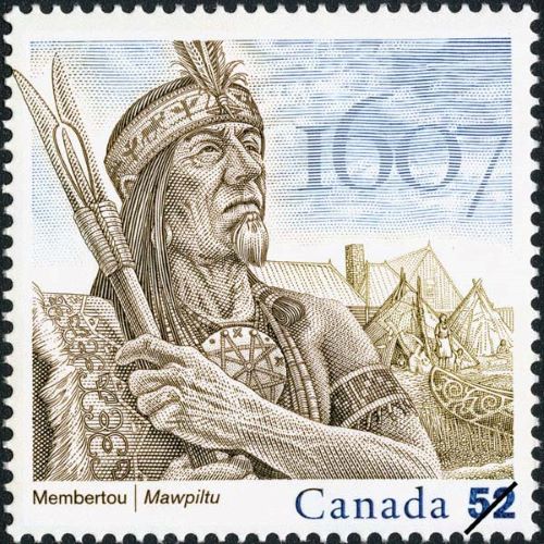
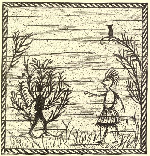
When the first Europeans began to explore the Gulf of Maine, the coast was inhabited by a well-established, populous society that had lived there for over 12,000 years. They recognized themselves as the Wabanaki and their land as Wôban-aki, which signifies the People of the Dawnland, the First Light, or simply of the East. Spanning the geography of Maine, the Wabanaki were composed of three distinct Algonquian nations, first recognized by Champlain in 1607: the Souriquois, Etchemins, and Armouchiquois.

The Souriquois were located in the northern corner of Maine, Nova Scotia, New Brunswick, Prince Edward Island, Newfoundland, and on the Gaspé Peninsula of Quebec. The Souriquois were hunter-gatherers who obtained most of their sustenance from the sea.

The Etchemin were located along the central coast of Maine in the woodlands between the Kennebec and St John Rivers. They were flanked on their northeast by the Souriquios and to their southwest by the Armouchiquois.  The Etchemins can be further divided into two groups: the Eastern Etchemins, who allied with the Souriquois and were located east of the Narraguagus River, and the Western Etchemins, who allied with the Armouchiquois and ranged along the coast and into the forested hinterland from the Narraguagus to the Kennebec River (Hoffman, 1955). This separation is controversial (see Snow, 1968 and 1978).

The Western Etchemin were composed of corn-growing villagers who inhabited the Kennebec Valley and areas to the south. The Eastern Etchemin were comprised solely of migratory foraging bands that ranged the coastal waters and vast woodlands east of the Kennebec.

The Armouchiquois ranged from western Maine to Cape Cod and comprised several corn-growing groups, which came to be known as the Abenaki, Penacook, Massachusett, and Wampanoag.  They called themselves “alnamback,” or “real people” (Haviland, 2017).

Champlain did not give the origins of the names he gave the Indigenous people, but conjectures have been made (Haviland, 2017). The word ‘Etchemin’ is believed to be either a French alteration of an Algonquian word for canoe or a translation of ‘skidijn’, the native word for people. ‘Souriquois’ was a French term meaning ‘saltwater men. ‘Armouchiquois ‘ was a French corruption of the Souriquois word ‘Alemousiski ‘, which meant ‘land of the little dog ‘. This term was intentionally derogatory, reflecting the power dynamics between the Souriquois and Armouchiquois. Their name for themselves was U’nu’k, meaning humans or people.

Maine’s evolving ethnicity

Over the 17th century, the way European’s recognized the Indigenous People of Maine would significantly evolve. The term “Armouchiquois” would quickly disappear, while the labels “Etchemin” and “Souriquois” would endure longer but also be replaced.

The English never used Champlain’s names for the Wabanaki nations. The Souriquois would become the Micmac or Mi’kmaq, and the Armouchiquois and  Souriquois tribes would be identified by the village or watershed in which they lived.  

Wabanaki groups along the Saco River were known as the Sokokis and Pequawket (Ridlon, 1895). Along the Androscoggin or Anasagunticook River lived the Pejepscot of Brunswick, the Rokomeko of Canton Point, the Passaconaway along the little Androscoggin, and the Caughnawaga, who moved about. None of these tribes survived the Wabanaki-Euro Wars of the 17th century. Survivors from these groups joined more eastern nations or moved to the Jesuit missions of  Canada (Smith, 1949).

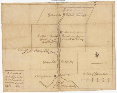
Several tribes were found along the Kennebec River. The Sagadahocs were located in an area spanning the Kennebec Valley to Merry Meeting Bay.  The Midcoast region was named after this group. The Canabas or Kennebec were centered around Swan Island, across from present-day Richmond. The grand-chief Bashaba, known to many of the early English explorers, belonged to this group. At their village of Norridgewock, several Jesuit priests, including Gabriel Droillettes and Sebastian Rale, were sent to teach the Catholic religion.  Rale would ultimately lead the Wabanaki in numerous bloody raids in one of the Euro-Wabanaki Wars.   

The Cussenocks or Cushnocs ranged near Augusta, and would interact peacefully with the Pilgrims at an early trading post they established. The Tacconets lived in the Sebasticook watershed, and along the coast from the Kennebec to the St. John lived the Sheepscot, Damariscotta, St. George River and Pemaquid tribes, collectively known as the Walinakiak or Wawenocks.  George Weymouth would abduct five Wawenocks in 1605 and take them to Sir Ferdinando Gorges and Lord Popham in England.

The Penobscot or Pentagoet lived in the Penobscot River Valley. Their great leader was Madockawando, who played a central role in two of the Euro-Wabanaki Wars. His daughter was married to the Frenchman Baron Saint-Castin, who became a powerful trader and led a series of Indian raids.  

The Passamaquoddy or Pestumokayiks lived on the coast between the Penobscot and St. Croix Rivers. North of them were the Maliseet or Malecite people.

Today, only four small federally recognized tribes exist in Maine: the Houlton Band of Maliseet Indians, the Mi’kmaq Nation, the Penobscot Nation, and the Passamaquoddy Tribe. The Passamaquoddy include two tribes, one at Motahkomikuk and another at Sipavik. 

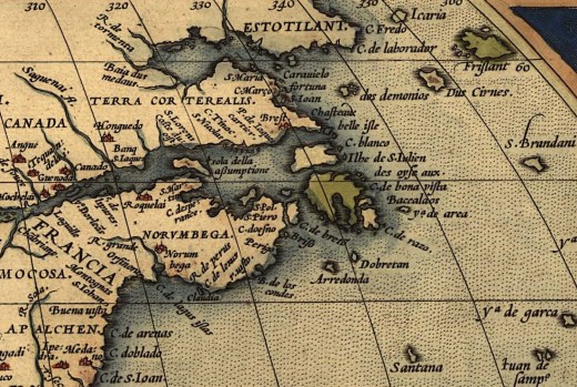
Illustration: Marc Lescarbot’s map of New France, made in 1609. Originally published in his Histoire de la Nouvelle France (Paris). Note the locations along the coast of theSouriquois, Etchemins, and Armouchiquois.

Bibliography:

Obomsawin, M. & Smith, A. (2020). The Wabanaki of the Kennebec River.  https://gradfoodstudies.org/wp-content/uploads/2024/06/39f1a-thewabanakiofthekennebecriver.pdf

Prins, H. E. L., & McBride, B. (2007). Asticou’s Island Domain: Wabanaki Peoples at Mount Desert Island 1500-2000. Acadia National Park. Ethnography Program. National Park Service.

Ridlon, G.T. (1895) Saco Valley settlements and families. historical, biogeographical, genealogical, traditional, and legendary. Author Published, Portland, Maine. 

Smith, M. J. (1949) A history of Maine, from wilderness to statehood.Falmouth Publishing House: Portland, Maine.

Snow, D. R. (1968).  Ethnohistoric baseline of the Eastern Abenaki. Ethnohistory 23(3): 291 – 306.

Snow, D. R. (1976). The ethnohistoric baseline of the Eastern Abenaki. Ethnohistory, 291-306.

The Wabanaki (2): Lifeways

There are two major groups within the Wabanaki – the Eastern Wabanaki (Etchemin and Mi’kmaq) located from Newfoundland to the Kennebec River Valley, and the Western Wabanaki (Abenaki) found between the Kennebec and Merrimack River Valley.  The Eastern Wabanaki depended solely on hunting, fishing, and gathering, while the Western Wabanaki also grew maize, squash, and beans in semi-permanent villages.

The Etchemin lived in villages in times of plenty and went through an annual cycle of migration – moving southward to seashore camps for the summer, and then northward to deep woods hunting camps in the fall and winter. They foraged in small extended families, that were part of a larger tribal community that numbered between 300-500 people. The kin groups lived on their own for most of the year, foraging in their familiar areas, but in the spring, rejoined larger kin groups at food-rich sites. Many hundreds of tribal members and visitors from distant regions would then encamp together.

“Each kin group within the small communities had its own vested interests in certain tracts of forest, stretches of rivers and lakes, peninsulas, seashores, and coastal islands sustaining them … Successive generations of Indian hunters, fishers, and gatherers periodically returned to these familiar places where they could hunt, fish, and gather for some time, before moving on to another place to set up camp. With kinship ties, including intermarriage, between neighboring families, they would have operated in close association, and their foraging territories probably overlapped “ (Prins and McBride, 2007:pgs. 17-18).

The Wabanaki hunted and foraged widely. They used dogs to chase their prey, especially moose, deer, and caribou. They also hunted bears, beavers, otters, gray seal, waterfowl, and other birds. “They tapped the sweet sap of the maple tree and harvested greens (young ferns or fiddleheads, etc.), wild fruits (strawberries, etc.), nuts (chestnuts, etc.), seeds (wild rice, etc.) and edible roots and tubers (groundnuts, etc.). Etchemin families dug clams in the mudflats. Other shellfish were also eaten, including lobster, some being 20 pounds in weight … Etchemins used harpoons to take seals, porpoise, and sturgeon, and special three-pronged fish spears to catch salmon, trout and bass. At night, they lured the fish with torches of burning birchbark from their canoes. This way, a man could spear up to 200 fish during one trip. In addition to using nets, hooks and lines, Etchemins caught a variety of fish in weirs made of wooden stakes placed in a shallow stream or small tidal bay.” (Prins and McBride, 2007 – pgs. 21-22).

Wabanaki crafted their tools, clothes, and implements from available resources. They carved harpoons, needles, awls, and fishing hooks from animal bones. They built seaworthy canoes of birch bark, with a white cedar frame sewn with black spruce root, sealed with spruce gum or pitch, and lined with Northern white cedar slats. They used chipped stone to craft arrowheads, knives, scrapers, and heavy woodworking tools. They made ceramic cooking pots from fired clay mixed with crushed rock grit or shells. These pots were decorated with a variety of intricate designs that changed over time. They used sweetgrass to weave baskets. Their clothing was made of animal hides and furs, mostly moose, caribou, beaver, bear, and seal.

The Wabanaki lived in tent-like, birchbark homes called wigwams, which means “home” in Algonquian-based languages. They were cone-shaped, with a hole in the top to let out smoke from an internal fire.  The interior was blanketed with large deer, moose, and bear pelts. Animal hides hung over the doorway to keep the elements out.

The Wabanaki leaders were usually chosen from a small group of men belonging to families believed to possess supernatural powers. The ”sokom” (sagamore or chieftain) kept his position until he died, or the people lost confidence in him. A new tribal leader was elected from among the leading family heads, but most were selected from the same respected family as the deceased chief. The sokom mediated disputes and decided on foraging territories, but all decisions were subject to the consensus of family heads and elders of his community. Most major decisions were made during the springtime gatherings. 

Illustration: An engraving made by Mattheüs Merian (1593-1650) of Wabanaki hunting on Mount Desert Island. From Sir Ferdinando Gorges 1622 “Brief Relation of the Discover and Plantation of New England.

Bibliography: Prins, H.E.L and McBride, B. (2007) Asticou’s Island Domain: Wabanaki Peoples at Mount Desert Island 1500-2000. Northeast Regional Ethnography Program, National Park Service, Boston, Massachusetts.

The Wabanaki (3): Winter hunts

The Jesuit Relations are filled with references to the hardships incurred by the priests who accompanied Amerindians on their long winter hunts. However, winter was actually a welcome time for the Wabanaki of Maine. The interior hunting grounds were rich sources of wild sustenance, with moose being the most important and their favorite. Stable, deep snows facilitated successful moose hunting by family groups of eight to ten along routes that sometimes exceeded three hundred miles. The Wabanaki had great respect for the severity of the cold and the potential for hunger, but were also confident of their ability to survive in the worst conditions.

In late fall each year, the family bands would head upriver in their birchbark canoes, which could hold up to 10 people. When the rivers began to freeze, they left their canoes behind and moved ahead on foot, and when the snow got really deep, they used snowshoes to travel and pulled toboggans with their household goods. Their snowshoes were made of white ash or beech and held together with cords made of guts or hide.

They would camp at promising hunting sites near water, first building a fire, and then constructing a wigwam. As the Jesuit missionary Father Baird described:

The women would go to the woods and bring back some poles, which were stuck into the ground in a circle around the fire, and at the top were interlaced into a pyramid, so that they came together directly over the fire, for there is the chimney. Upon the poles, they throw some skins, matting, or bark. At the foot of the poles, under the skins, they put their baggage. All the space around the fire was strewn with leaves of the fir tree, so they would not feel the dampness of the ground; over these leaves were often thrown some mats, or sealskins as soft as velvet; upon this they stretch themselves around the fire with their heads resting upon their baggage; And, what no one would believe, they are very warm in there around that little fire, even in the greatest rigors. (Thwaites, 1898, p. 75)

Other Jesuits would describe these wigwams as filthy, crowded, and smoke-filled, but to the Wabanaki, they must have felt snug and welcoming. Certainly, a respite from the bitter cold.

Hunting for moose became the Wabanaki’s primary focus. In the winter, the moose remained in the uplands where Wabanaki hunted, while the white-tailed deer moved to the lowlands where the English settlers lived. White tailed deer were hindered by twelve inches of snow and immobilized by twenty inches unless the surface was frozen and could hold their weight.  Moose, with their much longer legs, could handle deep snow much better, although they were sufficiently slowed to be vulnerable to Wabanaki hunters on snowshoes.

With each step, a moose’s legs punched through the frozen surface of the snow, which slowed it down and sometimes lacerated its skin. Snowshoes kept Wabanaki hunters from sinking, and over the course of a long chase, they could outperform the fatigued, wounded, and harried animal. If the conditions were right, Native hunters caught up to a moose “sometimes in half a day, sometimes a whole day,” or, in other words, after many miles. For the “ardent Hunter who is following on snowshoes,” such hunts required both agility and endurance. As Josselyn noted, only “the young and lustie Indians” could keep pace with the moose. Dogs helped too, enjoying the same advantage atop a frozen snowpack. On dry ground, moose towered over humans, with the back of a bull often seven feet off the ground. But atop the surface of the snow, Wabanakis could sometimes be even taller and make the kill from above with their lances. (Wickman, 2015, p. 68).

A moose yielded a considerable amount of meat and much rawhide for clothing and moccasins. The Wabanaki cooked and ate all parts of the moose, including the heart, tongue, snout, kidney, liver, and intestines, and the cacamo, or moose butter. This was produced by pounding the bones to a powder after sucking out the marrow, then boiling it to recover the fat, which bubbled to the surface. They could get five to six pounds of grease per moose, which they ate directly or used as provisions on a hunt. Some of the meat was smoked and dried for long-term storage and shared with other family bands in need. It served as subsistence insurance for a wide network of hunting bands scattered across the forest (Whickham, 2015).

Some scholars have suggested that the long winter treks of the Wabanaki were due to the scarcity of game, forcing them to move continually in search of food. However,  the long expeditions

actually signaled virtuosity in winter travel—not scarcity-induced wanderings—and registered the strong positive value they placed on the winter hunt … evidence from the early eighteenth century indicates that moose, bears, and beavers thrived throughout much of Dawnland, despite diminishing populations near the coast.

John Gyles, held captive by a Maliseet band after a 1689 raid on Pemaquid, Maine, witnessed firsthand Wabanakis’ persistence in pursuing moose. They continually moved “up the country after moose,” and concluded on the northern end of the Gaspé Peninsula, some four hundred miles away from the site of the raid. Gyles’s captors sought to comfort him by promising a rich hunt: he later recalled that his masters “would often encourage me, saying in broken English, ‘By-by, great deal moose.  (Wickman, 2015, pp. 70 – 71)

Illustration: A Maine Moose in winter.

Bibliography:

Prins, H. E. L., & McBride, B. (2007). Asticou’s Island Domain: Wabanaki Peoples at Mount Desert Island 1500-2000. Acadia National Park. Ethnography Program. National Park Service. 

Thwaites, R. G. (ed) (1898) The Jesuit Relations and Allied Documents, vol. 3. Acadia 1611 – 1616. Burrows Bros. Co., Cleveland

Wickman, T.  (2015) “Winters Embittered with Hardships”: Severe Cold, Wabanaki Power, and English Adjustments, 1690–1710. The William and Mary Quarterly 72: 57–98.

The Wabanaki (4): Leadership structure

Throughout the French and Indian Wars, the English operated on a misconception. They were not fighting an organized hierarchical enemy, but rather numerous, independent groups who often did not cooperate.  

The Wabanaki lived in dispersed bands of extended families for much of the year, coming together during the spring and summer at seasonal encampments along rivers or the seacoast.  They foraged in small extended families of a larger tribal community that numbered 300 to 500 people. The kin groups lived independently for most of the year, foraging in their familiar areas, but in the spring, they rejoined larger kin groups at food-rich sites. Many hundreds of tribal members and visitors from distant regions would then encamp together.

“Each kin group within the small communities had its own vested interests in certain tracts of forest, stretches of rivers and lakes, peninsulas, seashores, and coastal islands sustaining them … Successive generations of Indian hunters, fishers, and gatherers periodically returned to these familiar places where they could hunt, fish, and gather for some time, before moving on to another place to set up camp. With kinship ties, including intermarriage, between neighboring families, they would have operated in close association, and their foraging territories probably overlapped” (Prins & McBride, 2007, pp. 17-18).

The Wabanaki leaders were usually chosen from a small group of men belonging to families believed to possess supernatural powers. The ”sokom” (sagamore or chieftain) kept his position until he died, or the people lost confidence in him. A new tribal leader was elected from among the leading family heads, but most were selected from the same respected family as the deceased chief. The sokom mediated disputes and decided on foraging territories, but all decisions were subject to the consensus of family heads and elders of his community. Most major decisions were made during the springtime gatherings. 

“While each tribal group had recognized leaders, or sakoms (“sagamores”), their political organization was largely a democracy. Heads of larger kin-groups sharing a foraging domain participated in important political discourse concerning internal and external affairs, and decisions concerning the common wealth were based largely on consensus among members. Within the tribal community, one family head would be recognized as a first among equals and acknowledged as the region’s headman or district chief “ (Prins and McBride, 2007, p. 34). Some powerful super chiefs, like Bashaba or Makawando, came to the forefront and led many groups to war, but only through persuasion and admiration. There was no formal leadership structure.

 While Squando and a group of allies were the first to rage and start King Philips War in 1675, many other groups were reluctant to abandon peace. There was by no means a consensus on how to react to the uptick in hostilities. Bilodeau (2013, p. 13) suggests, “Those in favor fought for at least four reasons. Many allied with the sachem Squando were bent on revenge for the death of his infant son. Others were incensed at English demands for Indian disarmament. Yet others harbored resentment over decades-old problems related to the fur trade. Finally, some listened attentively to envoys from King Philip and wanted to engage the English in what might be understood as a pan-Indian war on New England. And, of course, many Indians were motivated by a combination of these issues. But other Indians remained unconvinced. They pushed for peace, hoping to maintain trade for necessities and skirt the inevitable problems that come from warfare – death, disease, and migration from harm’s way.”

Even though many Wabanaki groups remained peaceful during phases of the French and Indian Wars, the English largely overlooked these nuances and viewed the Wabanakis as a single, monolithic entity. Violence from any group meant all Wabanaki were at war.  This confusion would have a profound impact on the war’s course.  

The English would retaliate against the Wabanaki as if they all operated under a central authority. No matter how small, any affront warranted retaliation against all Wabanaki encountered.  In their holistic attempts to crush the Wabanaki in Maine, the English ultimately catalyzed even the most peaceful tribes to join the war. Because the Wabanakis had no centralized army and conducted the war through small, sporadic raids, the English had no single, identifiable target to wage war against.

Illustration: Engraving of Mattheüs Merian (1593-1650) depicting Wabanaki hunting on Mount Desert Island from Sir Ferdinando Gorges 1622 “Brief Relation of the Discover and Plantation of New England”

Bibliography:

Bilodeau, C. J. (2013). Creating an Indian Enemy in the Borderlands: King Philip’s War in Maine, 1675-1678. Maine History 47(1): 10-41.

Hancock, J. F. (2025). John Cabot to Henry Hudson: Early European Arrivals in Mid-Atlantic and Northeastern North America. McFarland and Company.

Prins, H. E. L., & McBride, B. (2007). Asticou’s Island Domain: Wabanaki Peoples at Mount Desert Island 1500-2000. Acadia National Park. Ethnography Program. National Park Service.

The Wabanaki (5): World view

The Wabanaki concept of land ownership differed significantly from that of Europeans.  The Indigenous people of Dawnland did not believe that people could own land, whereas 16th- and 17th-century European colonists considered owning land to be a God-given right. According to Genesis 1:28: 

“God blessed them and said to them, Be fruitful and multiply; fill the earth and subdue it. Rule over the fish in the sea and the birds in the sky and over every creature that moves on the ground.”

To the Wabanaki, the land was a sentient being. It was their mother, a close relation to be cared for and respected. As Ian Saxon (2019) describes:

“In conferences with English leaders, Wabanaki speakers said they “belonged” to rivers or stretches of land. In contrast, early modern English people “belonged” to towns or other human communities rather than the land itself … The Wabanaki} worldview, which recognized they shared the land with animals and other people. As a result, the Wabanaki managed available resources in cooperation with animals and otherworldly beings rather than wielding domination over them, as European Christians believed their God had directed them to do in the book of Genesis. Instead, the Wabanaki lived in what scholars call an “animate” world, in which people, animals, and even some nonliving things had a spirit or force, and they were conscious of sharing a network of relations with humans and others.” 

The Wabanaki would find the Europeans’ concept of land confusing. Lisa Brooks(2019) suggests:

“When English people arrived in Wabanaki territory, including the land now known as Maine, Wabanaki leaders worked to incorporate settlers into their social and ecological networks, to create responsible relationships, and to “make kin” and alliances with their guests. English guests all too often misinterpreted such hospitality, misunderstanding the obligations that accompanied the privilege of sharing space. The written language of the English, as compared with wampum protocols and verbal agreements of the Wabanaki, led to confusion and to deliberate dispossession. Even as the Wabanaki people strove to incorporate settlers into their Indigenous cultural and economic systems, the settlers sought their signatures and consent for land ownership on finite political documents.”

Traditional ecological knowledge

Because of their long and intimate association with nature, Wabanaki possessed what has been called “traditional ecological knowledge” (TEK). Their society had acquired a cumulative body of knowledge, practice, and belief that reflected the tight interrelationships among all living beings (including humans) and with their environment. TEK evolved as the Wabanaki adapted to their environs, and the knowledge gained was handed down through generations. 

The Wabanaki learned which cultural practices would sustain their communities over the long term. The seasonal cycles of scarcity and abundance that they regularly faced had taught them that overexploitation of the habitat they were part of would result in dire consequences for their own survival.

Brooks and Brooks (2010) describe how the “Wabanaki people developed a matrix of stories, ceremonies, and subsistence practices that enabled long-term survival in the places to which they belonged … [They learned] individual action can have tremendous ramifications for the whole, and therefore individual responsibility to the community, including one’s human and non-human relations, is held in utmost.”

One of the most important roles of the Sagamore was to ensure that resources were distributed equally among the group.  “The sachems, generally the most successful providers, acted as redistributive agents. They not only created a surplus but assured its fair division”. The most successful planters, hunters, and fishers were valued for their ability to contribute to the whole; their “skills and hard work were rewarded, not with greater wealth, but with greater responsibility, and respect within one’s family network”.

Sagamores were also responsible for distributing resources between villages through trade. During times of scarcity, warfare could arise if this system failed. Regular ceremonial council meetings helped avoid such instances, “cementing familial relationships and ensuring that resource rights and responsibilities were clearly defined”.  

When the English moved into Wabanaki lands, the Wabanaki tried to incorporate them into their reciprocal networks, but the English were rarely cognizant of how they fit into this system. They viewed agreements as giving exclusive title, not sharing relationships. “[English] settlers and fishermen sought to take advantage of the abundant resources of the region, amassing as much fish and wood as possible to ship overseas to transatlantic markets. Conflicts arose when European traders and settlers failed to participate in the local system of distribution, conservation, and “ritualized reciprocal exchange.” Wabanaki people were not interested in capital formation for its own sake. Rather, they recognized economic success in terms of the security it achieved for the community as a whole.” However, this economic value system came into direct conflict with a European system that emphasized accumulation of goods, protection of property and wealth, and the rights of the sovereign, corporation, or individual to amass as much resources as possible for their own use and for distribution overseas …”

The ever-increasing English assertion of sovereignty over the region and its resources would ultimately lead to open warfare in the late seventeenth century,

Illustration: Wabanaki Hunting on Mount Desert Island, 1622. Author: Matthäus Merian (1592-1650). Source: Public domain, via Wikimedia Commons.

Bibliography:

Berkes, F. (1999) Sacred ecology: Traditional ecological knowledge and resource management. Taylor & Francis: Philadephia

Brooks, L. (2019-2020). Holding Up the Sky: Wabanaki People, Culture, History, and Art. Maine Memory Network.

Brooks, L. T. and Brooks, C. M. (2010) The Reciprocity Principle and Traditional Ecological Knowledge: Understanding the Significance of Indigenous Protest on the Presumpscot River. International Journal of Critical Indigenous Studies. 3(2):11-28. p. 13.

Saxon, I. (2019). Properties of Empire: Indians, Colonists, and Land Speculators on the New England Frontier. New York University Press, p. 13.

The Wabanaki (6): The Mawooshen Confederation

In about 1600, when the French and English were making their first contact with Maine, what had been mostly peaceful interactions between the Tarrentines and the other coastal people erupted into great violence. To defend themselves, the Etchemin west of the Kennebec and the southern Armouchiquois allied and formed the Mawooshen Confederation. It would encompass a 120-mile stretch of Maine from the Narraguagus River in the northeast to the Mousam River (at Kennebunk). A grand chief, Bashaba of Penobscot, would head the confederation.

A remarkable document describing Mawooshen was produced in England in 1605 or 1606 by Ferdinando Gorges, who hosted and interviewed the sagamore Tahánedo and the other four Etchemin abducted by George Waymouth. The original document does not exist, but a version entitled “Description of the Country of Mawooshen” was published unattributed in 1623 by Samuel Purchas in his Hakluytus Posthumus or Purchas His Pilgrimes.   

The Country of Mawooshen describes the area as a series of nine river drainages extending from Mount Desert Island on the east to the Saco River on the west. Along each river are outlined the major villages, the number of men in each, and the most critical sagamores. Overall, Purchas lists 21 villages and 23 sagamores. He suggests there were a total of 1,238 homes and 3,000 warriors, yielding an estimated total population of about 10,000 (Snow, 1976).

As described by Purchas:

“In Mawooshen it seemeth there are nine Rivers, whereof the first to the East is called Quibiquesson [Frenchman Bay/Blue Hill Bay-Union River]; on which there is one Towne, wherein dwell two Sagamos or Lords, the one called Asticou,the other Abermot. In this Towne are fiftie houses, and 150 men. The name of which Towne is Precante [Ellsworth/Sorrento?]; this River runneth farre up into the Mayne, at the head thereof there is a Lake of great length and breadth; it is at the fall into the Sea tenne fathoms deepe, and halfe a mile over. The next is Pemaquid [lower Penobscot], a goodly River and very commodious all things considered; it is ten fathoms water at the entrance, and fortie miles up there are two fathoms and a halfe [15 feet] at low water; it is halfe a mile broad, and runneth into the Land North many daies journey: where is a great Lake of 18 leagues [54 miles] long and foure [12 miles] broad. In this Lake are seven great Ilands: toward the farthest end there falleth in a River, which they call Acaconstomed, where they passe with their Boates thirtie daies journey up, and from thence they goe over Land twentie daies journey more, and then come to another River [St. Lawrence], where they have a trade with Anadabis or Anadabion [Anadabijou, the Montagnais grandchief] with whom the Frenchmen have had commerce for a long time [at Tadoussac]1603]. Neere to the North of this River of Pemaquid [Penobscot] are three Townes: the first is Upsegon [Bangor], where Bashabes their chiefe Lord doth dwell. And in this Towne are sixtie houses, and 250 men, it is three daies journey within the Land. The second is Caiocame; the third Shasheekeing. These two last Townes are opposite one to the other, the River dividing them both, and they are two daies journey from the Towne of Bashabes. In Caiocame dwelleth Maiesquis, and in Shasheokeing Bowant, two Sagamos, subjects to Bashabes. Upon both sides of this River up to the very Lake, for a good distance the ground is plaine, without Trees or Bushes, but full of long Grasse, like unto a pleasant meadow, which the Inhabitants doe burne once a yeere to have fresh feed for their Deere.Beyond this Meadow are great Woods, whereof more shall be spoken hereafter. The River of Pemaquid is foure dayes journey from the mouth of Quibiquesson [Mount Desert Islandwaters]. . . . The River Shawakatoc [Saco] . . . is the Westermost River of the Dominions of Basshabez, and  Quibiquisson the [Eastern] most.“ (Prins and McBride, 2007, pp. 56-57)

Most of the locations outlined in Purchas were confirmed in a trip of Captain John Smith to the region in 1614, guided by none other than Tahánedo. As described by Baker (2004, p. 80): “Captain John Smith, a visitor to the coast of New England in 1614, clearly laid out the bounds of Bashaba’s lands and powers. He described the region from the Penobscot to the Sagadahoc as the land of Bashaba. He then added that ‘‘To these are allied in confederacy, the Countries of Aucocisco [Casco Bay], Accomynticus [Agamenticus], Passataquack [Piscataqua], Aggawom [Ipswich] and Naemkeck [Salem].’’ Here Smith essentially describes the territory of the Almouchiquois and indicates they were allies of Bashaba and the western Etchemin”.

The center of Mawooshan was at the grandchief’s great tribal rendezvous site at Pentagoet (Castine), at the mouth of the Bagaduce in eastern Penobscot Bay. In 1615, this spot became the location of a major fur trade post and stronghold that would be fought over by the French, and English, desiring the furs, moose hides, sealskins, and other goods that Wabanakis had to offer (Prins and McBride, 2007, p. ii).

Illustration: Symbol of the Wabanaki Union of Tribes, still in use. It was originally embroidered onto the ceremonial clothing of sakoms. Frank Speck (1927) Symbols In Penobscot arthttps://en.wikipedia.org/wiki/Wabanaki_Confederacy#/media/File:Wabanaki_Union_Symbol.png

Bibliography

Baker, E. W. (2004). Finding the Almouchiquois: Native American Families, Territories, and Land Sales in Southern Maine. Ethnohistory, 51(1),  73-100.

Purchas, S. (Ed.) (1907) The Description of the Country of Mawooshan Discovered by the English in the Yeere 1602. In: Hakluytus, Posthumus, or Purchase his Pilgrims (Glasgow: J. MacLehose 8c Sons), vol. 19, pp. 400-05

Prins, H. E. L., & McBride, B. (2007). Asticou’s Island Domain: Wabanaki Peoples at Mount Desert Island 1500-2000. Acadia National Park. Ethnography Program. National Park Service. 

The Wabanaki (7): Tarrentine Wars

About the time the English and French began to explore the northern coast of Atlantic America,  what had been mostly friendly trading interactions between the Tarrentines and the other coastal New England nations turned to violence. The Etcheman west of the Kennebec (Penobscot, Kennebec) and the southern Almouchiquois would ally, form the Mawooshen Confederation, and become the sworn enemies of the Tarrentines.

The arrival of French fur traders in the St. Lawrence Valley stimulated a crisis among the Indigenous nations that lasted over 25 years. A growing scarcity of fur-bearing animals intensified inter-tribal competition, and a major power imbalance arose when the French provided the Tarrentines with firearms.

While there are few European eyewitness reports of these battles, Champlain and Lescarbot published numerous accounts of the Indigenous participants. During the Champlain and Poutrincourt excursions along the Maine coast, Lescarbot writes that in 1606 at the village of Chouacoet near Saco Bay, Almouchiquois chiefs Marchin and Onemechin “brought Monsieur de Poutrincourt a Souriquois [Mi’kmaq] prisoner, and therefore their enemy, whom they freely handed over to him” (Biggar, 1928: 99).

During the same visit, Champlain told of two Sagamos who came there from the east in their own shallot, an Etchemin named Messamouet and a Souriquios [Mi’kmaq] named Secoudon. These two Tarrentine had come to trade with French merchandise gained by barter, even though they were traditional enemies of the Almouchiquois. After a long oratory by Messamouet, he made presents of kettles, axes, knives, and other manufactured articles, to which Onemechin gave him back Indian corn, squashes, and Brazilian beans. This produce did not altogether satisfy Messamouet, “who departed much displeased because he had not been suitably repaid for what he had given them, and with the intention of making war upon them before long…” (Bigger, 1922: 395-396). After this encounter, Secoudon stayed with Champlain’s expedition while Messamouet returned to Nova Scotia.

During Champlain’s return voyage, as he passed Great Wass Island on the coast of Maine, a group of Eastern Etchemin informed Secoudon that a Mi’kmaq chieftain named “Iouaniscou and his companions had killed some other [Armouchiquois] and carried off some women as prisoners, and that near Mount Desert Islandthey had put these to death.” (Biggar, 1922: 426). When Champlain dropped Secoudon off at St. Croix after the voyage, Champlain reported that the Etchemin chief returned with scalps he had obtained at Cape Cod, although the details of how these were obtained are not given.

In the autumn of 1606, the murders of Iouaniscou were avenged by the Etchemin with the murder of the Mi’kmaq Panonias, who had guided Champlain the previous summer. He was killed by Mawooshen warriors in the Penobscot Bay area.  After his death, the Eastern Etchemin chief  Ouagimout of  Passamaquoddy  Bay asked  Bashaba, the grand chief of Mawooshen, for Panonias’ body. The body was then delivered by Ouagimout, wrapped in moosehide, to a Mi’kmaq encampment near Port Royal. Membertou, Panonias’s father-in-law and grand chief, welcomed Ouagimout and presented ritual gifts of mourning to Panonias’ relatives. Panonias was then buried on an island near Cape Sable.

In response, Membertou, with 500 warriors, attacked the town of Chouacoet, that Champlain had previously visited on July 1607, killing twenty people, including two grand chiefs, Onmechin and Marchin.  The Tarrentine also suffered losses in this raid, including Chief Ouagimout of Passamaquoddy Bay, who was grievously wounded, and Chief Secoudon. who was killed.   

Membertou conducted his attack as a surprise offensive. He appeared before the Abenakis unarmed, pretending that he wanted to negotiate, and then, he and his men seized hidden weapons and attacked. Membertou’s force was composed of Mi’kmaqs from his band and Messamouet’s, along with Eastern Etchemins from the St. John River under Chief Secoudon and from the Passamaquoddy Bay area under Chief Ouagimout (Prins and McBride, 2000).

Thus began what has been called the Tarratine or Mi’kmaq Wars, where bands of Tarrentine warriors in fleets of canoes and shallops began raiding Mawooshen villages, killing people and taking captives along with corn, furs, and moose hides. These wars culminated with the slaughter of the Mawooshen grand chief Basaba in 1615. This was followed by the great plague (“Great Dying’) of 1616-19. An estimated 2,500 out of 7,500 eastern Etchemins died, while as many as  9,000 out of 12,000 western Etchemins perished. The Almouchiquois must have also suffered staggering casualties. 

Even after the collapse of the western Etchemin, Mik’maq raids against the Amouchiquois continued until as late as 1631. However, the Tarrentine entrepreneurs’ fortunes declined rapidly after Europeans appeared in the Gulf and began trading directly with local fur producers.

Illustration: Alan Syliboy’s portrait of Grand Chief Henri Memberton that was presented to Queen Elizabeth the Second on 28 June 2010 by Grand Chief Benjamin Sylliboy and placed on permanent display in Government House Halifax.

The Wabanaki (8): The Super Chiefs – Bashaba and Membertou

When the Europeans first arrived in the Gulf of Maine, there were two Wabanaki super chiefs living across the Gulf from each other – the western Etchemin Bashaba, who resided on the Penobscot near Bangor, Maine, and the Souriquois (Mi’kmaq) Membertou, who lived in western Nova Scotia near Port Royal. Bashaba led the Mawooshan Confederacy encompassing a 120-mile stretch of Maine from the Narraguagus River in the northeast to the Mousam River (at Kennebunk). Membertou was the head of the rival Tarentines, an amalgamation of the Souriquois of Nova Scotia and their neighboring eastern Etchemin (Today’s Passamaquoddy and Maliseet) across the Bay of Fundy.

Bashaba

Many early European reports of encounters with Bashaba confirm his eminence over other Wabanaki leaders. Near Bangor, Maine, in 1605, Champaign met with him, another local sagamore named Cabhis, and 30 of their followers.  The meeting went smoothly, and strong interests were expressed for cooperation and alliance. 

A marvelously detailed description of Mawooshen was written in England in 1605 or 1606 by Ferdinando Gorges, who, with George Popham, hosted five Etchemin that had been abducted from the coast of Maine by George Waymouth. The original document does not exist, but a version entitled “Description of the Country of Mawooshen” was published unattributed in 1623 by Samuel Purchas. In it, Mawooshen is described as covering a series of nine river drainages extending from Mount Desert Island on the east to the Saco River on the west. Along each river are outlined the major villages, the number of men in each, and the most critical sagamores. Overall, 21 villages and 23 sagamores fell under Bashaba’s jurisdiction.

This document was carried to Maine by the settlers of the Popham Colony at Sagadahoc in 1607 to serve as a travel guide. The settlers of this ill-fated colony avoided direct contact with Bashaba, but they had extensive interactions with his son Tahánedo, one of the original abductees of Waymouth.  Tahánedo had gotten back to Maine in 1606, serving as a guide for Thomas Hanhan, who explored the rivers and harbors of the Gulf of Maine.    

Jesuit missionary Father Pierre Biard met Bashaba near Castine, ME, in November 1611 at a gathering of about 300 Etchemin. In his History of New France, he reported, “The most prominent Sagamore was called Betsabes, a man of great discretion and Prudence.” 

Captain John Smith also interacted with Bashaba in 1614 through Tahánedo.  In his Voyages to New England, Smith “clearly laid out the bounds of Bashaba’s lands and powers. He described the region from the Penobscot to the Sagadahoc as the land of Bashaba.”  (Baker, 2004, p 80).

Membertou

Very soon after the first fur traders arrived in the St. Lawrence River Valley in the 16th century, Membertou was recognized as a powerful representative of the Mi’kmaq. In addition to being sagamore, Membertou was also the autmoin, or spiritual leader. He “was an agent of transition: a leader with the vision and strength of character that enabled him to influence changes. He led by example, accumulating prestige, power, and influence. The Mi’kmaq became a real trading and naval force at sea.”(Sayer, 2024).

Membertou and his followers were among the first to regularly use Basque-style shallops in long-distance travel for trade. In the 1570s, he spent time in France, hosted by the major of Bayonne. When the first French expedition of the Sieur de Monts arrived in Nova Scotia in 1604, Membertou was among the first Indigenous people to greet the settlers, and he played a key role in their survival.

Membertou head of the Tarentines, became embroiled in a bloody dispute with the Mawoosen Confederation of Basaba. In the fall of 1606, a group of Etchemin plundered and killed Panoniac, a Mi’kmaq chief who had served as a guide to Champlain. In revenge, Membertou gathered 400 warriors, attacked the village of Chouacoet, near Saco, Maine, in July 1607, killing twenty people and two sagamos. The crafty Membertou was unarmed when he appeared before the Armouchiquois, feigned the wish to negotiate, and then, as the lawyer, adventurer Lescarbot describes in La Defaite des sauvages, “suddenly he and his men seized the weapons he had set out” and attacked. Many Abenaki chiefs died, whereas Membertou’s party incurred not a single loss. (Béreau, 2020). Bashaba was not part of this battle and survived until 1615 when a group of Tarentines ambushed him.

In 1610, Membertou entered a formal alliance with the French and was the first Indigenous leader to be baptized as a Catholic. Twenty-one members of his family joined in the ceremony. Membertou was given the baptismal name of Henri, after the late king of France.

Membertou died of dysentery later in 1610, supposedly at over one hundred years old, in one of the great epidemics that raced through the Indigenous people of the Northeast.   

Illustration: Canadian postage stamp of Membertou

Bibliography:

Baker, E. W. (2004) Finding the Almouchiquois: Native American Families, Territories, and Land Sales in Southern Maine. Ethnohistory, 51 (1): 73 – 100.

Béreau, S.  (2020). Membertou (baptized Henri). Dictionary of Canadian Biography, Vol. 1, University of Toronto/Universite Laval. http://www.biographi.ca/en/bio/membertou_1E.html.

Grant, W. L. (Ed.) (1907). Voyages of Samuel de Champlain 1604 – 1618. Charles Scribner’s Sons.

Prins, H. E. L., & McBride, B. (2007). Asticou’s Island Domain: Wabanaki Peoples at Mount Desert Island 1500-2000. Acadia National Park. Ethnography Program. National Park Service. 

Purchas, S. (Ed.) (1907) The Description of the Country of Mawooshan Discovered by the English in the Yeere 1602. In: Hakluytus, Posthumus, or Purchase his Pilgrims (Glasgow: J. Maclehose 8c Sons), vol. 19, pp. 400-05

Sayer, B. (2024) MessamouetHistoric Nova Scotia. https://historicnovascotia.ca/items/show/189.

The Wabanaki (9): Children of Gluskap

Long before the Europeans appeared on Maine’s shores, the Wabanaki had lived and prospered on its rivers, lakes, and woods for many thousands of years. From generation to generation, their long and rich history was passed down through oral tradition.

The Wabanaki’s worldview was shaped by the many creation stories featuring their mythological ancestor, Gluskap. In these stories, Gluskap taught the Wabanaki how to live in harmony with and respect the land, water, and all living things.

As described by Frank Speck, 1935, p. 10): “Penobscot mythology credits Gluskap with some twenty major achievements for the benefit of man, to wit: distributing over the world the game animals, food, fish, hares and tobacco; renewing the warmth of summer; protecting the eagle above who regulates daylight and darkness; moderating the destructive force of the wind; tempering the winter; bringing he summer north; reducing giant animals to a harmless size; domesticating the dog; clearing obstructions from the portages along the routes of hunting and travel; smoothing out the most dangerous waterfalls; creating the whole Penobscot river system; moderating the power of fire; making burns curable; creating sweetgrass; and serving as a source of power for those who come  to his distant dwelling with their troubles. His benefits to mankind reach a climax in the mission he allocates to himself: to watch over his people and return to the land at some unknown date. Against this time, he is preparing food and armaments to save them in a crisis. By inference the Penobscot are also inclined to attribute to him the origin of their arts and inventions.

In these stories, the Wabanaki were reminded of their place in the natural environment and their relationships with the land.

The story of Gluskap’s origin as Klose-kur-beh, “The Man from Nothing,” is beautifully told in  Joseph Nicolar’s book, The Life and Traditions of the Red Man. Nicolor was a Penobscot tribal governor and a direct descendant of the great Wabanaki leader Madockawando, who lived in the 1600s, in a time when the Penobscot were still numerous and powerful.

Nicolar  (1993, pp. 7- 8) offered this detailed telling of Gluskap’s own mythic beginnings:

“KLOSE-KUR-BEH, “The Man from Nothing,” first called the minds of the “Red Children” to his coming into the world when the world contained no other man, in flesh, but himself. When he opened his eyes lying on his back in the dust, his head toward the rising of the sun and his feet toward the setting of the sun, his right hand pointing to the north and his left hand to the south. Having no strength to move any part of his body, yet the brightness of the day revealed to him all the glories of the whole world; the sun was at its highest, standing still, and beside it was the moon without motion, and the stars were in their fixed places, while the firmament was in its beautiful blue.

While yet his eyes were held fast in their sockets, he saw all that the world contained. Besides what the region of the air revealed to him, he saw the land, the sea, mountains, lakes, rivers, and the motion of the waters, and in it he saw the fishes. On the land were the animals and beasts, and in the air the birds. In the direction of the rising sun, he saw the night approaching. While the body clung to the dust, he was without mind, and the flesh without feeling. At that moment the heavens were lit up, with all kinds of bright colors most beautiful, each color stood by itself, and in another moment every color shot a streak into the other, and soon all the colors intermingled, forming a beautiful brightness in the center of the heavens over the front of his face. Nearer and nearer came the brightness toward his body until it got almost to a touching distance, and a feeling came into his flesh; he felt the warmth of the approaching brightness, and he fell into a deep sleep. The wind of the heavens fanned his brow, and the sense of seeing returned unto him, but he saw not the brightness he beheld before, but instead of the brightness, a person like unto himself, standing at his right hand, and the person’s face was toward the rising of the sun …

Immediately after the passing of the lightning over his body, a sense of thought came unto him. The first thought that came unto him was, that he believed the person was able to bring strength unto him, and the “Great Being” answered his thought saying these words: “Thou doest well believing in me, I am the head of all that thou beholdest, and as thou believest, arise from thy bed of dust, and stand on thy feet, let the dust be under thy feet, and as thou believest, thou shalt have strength to walk.” Immediately strength came unto him, and he arose to his feet, and stood beside the “Great Being”…

Then, by command of the “Great being,  Klose-kur-beh began a journey to search out companions and make the world right and good, traveling with the knowledge that: the world was all spiritual, that there was a living spirit in all things, and the spirit of all things has power overall, and as the spirit of all things center in Him, he was the Great Spirit, by His will, all things move, all power comes from Him; and he – “Klose-kur-beh” must teach the people that there is but one great spirit” (Nicolar, 1893, p. 14).

Illustration:  A 900- to 1200-year-old drawing of Gluskap, found on the banks of the Kennebec River near Embden, Maine. E.W. Moore made the drawing in 1894, one of five in a bound sketchbook>

Bibliography:

Nicolar, J. (1893) The Life and Traditions of the Red Man.  C. H. Glass & Co., Printers, Bangor Maine.,

Prins, H. E. L. (1994). “Children of Gluskap: Wabanaki Indians on the Eve of the European Invasion.” In American Beginnings: Exploration, Culture and Cartography in the Land of Norumbega, pp.165- 211. E.Baker, et al, eds. Lincoln: U. Nebraska Press.

Speck, F. (1935) Penobscot Tales and Religious Beliefs. The Journal of American Folklore 48(187): 1-107.

The Wabanaki (10): Tales of Gluskap

Gluskap was the mythical creator and teacher of the Wabanaki people. A number of his legends were recorded in books by Charles G. Leland (1884) and Louis Spence (1927). Below are a few samples.

How Gluskap Made Elves, Fairies, Man, and Beasts (Leland, 1884).

Gluskap came first of all into this country, into Nova Scotia, Maine, Canada, into the land of the Wabanaki, next to sunrise. There were no Indians here then (only wild Indians very far to the west) …

And in this way, he made Man: He took his bow and arrows and shot at trees, the basket-trees, the Ash. Then the Indians came out of the bark of the Ash trees…

Gluskap made all the animals. He made them at first very large. Then he said to Moose, the great Moose who was as tall as Ketawkqu’s, [a giant] “What would you do should you see an Indian coming?” Moose replied, “I would tear down the trees on him.” Then Gluskap saw that the Moose was too strong, and made him smaller, so that Indians could kill him.

Then he said to the Squirrel, who was of the size of a Wolf, “What would you do if you should meet an Indian?” And the Squirrel answered, “I would scratch down trees on him.” Then Gluskap said, “You also are too strong,’ and he made him little.

Then he asked the great White Bear what he would do if he met an Indian; and the Bear said, “Eat him.” And the Master bade him go and live among rocks and ice, where he would see no Indians.

So he questioned all the beasts, changing their size or allotting their lives according to their answers…

Gluskap’s Great Deeds: How He Named the Animals & His Family (Leland, 1884).

Before men were instructed by him, they lived in darkness; it was so dark that they could not even see to slay their enemies. Gluskap taught them how to hunt, and to build huts and canoes and weirs for fish. Before he came, they knew not how to make weapons or nets. He the Great Master showed them the hidden virtues of plants, roots, and barks, and pointed out to them such vegetables as might be used for food, as well as what kinds of animals, birds, and fish were to be eaten. And when this was done, he taught them the names of all the stars. He loved mankind, and wherever he might be in the wilderness he was never very far from any of the Indians. He dwelt in a lonely land, but whenever they sought him, they found him. He traveled far and wide: there is no place in all the land of the Wabanaki where he left not his name; hills, rocks and rivers, lakes and islands, bear witness to him …

Gluskap’s Gifts (Spence, 1927).

Four Indians who went to Gluskap’s abode found it a place of magical delights; a land fairer than the mind could conceive. Asked by the god what had brought them thither, one replied that his heart was evil and that anger had made him its slave, but that he wished to be meek and pious. The second, a poor man, desired to be rich, and the third, who was of low estate and despised by the folk of his tribe, wished to be universally honored and respected. The fourth was a vain man, conscious of his good looks, whose appearance was eloquent of conceit. Although he was tall, he had stuffed fur into his moccasins to make him appear still taller, and his wish was that he might become bigger than any man in his tribe and that he might live for ages.

Gluskap drew four small boxes from his medicine bag and gave one to each, instructing them not to open them until they reached home. When the first three arrived at their respective lodges, each opened his box, and found therein an unguent of great fragrance and richness, with which he rubbed himself.

The wicked man became meek and patient, the poor man speedily grew wealthy,and the despised man became stately and respected. But the conceited man had stopped on his way home in a clearing in the woods and, taking out his box, had anointed himself with the ointment it contained. His wish was also granted, but not exactly in the manner he expected, for he was changed into a pine tree, the first of the species, and the tallest tree of the forest at that.

Gluskap and the Baby (Spence, 1927).

Gluskap, having conquered the Kewawkqu, a race of giants and magicians, and the Medecolin, who were cunning sorcerers, and Pamola, a wicked spirit of the night, besides hosts of fiends, goblins, cannibals, and witches, felt himself great. Indeed, and boasted to a certain woman that there was nothing left for him to subdue.

But the woman laughed and said: “Are you quite sure, Master? There is still one who remains unconquered, and nothing can overcome him.” In some surprise, Gluskap inquired the name this mighty individual. “He is called Wasis,” replied the woman, “but I strongly advise you to have no dealings with him.”

Wasis was only the baby, who sat on the floor sucking a piece of maple sugar and crooning a little song to himself. Now, Gluskap had never married and was quite ignorant of how children are managed, but with perfect confidence, he smiled to the baby and asked it to come to him. The baby smiled back to him, but never moved, whereupon Gluskap imitated the beautiful song of a certain bird. Wasis, however, paid no heed to him, but went on sucking his maple sugar. Gluskap, unaccustomed to such treatment, lashed himself into a furious rage and, in terrible and threatening accents, ordered Wasis to come crawling to him at once.

But Wasis burst into dreadful howling, which quite drowned out the god’s thunderous accents and, for all the threatenings of the deity, he would not budge. Gluskap, now thoroughly aroused, brought all his magical resources to his aid. He recited the most terrible spells, the most dreadful incantations. He sang the songs which raise the dead, and which sent the devil scurrying to the nethermost depths of the pit.

But Wasis evidently seemed to think this was all some sort of a game, for he merely smiled wearily and looked a trifle bored. At last, Gluskap, in despair, rushed from the hut, while Wasis, sitting on the floor …  crowed triumphantly.

Illustration. Gluskap turns a man into a cedar tree. Scraping on birchbark by Tomah Joseph (1884).

Bibliography.

Leland, C. G. (1884) The Algonquin legends of  England or myths and folklore of the Micmac, Passamaquoddy, and Penobscot Tribes. Sampson Low, Marston, Searle & Rivington.

Spense, L. (1927). Myths of the North American Indians. George G. Harrap.

The Wabanaki (11): Land sales

The first Wabanaki-Euro Wars began in 1676, and the brutal warfare would continue off and on for another 100 years. On at least three occasions, almost all Englishmen were purged from Maine. However, after every war, many returned to their original settlements, and others pushed further into Wabanaki territory. They justified their return by citing land deeds previously awarded by Wabanaki Sagamores.

The Wabanaki land sales were massive, covering a large portion of Maine.

  • Capt. John Somerset and Unongoit – Awarded a tract of land on the tip of  Pemaquid extending eight miles deep by twenty-five wide, including Muscongus Island. Sold to John Brown of New Harbor in 1624.
  • Rawandagon (Robinhaud or Robin Hood)– Awarded seventeen land grants and witnessed two others between 1639 and 1675. These contracts covered the territory from the west side of the Kennebec River to Casco Bay, the area just east of the Kennebec, and lands north of Georgetown and Boothbay along the Sheepscot River.
  • Monquine (or Natahanada) – Awarded land on both sides of the Kennebec from Cushnoc to Wesserunset (Skowhegan) to William Bradford, governor of Plymouth Colony in 1648.
  • Abagadusset (Bagadusset) – Sold a tract of land along the lower Kennebec River to Thomas Lake, Roger Spencer, and Christopher Lawson in 1649. This sale overlapped that of Monquine, leading to a lengthy legal battle.
  • Warumbee, Darumkine, Wihikermet, Wedon, Domhegon, Neonongasset, and Numbauewet – Deeded lands along Merrymeeting Bay, Androscoggin River, and Kennebec River regions to Richard Wharton in 1684.
  • Uphanum (Indian Jane) – Sold land around Dunstan to Andrew and Arthur Alger in 1659, along with her mother Nagaasqua, and her brother Ugagoguskitt.  She would be the last Wabanaki resident of Scarbough.
  • Madockawando – Awarded William Phips the land on both sides of the St. George River in 1692, during negotiations for the Treaty of Casco.

Why did the Wabanaki sell their land?

 An obvious question is: Why did they do this?  Did they understand what they were signing? The payment they received was usually a pittance, some booze, a coat, or an annual stipend of a peck or bushel of corn.

One reason may have been that they thought they had land to spare. Their numbers had become so diminished after the epidemics and the Tarrentine wars that they simply did not need so much land to support themselves. From the 1616-18 pandemic to the 1675 outbreak of King Philip’s War, Northern New England was only sparsely populated by the Wabanaki.

In fact, by the 1630s, the English greatly outnumbered the Wabanaki along the coast of Maine. “Excluding the hundreds of seasonal fishermen, the Maine coast soon counted well over 1,500 permanent settlers, most concentrated in the area from the Kennebec to Pemaquid.  By this time, having reached manhood during the century’s turbulent first decades, Rawandagon must have realized fully that his people were powerless to resist the encroachment of foreigners … Sharply reduced in number, many of their cornfields deserted because of Mi’kmaq raids, their spirits shaken by strange diseases, coastal Ahenakis were essentially cornered into becoming Pawns in the burgeoning fur trade. Beaver, otter, marten, and other furs had become greatly valued as profitable exports” (Prins, 1996, p. 100).

It is also possible that the Wabanaki thought they were granting the English the right to use the land, but not to possess it. Beliefs about what land ownership meant were very different. In fact, the Wabanaki generally did not vacate the land they sold. As Baker (1986, p. 161) describes:

 Until the outbreak of King Philip’s War, the Wabanaki were allowed to use and inhabit lands they had sold to the English. Although almost all the lands on the lower reaches of the Kennebec and Androscoggin rivers were sold to Englishmen between I639 and 1660, the natives occupied several parcels long afterward. As late as 1676, Kennebec Indians maintained a village, known as “Abagadusset’s fort,” on the north side of Merrymeeting Bay, despite having sold this property in the 1650s. The English must have allowed this in part because it ultimately benefited them. Having a large Indian village within the bounds of the Clarke and Lake tract at Taconic was a major reason for the success of the company’s trading post there. Likewise, as the English did little or no trapping, they would have been foolhardy to deny the Indians the right to trap on their land, or else they would never have received any pelts in trade. The English probably did not mind the Indians’ continued use of the lands as hunting territory, for the English settlers of Maine preferred their traditional sources of subsistence, particularly husbandry and fishing.”

Finally, the Wabanaki may have accommodated the English to build a buffer zone between them and their other enemies. “Having earlier been raided by seafaring Mi’kmaqs, the Abenakis were now threatened by Iroquois aggression from the opposite direction. Made up of five nations, including the formidable Mohawks, these Iroquois could field about 2,200 warriors. From the late 1630s onwards, they began spreading mayhem, soon reaching all of the Algonquian-speaking peoples from the Great Lakes to the Gulf of St Lawrence” (Prins, 1996, p. 107).

Regardless of the reason, the Wabanaki ultimately sold the bulk of Maine to the English. They would come to regret these sales, as the English continued to push relentlessly deeper and deeper into Maine.

Illustration: Clark & Lake’s land purchases and those of the Plymouth Colony (1731, Plymouth Company). Maine History Network. https://www.mainememory.net/record/12935

Bibliography:

Baker, E. W. (1986) Trouble to the eastward: the failure of Anglo-Indian relations in early Maine. Dissertations, Theses, and Masters Projects. William & Mary. Paper 1539623765. https://dx.doi.org/doi:10.21220/s2-mh0r-hx28

Baker, E. W. (1989) “A Scratch with a Bear’s Paw”: Anglo-Indian Land Deeds in Early Maine Ethnohistory 36 (3): 235-256

Prins, H. C. L. (1996) Chief Rawandagon alias Robin Hood: Native ‘Lord of Misrule’ in the Maine Wilderness. In: Grumet, R. S. (ed.) Northeastern Indian lives, 1632-1816. University of Massachusetts Press