In about 1600, when the French and English were making their first contact with Maine, what had been mostly peaceful interactions between the Tarrentines and the other coastal people erupted into great violence. To defend themselves, the Etchemin west of the Kennebec and the southern Armouchiquois allied and formed the Mawooshen Confederation. It would encompass a 120-mile stretch of Maine from the Narraguagus River in the northeast to the Mousam River (at Kennebunk). A grand chief, Bashaba of Penobscot, would head the confederation.
A remarkable document describing Mawooshen was produced in England in 1605 or 1606 by Ferdinando Gorges, who hosted and interviewed the sagamore Tahánedo and the other four Etchemin abducted by George Waymouth. The original document does not exist, but a version entitled “Description of the Country of Mawooshen” was published unattributed in 1623 by Samuel Purchas in his Hakluytus Posthumus or Purchas His Pilgrimes.
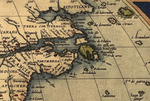
The Country of Mawooshen describes the area as a series of nine river drainages extending from Mount Desert Island on the east to the Saco River on the west. Along each river are outlined the major villages, the number of men in each, and the most critical sagamores. Overall, Purchas lists 21 villages and 23 sagamores. He suggests there were a total of 1,238 homes and 3,000 warriors, yielding an estimated total population of about 10,000 (Snow, 1976).
As described by Purchas:
“In Mawooshen it seemeth there are nine Rivers, whereof the first to the East is called Quibiquesson [Frenchman Bay/Blue Hill Bay-Union River]; on which there is one Towne, wherein dwell two Sagamos or Lords, the one called Asticou,the other Abermot. In this Towne are fiftie houses, and 150 men. The name of which Towne is Precante [Ellsworth/Sorrento?]; this River runneth farre up into the Mayne, at the head thereof there is a Lake of great length and breadth; it is at the fall into the Sea tenne fathoms deepe, and halfe a mile over. The next is Pemaquid [lower Penobscot], a goodly River and very commodious all things considered; it is ten fathoms water at the entrance, and fortie miles up there are two fathoms and a halfe [15 feet] at low water; it is halfe a mile broad, and runneth into the Land North many daies journey: where is a great Lake of 18 leagues [54 miles] long and foure [12 miles] broad. In this Lake are seven great Ilands: toward the farthest end there falleth in a River, which they call Acaconstomed, where they passe with their Boates thirtie daies journey up, and from thence they goe over Land twentie daies journey more, and then come to another River [St. Lawrence], where they have a trade with Anadabis or Anadabion [Anadabijou, the Montagnais grandchief] with whom the Frenchmen have had commerce for a long time [at Tadoussac]1603]. Neere to the North of this River of Pemaquid [Penobscot] are three Townes: the first is Upsegon [Bangor], where Bashabes their chiefe Lord doth dwell. And in this Towne are sixtie houses, and 250 men, it is three daies journey within the Land. The second is Caiocame; the third Shasheekeing. These two last Townes are opposite one to the other, the River dividing them both, and they are two daies journey from the Towne of Bashabes. In Caiocame dwelleth Maiesquis, and in Shasheokeing Bowant, two Sagamos, subjects to Bashabes. Upon both sides of this River up to the very Lake, for a good distance the ground is plaine, without Trees or Bushes, but full of long Grasse, like unto a pleasant meadow, which the Inhabitants doe burne once a yeere to have fresh feed for their Deere.Beyond this Meadow are great Woods, whereof more shall be spoken hereafter. The River of Pemaquid is foure dayes journey from the mouth of Quibiquesson [Mount Desert Islandwaters]. . . . The River Shawakatoc [Saco] . . . is the Westermost River of the Dominions of Basshabez, and Quibiquisson the [Eastern] most.“ (Prins and McBride, 2007, pp. 56-57)
Most of the locations outlined in Purchas were confirmed in a trip of Captain John Smith to the region in 1614, guided by none other than Tahánedo. As described by Baker (2004, p. 80): “Captain John Smith, a visitor to the coast of New England in 1614, clearly laid out the bounds of Bashaba’s lands and powers. He described the region from the Penobscot to the Sagadahoc as the land of Bashaba. He then added that ‘‘To these are allied in confederacy, the Countries of Aucocisco [Casco Bay], Accomynticus [Agamenticus], Passataquack [Piscataqua], Aggawom [Ipswich] and Naemkeck [Salem].’’ Here Smith essentially describes the territory of the Almouchiquois and indicates they were allies of Bashaba and the western Etchemin”.
The center of Mawooshan was at the grandchief’s great tribal rendezvous site at Pentagoet (Castine), at the mouth of the Bagaduce in eastern Penobscot Bay. In 1615, this spot became the location of a major fur trade post and stronghold that would be fought over by the French, and English, desiring the furs, moose hides, sealskins, and other goods that Wabanakis had to offer (Prins and McBride, 2007, p. ii).
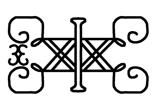
Illustration: Symbol of the Wabanaki Union of Tribes, still in use. It was originally embroidered onto the ceremonial clothing of sakoms. Frank Speck (1927) Symbols In Penobscot art. https://en.wikipedia.org/wiki/Wabanaki_Confederacy#/media/File:Wabanaki_Union_Symbol.png
Bibliography
Baker, E. W. (2004). Finding the Almouchiquois: Native American Families, Territories, and Land Sales in Southern Maine. Ethnohistory, 51(1), 73-100.
Purchas, S. (Ed.) (1907) The Description of the Country of Mawooshan Discovered by the English in the Yeere 1602. In: Hakluytus, Posthumus, or Purchase his Pilgrims (Glasgow: J. MacLehose 8c Sons), vol. 19, pp. 400-05
Prins, H. E. L., & McBride, B. (2007). Asticou’s Island Domain: Wabanaki Peoples at Mount Desert Island 1500-2000. Acadia National Park. Ethnography Program. National Park Service.
